Does Curitiba Live up to the Expectation of Being an Environmentally Sustainable City?
Info: 10823 words (43 pages) Dissertation
Published: 10th Dec 2019
Tagged: Sustainability
CURITIBA
Growth & Development Chronicles and Assessment
Planning Theory Assignment
Abstract
The global ‘Sustainable city’: Curitiba has shown tremendous spatial growth in the past six decades. The accelerated growth has been the result of aggressive economic and technocratic political regime which was continuously supported by a coalition of ideas of the political sculptors of the city. But this process of development has occurred at the social cost, and now in the 20th century, it has started cracking the ‘Model city’ image of Curitiba. It has posed a question as to whether in reality is the planning agenda of Curitiba panned out as its leaders had envisaged?
Introduction
Curitiba is the capital and one of the largest growing city in the state of Parana, located in the southern region of Brazil. Established in 1698, the city within two centuries gained international fame as “a model for urban ecology planning” and “a model of efficient, sustainable city” of the 20th century[i]. Curitiba grew at an average rate during 1850-1940s, a growth associated with manufacturing and exporting locally produced agricultural goods. But it experienced a significant growth after and rapidly became the global industrial hub with highest growth rate in the country, an average of five percent a year[ii] [iii]. Alongside Curitiba, many Brazilian cities grew at an unprecedented growth rate, which caused numerous urban problems and ultimately urban crisis. The unplanned urban development in Brazilian cities in the mid-20th century called for the imminent need to control.
With the same agenda, Plano Director-a master plan received approval in 1966 for the development of Curitiba. The main aim of the master plan to integrated transportation and mixed-used development- an axial model urban expansion.
From the conception of the Plano Director and over subsequent decades, the planning regime of Curitiba has been considered as “A model of environmental planning,” a remarkable example of how the implementation of radical ideas spur successful environmental planning processii iii [iv]. Curitiba has been singled out amongst the third world cities for the way- innovative, functional, efficient and replicable; it has addressed the issues of urban transit, development, and sustainabilityii [v]. The purpose of this paper is:
First, to document the effective and continuous urban planning process of Curitiba, which has led to efficient socio-economic development encompassing urban transit, preservation, and revitalization of humane values that have improved the city’s quality of life and built environment.
Second, to critically assess the results of politics in the urban planning processes on the social and physical fabric of the city. To reveal current governance issues that have stemmed from the failure of the municipal and state authorities to actively participate citizens into urban planning and implementation process.
Storylines of Curitiba as “model city” depicting sparkling trajectory of the sustainable growth are just a few handpicked parts of the complete story. Many scholars have pointed that the hegemonic planning process since 1960 has been controversial and in conjunction with mainly three elementsii:
• The accommodation of diverse interest around a single political agenda and project
• The massive media dissemination of “Environmental” image
• The permeation of some material gains to lower income class
The paper thus aims to answer the question “Does Curitiba lives up to the expectation of being an environmentally sustainable city?v” and looks at these factors to obtain factors that are causing cracks in the current -technocratic regime model- that might in future undermine the accomplished successes of the city.
The evidence of the first factor is the socioeconomic polarization of the center and the periphery that has led to social inequalities. Another is the absence of coordination amongst different implementing agencies. And, the last one challenging the government is the need for citizen participation in the planning process. Thus, this paper presents a synthesis of the planning process accomplishments of Curitiba, the primary factors that have made the success possible and most relevant criticism that challenges the future of the city.
Making of Curitiba
Curitiba’s development and planning history
Curitiba became the regional center of Parana in the 1850s and its peripheral location played a more significant role in its development as the transitional town between two major cities in the 19th century. It is due to this reason that the region gained the benefit of the economic market and the passage of Law of Lands led to the flourishing of agri-production in the city. This development was further supported by several waves of the European immigrants and, the town established itself as the center of trade and industry, the growth also spurred by the construction of the rail between Curitiba and Port Paranagua. Curitiba had absorbed several waves of immigration by the end of 19th century, the population grew from 12,600 residents in 1872 to 49,700 in 1900; and another wave of 27,000 immigrants from 1907 to 1914. But, Curitiba has mostly been developed in post-world war II, and holds the six-decade history of formal urban planning[vi].
The population of the city, at an annual growth rate of 7%[vii] vi, increase by three folds in the first half of the 20th century-180,600ii people. This sparse development and constant wave of immigrants called in for early planning implementation. And it all started with the Agache plan in 1943, designed by a French urbanist Alfred Agachevi. This plan established the early roots of concentric growth of the city through the restructuring of the street network and guidelines on land use development as show in Figure 2. The plan also provided guidelines on the sanitary measures, distribution of the open recreational spaces and allocation of lands for the urban expansion. The plan was prepared for a population of 120,000 but unprecedented urban growth failed the implementation of the plan.
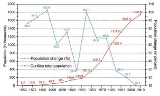
Figure 1 Population Growth in the period 1853-2010
By 1960 the population of the city had almost doubled to 361,309, and called for the management. The growth of Curitiba was due to migration[viii] and rural exodus from the hinterland-the displaced farmer-a resultant of the agricultural mechanization. The economy of Curitiba post-1940’s shifted from agriculture-followed by black frost that destroyed the coffee bean plantation- to manufacturing and export center for produced goods. Due to Curitiba’s competitive advantage over other metropolitan regions of Brazil- in terms of quality of lifestyle, climate, and economic opportunities- it presented an opportunity to the rural unemployed population to move to the city in search of jobs. To accommodate the incoming rural immigrants and to adhere to the rising need of employment, the then mayor Braga opened a competition to re-envision the city plan. Jorge Wilheim was appointed to prepare Plano Director. The two major thrust forces driving the master plan development were: first to strengthen Parana’s limited economic infrastructure and other to foster more industrial activity[ix].
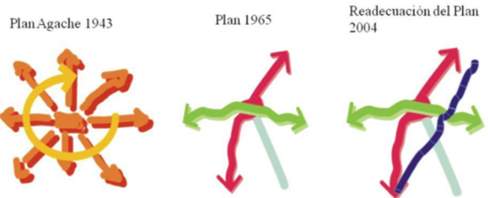
Figure 2 Agenda of Master Planning from 1940-2004
Unlike the Agache plan, Plano Director was based on the radial linear expansion of the city’s growth as shown in Figure 2, while integrating the land use and transportation. Moreover, it guides growth management, promotes industrial development and improvement of the environmental quality. The new plan instituted creative approaches for shaping the urban fabric, channeling growth and defining specific development zones-CBD, structural sectors and residential. During the population boom in the period of 1940-1970, the new residents settled around the center city and along south-southeast region of the city along the major axes. This is the reflection of the Plano Director which shifted the focus from ring-concentric style development to radial-axial development by introducing northeast and southwest axes iiivi.
But it did not stop here, the need for economic support was growing with the need for new infrastructure. This demand led to the creation of Curitiba’s Industrial district which was the new ‘Creative Economy’ of the city[x]. The municipality triumphed with more immigrants-unskilled and poor- and the population of the city reached 609,000 in 1970. What was interesting about this time was that growth rate of the surrounding municipalities was 14%; however, these municipalities were not part of the master plan and were left unregulated to be developed organically. This ignorance of the municipal body gave birth to favelas and informal housing markets around the city in the periphery. The new creative center demanded housing solutions to accommodate the poor immigrants. The city initiated slum relocation schemes to help the needy families living in the outskirts of the urban region. Discarding the popular notion of building high-density public housing, the public housing company COHAB-CT aimed at creating diversity through different types of housing options. The favelas often were located in the outskirts of the city, but these programs proved to be insufficient in responding to the growing demand for housing. And while waiting for subsidized housing and in absentia of the affordable housing market, the poor immigrants were forced to reside in the informal housingvi.
The large disparity in the rate of population growth between the city and the state had continued until 1980’s, when the rate decreased to 2.29%. The reduced rate was accompanied by unemployment, which had reached 10-12% by 1990 (Hugh 2004). The metropolitan region which was still growing at the rate of 4% experienced a 15% unemployment rate. This situation presented the city with a new challenge of adhering to the employment issues. In 1990, city created Municipal Housing Fund (FMH) with the purpose of providing financial support to housing programs for lower income groups. The funding came from the transfer of the government owned real estate, generated income from development incentives such as transfer of development rights and budget appropriationii. The focus shifted from physical planning to human development. The city introduced programs for-education and skill building; jobs and housing programs etc-aimed at structuring the creation of jobs and generating income for the fifteen peripheral barrios. To expand the access to knowledge 40 lighthouses-neighborhood libraries were built. Also the city initiated innovative ideas for managing the solid waste-‘Garbage that is not Garbage’ and ‘Garbage Exchange’, which was aligned both at benefitting the poor and environmentally sustainable practice. The city’s population boom and rapid urbanization has been an expensive processvii.
In 2000s the population growth continued at reduced rate of 0.99%. The spatial growth extended beyond the municipal service region-an outgrowth of 25% between 1990-2000 and there was significant sprawl and exurban growth[xi]ii. With an area of 434.67 sq km in 1940 and density of 324 residents the city grew to 4030 residents per sq km in 2010. The next decade the policies and planning significant importance was given to urban design projects. One such project was Our Village which aimed at upgrading urban life through land tenure mechanism of the existing informal settlements and to prevent invasion of new lands, economic upgradation of the favelas. Live together promoted expanding of social infrastructure; Learn aimed at creating virtual learning spaces across the city to foster knowledge building opportunities; 2000 plan aimed at community partnerships to give impetus to sector urban design developments; Technological Curitiba emphasized on innovation of urban and ecological technologies. Citizens in Movement aimed at educating population masses about the transportation systems through capacity building tactics.
Today Curitiba has grown to being home for 1.8 million people, with metropolitan region booming at 3.1 million. It has become the 7the largest city of brazil and resides 29.8% of the Brazilian population. The city has done much in the past 60 years to improve the quality of life through addressing and managing urban contemporary issues of transportation, land use and sustainability in most radical, efficient and cost-effective manner. And is no wonder that it has achieved global recognition and is held as a model city for next generation urban planning and management. Although, Curitiba had been successful in becoming a global entry port for many industries and institutions due to is geopolitical and infrastructural, the declining population and high inequality in the city presents with contemporary issues. Which if not dealt with immediately might hamper the growth and development of the city.
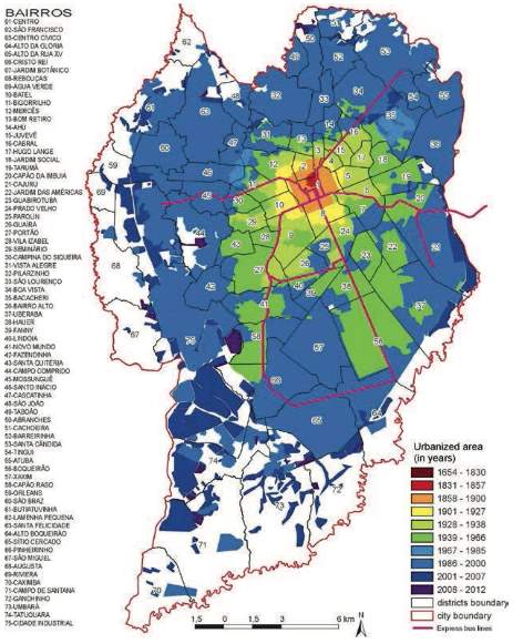
Figure 3 Spatial Growth of the city since 1654-2012
Economic development and Human development
The population growth and urban development of the city has been accompanied by economic growth and development. The coalition of urban authorities and the business elites took the opportunity, during 1960s, to use the laid infrastructure as a tool in dictating economic growth and in the process also dictating the spatial fabric of the city. Curitiba, after implementation of Plano Director which aimed at pro-active economic development, aimed at completion to become regional center of Parana through promotion of ‘better quality life for the citizen’. This competition led to the decline in the economic attractiveness of Sao Paulo, one reason was exhaustion of infrastructure, and industries choose Curitiba over it. In 1970s the industrialization in the state of Parana gained momentum with establishment of global automobile companies Renault (with investments of US$1.12 billion), Volkswagen/Audi (US$750 million), and Chrysler (US$315 million[xii]. The city’s industrial base expanded in southwest, benefiting and attracting growth of elites. The industrial district agglomerated both complementary and competitive industries. During 1970-1980, Curitiba experienced an economic growth rate of 11.8%, higher than the national average of 8.6%. Curitiba’s establishment as regional and global industrial center brought foreign investments to the city, improving the quality of life as municipality increased the public investiture in improving the infrastructural services. Although in 1980-90s when the country experienced a dip in the economy, during economic recession, Curitiba’s economy grew at the rater of ~4%. The dip experienced in the economic growth, can mainly be explained by the dominance of Fordist economy-dependence on single type of industry. By late 1900s till 2000 Curitiba’s economy was growing at a constant rate of 3.6%xiii and the GDP was US $ 12.1xiii billion. The per-capita gross domestic product has increased from the national average-US $ 4000; city shows higher expenditure power for basic commodities such as food, housing and clothing. The unemployment rate of the city during 2000-2010 was 4%,xiii which although has been rising since 1970s, was comparatively lesser than the national average.
Under the pragmatic leadership of Jamie Lerner, the region not only experienced economic development but rather fostered human development. Economic development along with complementary efforts of the pragmatic leaders also fostered human development. Curitiba has a Human Development Index-a measure of health, education, life expectancy and quality of life- of 0.82[xiii]. These were results of constant advocacy of improving the quality of life through master planning mechanism. The economic led transformation during the period 1960-70 and urban development were largely driven by the idea of improving the quality of lifestyle through physical planning and design. Until 2000, the master plans, projects and the power leaders were ignorant to the rising social need of the population, and this ignorance gave rise to grave social inequality which the city experienced during 2000 till dateii xiii.
Although, programs such as Lighthouse of knowledge were implemented in 1995, the efforts for improving social quality of life of poor were disregarded for long.
In the past two decades, the focus of the development has shifted from aggressive economic-authoritative development to more citizen participatory-socio-Economic equality driven. To mitigate the income inequality that persisted during 1990-2010, social development reforms were initiated such as Our village-inclusionary program from favelas which focused on housing and job opportunities, Live together-upgradation and provisioning of social infrastructure to the communities; Learn, Plan and Technological Curitiba-focused on skills and capacity building in industry, city and globe respectively.
Drivers of growth
The development of Curitiba post 1960s has been economically driven with primary focus on improving the quality of lifestyle during the process of it. Apart from the growth driver such as rural exodus, international migration, agglomeration of the economies which we discussed in the above sections, this section of the paper we talk about three primary drivers of the urban growth and development which shaped the city since 1960sii ix. These were namely –
- Unanimous of Interest the city sculptors over a project;
- Creation and promulgation of hegemonic Image of the city
- Marketing material gains to lower income groups.
Geopolitical coincidence of Interests and Ideasii
The principal factor that contributed to the transformation of Curitiba was the coherence of various political sculptors around a single political project since the 1960s and until present. The Political succession and Business class Elites, since the inception of Plano Director, have strategically supported the planning processes in Curitiba. The case for administrative continuation in Curitiba’s government is unique in Brazil and rare in Latin American history, which has successfully supported and carried out the master plan until now. The planning regime continued due to three factors:
• Institutional mechanisms that retained political will
• Leader of the government unanimously supported and adhered to the plan
• The role of elites in implementation and success of the plan
The creation of unique institutional structure, different from other Brazilian cities which stalled the process due to political complications, became the critical element in fulfilling the implementation process of the master plan. In 1964 when the preliminary Plano Director was proposed it was in conjunction with the municipality and the CODEPAR (Curitiba and the department of economic development and led to the development of IPPUC, this institution surpassed the bureaucracy to led a technocratic urban planning regime. Because there was a military dictatorship, the innovative plans implemented by the Lerner group leveraged the continuation of it.
Secondly, with aggression of the project and the success of the first projects led the successive mayors to strive for more. Although there were few, who opposed the implementation but could only follow the plan since much had been already changed in the city.
Lastly, the innovative implementation of the projects was at all times compatible with the ideas and development of the businesses; chiefly in the sectors of industries, real estate, construction and public transit. These elites directly or indirectly influenced the decision-making process and structured the growth of the city. Formally through the business/industrial sector and political representation; and informally through personal relationship and lobbying. The inclusion of business elites in the decision-making process can be well understood since plano director was borne out of the need for economic development that led to the creation of the industrial district favoring the businesses.
Thus, Curitiba showed a continuation of hegemonic domination from before 1960’s and technocratic planning that became the definers of planning. Over and above that, the elites and their constant supported funneled the governance and implementation of the plan, making it a robust global cooperative model.
Advertising the Image
When in the global arena of competition, cities more than often use self-created images to market themselves; which are partial truth and presents distorted reality to the citizens. With the increasing use of multimedia, it can be used to influence the image of the place beyond what they are in entirety. Curitiba is one such example, it has exploited the multifaceted media and the planning discourses to project a particular image[xiv]. The way the process of urban development has occurred and continues to evolve are over advertised marketed exploitation to create a hegemonic urban imagery.
Notwithstanding the real enhancement of urban quality achieved in the city, as well as the improvements in other sectors of planning, the effect of image building has been much powerful than the reality. And hence every step to improving a sector has been overly exploded and exploitedii. What the image presents is that the citizen has to do nothing to achieve high quality life, everything is already in place, but is that the case? Curitiba’s quality of life index in comparison to other Brazilian cities have been deteriorating. And as Teresa Urban comments about the initiative undertaken in Curitiba, ‘are concerned with the appearance than with efficiency. They appear more as a solution than they are a solution’ii. At the same times the needs of the citizens have been highly bolognaised in the media as ‘city is for all’ when it indeed it favors the lifestyle and preferences of the middle and upper income classes[xv].
Material gains to citizens (Irazabal 2005)
The last factor that mainly propelled the growth post-1970s was the idea of ‘providing some material gain to the lower income.’ Successful implementation of the hegemonic projects was not possible without the redistribution of the material gains. Curitiba has promoted the prevalence of inhabitant positive assessment and has distributed ample amount of benefits to the citizens through programs implementation such as RIT (integrated transport network) and ‘garbage exchange.’ RIT has indeed had primarily benefited the lower income group in substantively relieving the travel budget and has also claimed for improving the quality of life. The RIT not only assisted the poor by increasing the access to transit disadvantaged population, but the integrated land use benefited the elites and the middle-income group. Over the course of time, critics have criticized the ever-increasing importance given to the ecological sustainability of the transit system. Firstly, that the medium and higher income classes have not sufficiently developed the appreciation for the use of public transit, and with automobile industries in the city itself, the ownership has been ever increasing. Paradoxically, since the lower income classes have been forced and pushed to relocate farther and farther outside-since they cannot afford the housing in the center and near transit axes- the people living near the transit are have the lowest ridership indexes. This weakly regulated market forces and subservient policies have increasingly led to transit unserved regions.
Another program that projected the image of participatory and wellbeing planning was ‘garbage is not garbage.’ By which the households undertake segregation practice, the add-on to this program is exchanging the collected waste to travel voucher. What this program promotes is temporary employment opportunities for the urban poor, social weaker sections such as drug addicts and capacity building training.
Conclusion
Cities enable collaboration of knowledge, as it enables free flow of the ideas from person to person, and people are willing to pay higher urban prices to collocate themselves where they are surrounded by talented peopleii. Curitiba is one such example of the different collaboration of radical ideas that enabled the city to live up-to its global benchmarks. Curitiba’s urban growth cannot be subjected to one type of theory, rather it is confluence of many theories together. Curitiba’s advantage of newly improved urban lifestyle-where Sao Paolo was suffering from traffic congestion and urban poverty- was an entry port to intellectuals in it 1950s-1970, where it pulled global masses and accommodated various waves of immigrants. The city with its ideology of ‘Sustainable Tomorrow’ triumphed both economic and urban growth. But with that came both the richest and the poorestii population, making Curitiba a great place of consistent inequalities. One might think that cities are full of poor people, it is not that city produces them, rather they attract the poor with the prospectus of better lifeii[xvi]. Curitiba slums are densely packed because the life in a favela, beats stultifying rural poverty experienced by the farmers. The rural exodus in the periphery of the Curitiba mobilized the movement of urban poor in the city. The new jobs, the enable market due to densification etc. More than often poverty is determinant of decline in the quality of life offered by the city, but they show how economically well the city is functioningii v [xvii].
In 1980-2000 Curitiba earned a global status leading in urban innovation. It became the creative and knowledge hub of many international economies. Cities like Curitiba become nodes of increasingly creative and knowledgeable globalized world. The city grew vertically, for centuries taller buildings have crammed more densities without them confined into coffinsii. The verticalizationxix gave momentous to agglomeration of the both local and urban economies, fostering the economic needs of both core and the periphery. Curitiba became place of brilliant ideas of urban entrepreneurs. Indeed, this aggressive innovation led development leave places behind like slums, housing demands and need for cleaner economies
It is necessary to understand the critical standpoint view of the planning practicesii undertaken in Curitiba, but it would be entirely unfair to judge it just by that. These urban issues are generally experienced by all the growing municipalities across the world. It would be ideal for the city to promotes programs like ‘garbage exchange’ that has benefits to the most deprived section of the city, but with an enough clear understanding on that these just palliate the complex issues of socio-economic inequality, and is not an ultimate solution.
Spatial Growth
Between 1990-2000, Curitiba urbanized from 89.66 sq km to 109.63. Due aggressive urban growth in Curitiba during 1990-2000, substantive land development occurred and the city converted 19.97 sq km area. In terms of the land coverage, Curitiba is 52.7% urbanized in comparison with the country. In this section of the paper we discuss the spatial growth of the city and the forces that led to the expansion of the city. And what were the spatial implications of the implemented policies post 1960s?
Spatial Growth of the city
The metropolitan region of Curitiba can be divided into three concentric rings namely-
- The first ring or metro urban agglomerationxii
- The second ring
- The third ring
Furthermore, the spatial pattern of urban agglomeration can be explained in five rings on the bases of how development occurred over the course of 1650s-2010. From 1650s-1910’s Curitiba experienced spare organic development, until 1943 when the Apache plan was conceptualized, it aimed at concentric ring development with core and automobile oriented mobility as its guiding principles. With unprecedented growth and a need for more urban development plan to decrease the pressure on center, 1960s called for preliminary master plan -Plano Director. It called for linear axial growth served by rapid transit system. The guidelines called for
- Linear growth from downtown tangential rapid transit routes that would facilitate continuous development progression
- A hierarchy of routes
- Preferential development along the northeast-southwest axes
- Multiple commercial centers
- Increased urban concentration
- Extension and improvement of green spaces
- Establishment of predominantly pedestrian areas in the core city
- Creation of unique landscape.
The master plan unlike Apache plan which was developed to curb the unplanned growth, aimed at accelerated growth and development. The spatial structure of the city envisaged was primarily based on –road system and mass transit, economic Land uses and residential densities. The plan guided the development of trinary road system-higher density mixed used development along the dedicated BRT lanes, and as one moves away from the center the density tappers town. The municipality’s emphasis on northeast-southwest corridors was to oriented high density municipal growth especially housing along the arteries. The idea was that the increased population density was facilitate economies of scale in housing and bring down the real-estate market, provide for more efficient transit ridership making the modern investment in transportation more feasible. The plan provided zoning guidelines for the permissible development as an effort to established order. As a result of this policy implication, high-rise apartments sprung along the corridors, but unlike envisioned by the master plan, they failed to meet the demands of the growing population.
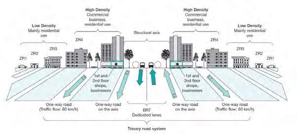
Figure 4 Trinary Road System explaining the density
So, although the state, in theory, leveraged the local real-estate market, the guidelines left much to the discretion of the municipal authorities and had a no-built mechanism for coordination between the local master plan and the municipalities. These lose developmental policies, and elite politics led to the construction of more high, condominium styled development along the axes. By 1970’s upper-class dwelling occupied the corexiii. By 1990 Curitiba had 100% urbanized as shown in Figure 1. But unlike other Brazilian cities, 70% of Curitiba’s population was resided within 10 km distance to the center, with per capital travel distance of 9.5. The same media campaign that attracted masses based on the quality of life also lured the rural poor to the metropole. Since the 1970s they have been populating the periphery at a rapid pace. Post-1990, half of the city growth that Curitiba experienced, happened beyond 10 km. As shown in Figure 6, the most land conversation occurred beyond the urban boundaries. By 2000, 41.4% of the city’s population displaced themselves in decentralized suburbs and exurbs, which were beyond 25km radius from the centervii. This leapfrogged development[xviii]– premature development of the periphery-was the result of the planning restriction and government ownership of the land that distorted the urban land market; forcing the periphery to develop prematurely. “Peripheralization can be understood as a projection to the space level of the capital accumulation process and its consequences to working class’s habitat, which determines its spatial segregation to increasingly remote areas away from the heart of the main urban- industrial centers of the country”[xix] [xx].
With lack of regulations and urban monitoring the periphery had little choice, but to adhere to kaleidoscopic disconnected development. This lack of control over the real-estate market triggered sprawl excluding the most deprived section of the cityii. The disenfranchised were left susceptible to environmental risk in the periphery. By 2000, 9% of the population resided beyond 25km radius from the core, in the edge.
Another way to look at the spatial pattern is the density gradient of the city. As cities expand the population, density gradient flattens out. The population density gradient of the Curitiba is shown in the Figure 5. Curitiba has a steep negative gradient of 16.6%. This shows that how masterplan guidelines impacted the placement of the densities in the 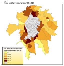 city.
city.
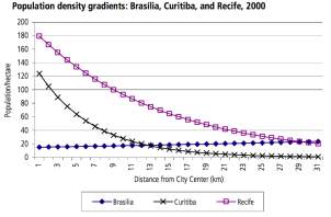
Figure 5 population gradient of Curitiba Figure 6 Urban land conversions 1991-2000
Curitiba experience significant amount of very low density suburban development in areas beyond the radius of 10km –despite the implementation of the density oriented planning. The trend of metropolitan region growing more than the center lead to emergence of ‘dormitory-cities’xix. Thus, the direction in which the urban planning was implemented in Curitiba triggered social disparity, strengthened the polarizing effect of the core and the periphery, disregarding the metropolitan scale.
Such exclusionary economy and inequality impacted the spatial fabric of the city, marked by spatial segregation[xxi]. The effluent lived in the center, where more public investment in infrastructure was agglomerated along with stricter enforcement of urban regulations that limited its access to poor. The poor, as discussed in earlier sections, lived in the peripheries in squatter settlements with no or limited access to infrastructure services – more than often in dilapidated, poor housing structures; and with insecure property tenure.
These exclusionary practices were indeed product ofxx
- Low wages
- Concentration of land rent by private properties
- The cost of urban regulatory regime
- Use of public investment favoring accumulation of industries and infrastructure
Curitiba experienced two types of segregation as a result of the implementation of the infrastructure led technocratic plan:
- Economic Segregation
- Racial Segregation
Both the segregations were more or less result of the other one, but Curitiba has experienced more economic segregation rather than racial.
Spatial Segregation
One might argue that cities often have home the poorest, but it is not that the cities produce them they are rather the product of the planning process that the city implementsviii. Inequality in income distribution was an important characteristic of intensive economic development undertaken by Curitiba in 1960-1980. The Gini coefficient-a measure of income inequality measured by UN-rose from 0.5 in the 1960s to 0.6 by 1990[xxii]. Another measure of economic inequality was, 30% of the total households were earning wages below the national thresholdvii. Brazilian cities were amongst the most unequal in income distribution across the world. Another measure of income inequality was This income inequality, not so surprisingly, spurred spatial economic segregation; with rich occupying the center and the poor in the peripheryvii vi [xxiii]. There can be two reasons for explaining the poverty – first, the accepted low wages due to lack of economic opportunities and skills citizens accepted low wage rate; second, the industrial development could not absorb the immigrating influx completely resulting in increased unemployment and poverty over the course.
Another factor leading to segregation was the racial component of the demography. During 1872 it was noted that more than 35% of the total population was composed of the African Americans, with rapid economization the first two waves brought the whites skewing the racial balance of Curitiba. The ‘Whitening’ of the city made Blacks the minority and susceptible social exclusion from the planning process. Both these processes impacted the spatial structure of the city. The incoming Asian and Black population were comparatively economically weaker as compared to incoming white population, and the exclusionary Fordist planning regime denied them access to the center.
The city experienced two types of spatial segregation:
- Segregation in the center
- Segregation by polarization at the periphery
Segregation in the center
As earlier discussed in this section, the Plano Director aimed at high-density development this high-density development was accompanied by the dynamism of the real-estate market. The core of the city became affordable to the wealthy classes of the city. The verticalization process and its business spillovers indicated the high level of real estate around the center, soon became the way of living as perceived by the HIG. The city grew, as directed by the master plan guidelines, towards the west. As many theorists have demonstrated thatx [xxiv]. The wealthy tend to agglomerate with the likewise community. Which doesn’t mean there is non-outside, but the concept of homogeneity exists in them. This theory could also be observed in Curitiba as a new center emerged in the west of the city. This new center proliferated in the west and south-west regions, completely ignoring the northern settlements. Lack of government regulated the market and soaring rental market the poor were disabled to access the central housing market. Also, the NIBYism of the elites played a more significant role in this process. Strict land use regulations and policies left so much of the space for the real estate developer to earn the maximum profit of what was available. Studies have found that almost 20% of the housing is located outside the 10km radius of the city. The Figure 7 shows the comparison of the formal and the informal housing located in the city.
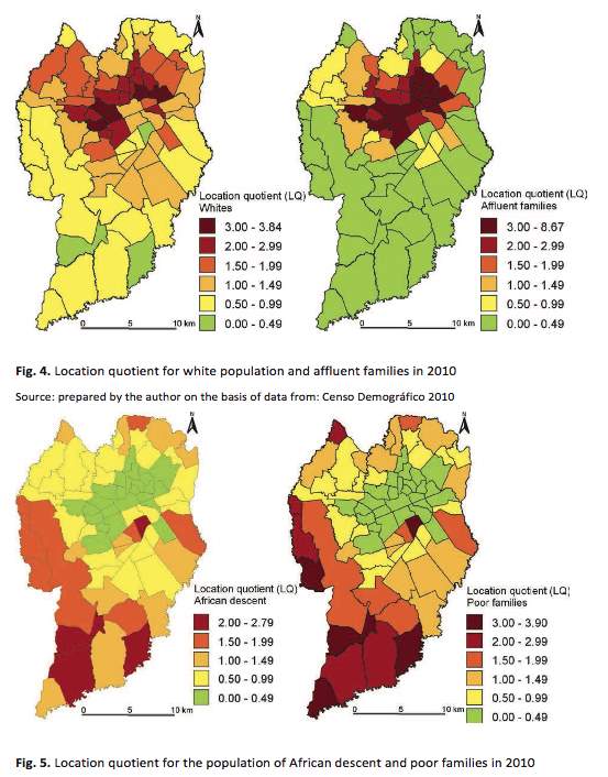
Figure 7 Spatial mapping of Race and Income
As it can be seen that there is a correlation between wealth and race in how they spatially sort themselves. Both the wealthier and ‘Whites’ were concentrated in the center of the city pushing the minorities and disenfranchised towards the outskirts.
. Segregation by Polarization at periphery
With changing demands, the city experiences the outward movement of the wealthier class. This action did not lead to the reduction in the earlier suffered segregation instead it accentuated the situation. Segregated vertical gated communities rose alongside the informal housing, and the city was now experiencing dichotomist alienation and community exclusion with the proliferation of the edge citiesxix.
The mistrust between the rich and the poor; white and black have been since inception driven the sorting processii [xxv]. Driven both by fear and the quest by other group, residents of enclaves isolate themselves from the ‘perceived’ animosity and lifestyle of the so-called ‘outsider.’ Curitiba experienced something similarii.
The city was not only polarized between the center and the periphery; but experienced the pull within the core itself. Areas with the same with the same regulation did not develop in similar patterns. The areas closest to the center and where the wealthy superimposed-had highest real-estate values- were developed as high-end skyscrapers. The elites controlled the city and stimulated the growth of ‘Spatial Segregation’ by choosing the best accessible landxix.
Spatial model of Curitiba[xxvi]
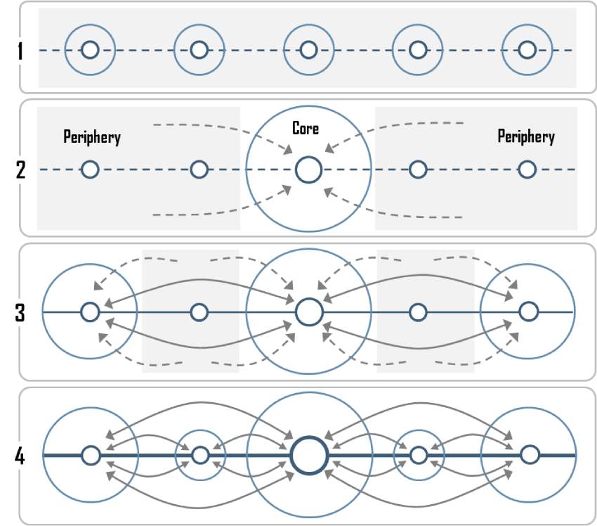
The spatial growth of Curitiba can be explained by two different theories-
- The core-periphery theory- it explains how Curitiba has grown as a metropolitan region
- The sectoral theory in conjunction with peter muller’s city model- it explains how the urban agglomeration or the city expanded in the past 6 decades.
Core-Periphery Model of the metropolitan region CMR:
The core-periphery model conventionally represents the emergence of regional center of Curitiba, primarily in four stages :
- Pre-industrial stage: when the development was sparse and Curitiba’s spatial geography acted as dormitory node to the traders between the regions.
- Transitional Stage: 1940-1960, when Curitiba emerged trading center as the agro-manufacturing and logging industries, which was accompanied by influx of peripheral population
- Industrial stage: 1960-1990, intense economic growth and polarization of the periphery
- Post Industrial stage: post 2000 stage, Integrated urban system, emergence of other regional centers and ameliorated spatial inequalities
Urban core and its spatial theory
The urban agglomeration of Curitiba is not confirmative to one spatial theory, rather a mixture of three theories in practice. A conceptualized axial development, the city’s spatial structure largely confirms to Urban growth model developed by Peter Muller. What Muller say is, that the city grows in response to the mode of transport and at all times try to minimize the travel times to less than an hour Figure 8.c. Based on the same concept, Curitiba adopted transit oriented axial development aiming at high density development concentration around the axes. Although this vision of the municipality did spatially determine the direction of the growth, but the land regulations and several waves of the immigrants decided the fabric of the city. The land regulations encouraged economies to develop around the axial corridors in form of a sector; thus being accessible to the masses through the RIT (transit network). The settlement of different industries, as discussed above, determined were the incoming immigrants settled. Both Figure 1 and Figure 7 show that the first wave of immigrant- the Europeans and the wealthy settled in the center, next wave Asians and less wealthy settled around the near access to the business and the last ring was formed by the poorest section.
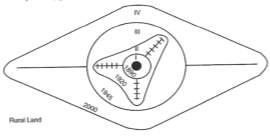
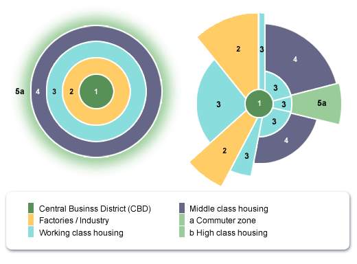
Figure 8 Concentric Ring theory, Sectoral Theory & Urban Growth theory
Urban governance
This section of the paper focuses on the analysis of the governance structure of Curitiba as an evidence of the relationship between urban social, cultural, economic and political environment. There are as DiGaitanoii says three components of the urban governance
• Urban political economy
• Urban governance agendas
• And Ailments
Urban Political Economy
Urban political economy component of the governance embodies economic, social and intragovernmental relationship and functioning. Major urban social restructuring and structuring happened in Curitiba in the 1960s. The interplay of national, regional and local forces determined the socioeconomic and spatial arrangements of the cites. Curitiba has served as a node for industrial development and has experienced a tremendous increase in the population since the 1960s. The incoming new population were poorly educated and demanded social infrastructure. Curitiba uniquely restructured itself directive mode, where the nation or state directs and monitors local policies and programs to permissive mode during 1960-1970. The permissive mode allows more involvement of the local government in administration and allocation of the financial support. Under the directive mode of intervention, many agencies such as CODEPAR financed the urban government projects, until the establishment of IPPUC under military rule. Although established during directive rule, under the leadership of Jamie Lerner, facilitated the transformation of the local planning institution- fostering independent design and implementation of the local urban plans. This new earned independence in decision making led to the establishment of many agencies such as CIC, COHAB-CT, UBRS, MHF/FMH, COMEC, and FAS that intervened and influenced the growth and development of the city.
Urban governance agendas
As discussed in both section 1 and 2, local political, business and planning elites shaped the pro-growth, corporatist government regime to carry out the technocratic development of the city which led to spatial transformation. From 1960-1980s the primary agenda of the government was encouraging business and industrial development; and post WWII promote economic development that led to well being. And as discussed earlier, these forces aimed at improving the city’s position as a regional center. This again was mentored and formed around the strong and pragmatic leadership of Jamie Lener. He aligned the business interests around single political agenda that linked the business elites and economic developers. During this period IPPUC and CIC played a critical role in assimilating and creating an industrial base for the city. Since they aimed largely at economic development, the consequences of the neglect to other sectors called for a more radical approach to manage the externalities borne out of the single-minded development. Post-1980s when the city started facing urban managerial issues, it slowly shifted the focus from pro-active growth driven agenda to more growth management and equality considerations. Focused on applying defensive strategies; aiming at limiting the spread of social inequality through land use planning and regulation; capital improvements. Alongside the political agenda also entailed the management and development of the environment and protected it. It was during this shift that the planning regime felt the need to adhere to the growing demand of the urban poor and in response established institutions such as COHAB-CT. The agency was involved in curtailing the widening urban inequality through housing mechanism- one through provisioning of subsidized affordable housing within the city limits and other by providing housing finance options to self-improve the living standards. Also in 1988, although it was a result of the mis-management and ignorance for long, the constitution understood the rights of people living in the informal settlements and granted more power to the decentralized bodies to intervene. Which led to the formation of FMH to monitor and regulate, provide financial assistance to the poor to improve the housing conditions. Also, in 1990, the authorities such as IPPUC shifted the policy focus to preservation and development of urban environment-approving the improvement of watershed management. But as discussed earlier, the municipality and other bodies were unsuccessful in curtailing the unorganized peripheral growth, until the situation deteriorated so much that the government could no longer ignore. In 2004, the new government under the progressive and advocative leadership of Cassio Taniguchi undertook a social reform agenda, laying more importance to community development rather than entirely focusing on economic development. The project and programs conceptualized during 2004-2006 focused on empowering the disenfranchised population and aimed at social, economic and environmental justice; despite of these spatial justice was still missing. Institution such as COMEC and FAS were institutionalized during this period to undertake social reformative projects such as Our Village, Lighthouse etc. Although, the criticism of Our Village states that agenda of the program was rather to prevent the spread of social ills ‘Favelas’, and this duality of the program accentuated the problem of segregation in the periphery.
Governing Ailments
The planning governance ailments arise of these participatory issues, these governance ailments can be resultant of two components governing alliances and power structures. Both these are important in promoting civic participation. Governing coalitions unite the power structures and the civic masses with different interest around a common policy agenda for the collective formulation of possible solution. On the other hand, power structures play an important role in allocation of the political resources amongst the political leaders. Curitiba exercised systematic power to influence urban planning and enabled business interests. The alliance of business elites around the business interest has been detrimental factor in the growth of the metropolitan. Since 1990s the government has understood the importance of citizen participation to maintain the cohesiveness of the development. Curitiba since the beginning practiced power structures through creation of government and planning agencies- an institutional led governance. 2000-2010 dawned for the new understanding of the citizen participation for the fruition of the urban projects, which led few agencies like COMEC to bargain the power. Many favelas under the new planning regime during 2004-2006 were given formal status and slum redevelopment programs Our village, were initiated to attain equality. In the recent year the planning discourse has shifted to practice inclusionary planning practices by citizen capacity building. Indeed, it is reflective of change in ideology, it still remains in the discourse and lacks implementation.
Although, it can be concluded that Curitiba’s governance structure has been non-decisional and power-driven structure, there has been few attempts of public participation-at least from the marketing standpoint of view. The Figure 7 shows the Arnstein’s public participation ladder superimposed with planning agenda; and at what level Curitiba was during that period of time.
| 8 Citizen Control |
SOCIAL REFORM |
|
| 7 Delegated Power | 2000+ | |
| 6 Partnership |
GROWTH MANAG. |
|
| 5 Placation | 1990-2000 | |
| 4 Consultation | 1980-90 |
PRO-GROWTH |
| 3 Information | 1970 | |
| 2 Therapy | 1960 |
CARE TAKER |
| 1 Manipulation | 1940-50 |
Figure 9 Super imposition of Arnstein’s & DiGaetano and Klemanski’s citizen participation model
The governance of Curitiba and its results has made it emerge as a growth machine over the past five decades, which has been spitting out projects by excising power. It has become a critical example of how empirical and normative ideas of the political alliance interact and transform the city.
Planning Debates
Curitiba’s narration of successful sustainable-an integration of transportation and land Use-implemented by the power-driven political elites who excised technocratic pro-growth agenda; should be looked under the light of the fragmented development of the metropolitan region. The development of Curitiba has been primarily shaped by three main agendas-coalition of interests around single political proposal, media projected sustainable image and Entrenched idea of material gains to citizenii. These single-minded approaches of the political leaders and shapers of the city have stimulated discrepancies in regional planning, which they were and are unprepared for. Several factors have started cracking the best practices of past, but there are three which might undermine the success of the city and led “a successful planning model gone bad” scenario if not dealt in near future. These include
- Increased Urban crisis
- Growing planning consciousness
Urban Crisis : Environmental harm and Inequality
The first factor undermining the future growth of the city is sharp increase in the urban problems and inequalities. Social and spatial inequalities in other top-down planned cities have been results of lack of existent planning mechanism; but what is anomaly is that it has occurred in Curitiba inspite of a sustainable economic model. A major problem faced by the metropolitan of Curitiba is the extreme polarization between core and the periphery. Geopolitically, between the urban agglomeration of Curitiba and it’s 25 municipalities. This polarization has started influencing the core of the metro-increased unemployment, crime, collapsing infrastructure and environmental degradation.
In order to maintain the quality of life, these discrepancies between the center and periphery cannot be ignored any more. Few steps have been taken to alleviate the social inequality-Employment Belt, but they have been criticized as being superficial in nature and doesn’t deal with the core of the issue. The municipality needs to take more concrete steps to regulate both, spatial growth and social inequality in these regions.
Solution : As (Roy 2012, Sanyal 2016, Davis 2006)[xxvii] have suggested, that freeing the informal sector from the bureaucracy fosters innovation and self-upgradation. Rather than intervening at grassroots level the municipality should focus on providing more access to infrastructural, financial and social resources that assist overall development of the community. Also, involvement of community in preparation and implementation of guidelines establishes inclusionary city model, where the impoverished are provided the stage for knowledge discussion and capacity building.
Another urban inequality problem is purging of the policies, which has threatened the urban environment. While attracting industrial economies like –automobile assembly line- from neighboring municipalities; the government indirectly leveraged the business class to demand conditions to locate in places they desiredii.
These industries co-located themselves in the prime and environmentally sensitive regions causing regional environmental crisis over the course of time. When crossing Curitiba’s metropolitan region, the Iguaçu River becomes polluted by industries; for two decades (1990se2000s) the Iguaçu received 240 million liters/year of slurry generated by Caximba Landfill in Curitiba’s most peripheral districtv. Its pollution became so intense, that the national Sustainable Development Indexes for 2008, 2010 and 2012 identified the Iguaçu as Brazil’s second most polluted riverv (IBGE, 2008, 2010, 2012).
Solution : Curitiba has long ignored the environmental damaged caused by the industries while running for extensive economic development. Curitiba need strong environmental regulations to protect itself from environmental damage, and to rightly charge for environmental externalities produced by the industries.
Civic consciousness and participation
A second factor causing governance distress is the increasing consciousness of the urban crisis and the demand of participation. The citizen participation in Curitiba has not primary
10 year-Long term planning list
- Plan for equitable and affordable future
- Promote social-development led economic growth
- Empowering the citizens : Practice inclusionary and participatory approach
- Aim Environmental resiliency and control the environmental harm
- Implementation of User pays implementation
- Planning for a holistic development of the metropolitan region
BIBLOGRAPHY
[i] Pedreira, M, and C Goodstein. 1992. “Blue print for an eco safe city.” Americas 44 (4): 6.
[ii] Irazabal, Clara. 2005. City Making and Urban Goverance in the Americas: Curitba and Portland. Aldershot: Ashgate.
[iii] Robinovitch, Jonas. 1992. “Curitiba: Towards sustainable Urban Development.” Environment and Urbanization (Sage) 4 (2): 62-73.
[iv] David, Adler. 2016. The gurdian . May 6. https://www.theguardian.com/cities/2016/may/06/story-of-cities-37-mayor-jaime-lerner-curitiba-brazil-green-capital-global-icon.
[v] Martinez, Jyode Giacomini, Ingrid Boas, Jennifer Lenhart, and Arthur P.J Mol. 2016. “Revealing Curitiba’s flawed sustainability: How discourse can prevent institutional change.” Habitat International 53: 350-359.
[vi] Joseli, Macedo. 2004. “City Profile : Curitiba.” Cities 21 (6): 537–549.
[vii] Wójtowicz, Mirosław, and Anna Winiarczyk-Raźniak. 2014. “Racial and economic segregation in Curitiba.” Wydawnictwo Naukowe 34–48.
[viii] Glaeser, Edward. 2011. Trimuph of the city : how urban spaces make us human. London: PAN Books.
[ix] Hugh, Schwartz. 2004. Urban Renewal, Municipal Revitalization : The case of Curitiba, Brazil . Alexandria, VA: Library of Congress.
[x] Florida, Richard. 2017. The New Urban Crisis: How our cities are increasing Inequality, deeping segregation and Failing the middle class. New York: Basic Books.
[xi] NASA. 2003. 2003 earth feature story. December 12. Accessed October 29, 2017. https://www.nasa.gov/centers/goddard/news/topstory/2003/1212globalcities.html.
[xii] Souza, Maria Teresa Xavier. 2009. The effect of lanf use regulation on housing price and infromality : A model applied to Curitiba, Brazil. Maryland: University of Maryland.
[xiii] Fazzano, Alicia, and Dr. Marc A. Weiss. 2004. Metropolitian Economic Strategy Report : Curitiba, Brazil . Curitiba: Global urban development .
[xiv] Martinez, Jyode Giacomini, Ingrid Boas, Jennifer Lenhart, and Arthur P.J Mol. 2016. “Revealing Curitiba’s flawed sustainability: How discourse can prevent institutional change.” Habitat International 53: 350-359.
[xv] Sanchez, Fernanda. 1997. Cidade Espetaculo : Plitica, Planejamento e City marketing. Curitiba: Editora Palavra
[xvi] Davis, Mike. 2006. Planet of slums. New york: Verso.
[xvii] Roy, Ananya. 2012. “Urban Informality: The production of space and Practise of planning.” In Oxford handbook of Urban Planning, by Rachel Weber and Randall Crane, chapter 33. Oxford: Oxford Univerity Press.
[xviii] Ottensmann, John. 2017. Scattered, leapfrog development vs. low-density development. May 17. Accessed October 29, 2017. https://urbanpatternsblog.wordpress.com/tag/leapfrog-development/.
[xix] VALLADARES, Lícia. 1983. “Estudos Recentes sobre a Habitação no Brasil: Resenha da Literatura.” Repensando a habitação no Brasil. (Brasil, Rio de Janeiro) 199 .
[xx] Polli, Simone Aparecida , and Angela Seixas Pilotto. 2009. “Urban Disparity in Curitiba : Studies on segregation.” Sociology of Urban and Regional Development . São Paulo,Brazil: International Sociological Association Research Committee 21. 1-20.
[xxi] Maricato, Erminia. 2003. “Metropole, legislacao e desigualdade.” Estudos Avancados 17 (48): 151-167.
[xxii] UN Human Settlement Programme. 2009. Planning Sustainable Cities: Global report on Human settlements. Sterling, VA: UN Habitat.
[xxiii] Klink, Jeroen, and Rosana Denaldi. 2012. “Metropolitan Fragmentation and Neo- localism in the Periphery: Revisiting the Case of Curitiba.” Urban Studies 49 (3): 543-561.
[xxiv] 11. Philadelphia: University of Pennsylvania.
Schelling, Thomas. 1969. “Models of Segregation .” American Economic Review 59.
[xxv] settlements. Sterling, VA: UN Habitat.
US department of Justice. 2015. Investigation of Ferguson Police Department. Investifation, Ferguson: US departmetn of Justice, 1-6.
[xxvi] Friedmann, J. 2017. “The Geography of Transport Systems.” Core-Periphery Stages of Development in a Urban System. Cambridge: MIT Press, oct 29. https://people.hofstra.edu/geotrans/eng/ch2en/conc2en/coreperipheryurban.html.
[xxvii] Sanyal, Bish. 2016. “Informal Land Markets : Perspective for policy.” In Slums: How Informal Real Estate Markets Work, by Eugenie Birch, Shahana Chattraj and Susan Wachter, Chapter 11. Philadelphia: University of Pennsylvania.
Cite This Work
To export a reference to this article please select a referencing stye below:
Related Services
View all


Related Content
All TagsContent relating to: "Sustainability"
Sustainability generally relates to humanity living in a way that is not damaging to the environment, ensuring harmony between civilisation and the Earth's biosphere.
Related Articles

DMCA / Removal Request
If you are the original writer of this dissertation and no longer wish to have your work published on the UKDiss.com website then please: