Review of Styles of Gold Mineralisation in the Laverton Greenstone Belt, Western Australia
Info: 4000 words (16 pages) Dissertation
Published: 9th Dec 2019
Tagged: Geology
Review of styles of gold mineralisation in the Laverton greenstone belt, Western Australia
Abstract
Introduction
Understanding the nature and mode of formation of mineral deposits is very key. Minerals such as gold have a distinctive style of mineralisation. The Laverton greenstone belt will be dealt for the examination of mineralisation styles from the deposits in the belt. The Laverton greenstone belt is situated in the north-eastern Eastern Goldfields province, hosts two world-class Archean gold deposits whereby the critical feature of these gold deposits is the close spatial association between gold mineralisation and granitoids (Salier et al., 2005).
The Laverton greenstone belt has been subdivided into the Murin, Laverton and Merolia sectors. The Laverton sector being the highly deformed part of the Laverton tectonic zone favoured hosting most of the gold deposits in the Laverton greenstone belt. The Laverton greenstone belt is dominated by andesitic volcanic rocks, basalts, ultramafic rocks and feldspathic sedimentary rocks and is marked by an absence of quartz-rich sedimentary rocks(Morey et al., 2007; Salier et al., 2005; Standing, 2008). Three gold deposits of Wallaby, Sunrise Dam and Granny Smith will be reviewed for their stratigraphic succession, rock types and regional and local structures, deformation and metamorphism and subsequently their mineralisation styles.
The review is aimed at harnessing the different works of literature on assessing the gold mineralisation styles on the greenstone belt. The findings thereof will help in identifying mineral deposits genesis in the geological setting.
Laverton Geological setting and deformation history
Lithostratigraphy
Early scholar (Salier et al., 2004; Salier et al., 2005) have divided the Muran – Margaret sector and the Laverton greenstone belt into two associations; a lower association 1 and upper association 2. Association 1 outcrop in the eastern two-thirds of the Margaret anticline ( Fig 1) and made up of tholeiitic basalts, high Mg basalt, clastic sedimentary units, BIF, graphitic chert/shale and ultramafic units. The thickness of the Association 1greenstones is approximately 7km and age estimated to be older than 2705Ma.
Association 2 which covers the remainder of the LGB composed of andesitic volcanic rocks, basalts, ultramafic rocks and feldspathic sedimentary rocks is identified by lack of quartz-rich sedimentary rocks. On top of Ultramafic rock units in association two younger felsic volcanic rocks, which are dominated by bimodal basalt-rhyolite centres are considered to be aged between 2690 and 2680Ma and thickness of approx. 35.4km. Association 2 conformably overlie Association 1.
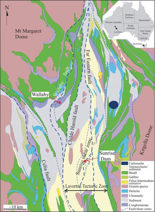
Figure 1 Simplified geological map of the Laverton region (Zhang et al., 2013). Insert shows the location of the region.
According to (Williams and Whitaker, 1993) the Laverton domain have extensive areas of layered gneissic and migmatitic rocks which flank the interior domes. Also (Williams and Whitaker, 1993) anticipated that several of these early shears in the central segment of the Province are indeed major extensional structures related to the evolution of regional gneiss and granite domes. Strain conditions in the boundary zones indicate that emplacement of the gneiss domains to the crustal level of the surrounding lower-grade greenstones was initially along relatively gently-dipping shear zones which were active during uplift. Structural relationships around both the domal granitic complexes and the later granite batholiths, however, show that regional shortening deformation events were not caused directly by the emplacement of any of the granitic rocks.
Rocks at the margin of the Laverton magnetic domain are strongly sheared, intercalated felsic porphyry and amphibolite, the margin forming a primary regional mylonite zone which affects the surrounding greenstones.
Metamorphism
In middles of the Laverton, greenstone belts have undergone low-grade greenschist-facies metamorphism, whereas areas adjacent to granitoid plutons and the margins of belts bordering major granitoid and/or gneiss complexes have experienced higher grade contact and regional metamorphism, respectively (Salier et al., 2005). The metamorphic conditions of the boundary rocks imply that the sheets were intruded at a middle crustal level(Williams et al., 1989; Williams and Whitaker, 1993). A narrow zone of amphibolite – facies regional metamorphism surrounds the greenstones, and the northeastern boundary of the LGB abuts a thin belt of pyroxene- and hornblende – facies contact metamorphism (Salier, 2003), fig2.
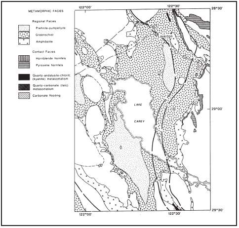
Figure 2 Metamorphic facies distribution for the LGB. Metamorphic grade distribution is similar to those of the Yilgan Craton (Salier, 2003).
Ore-forming processes for gold deposits
Laverton greenstone belt (LGB) gold deposits from the northeast of the Eastern Goldfields province of the Yilgan Craton are found near to or hosted by granitoids (Salier et al., 2005). Though according to (Salier et al., 2005) it was controversial at the beginning on determining the auriferous fluids source of whether from the granitoids or they acted like structural traps controlling the habitation of the deposits. There is a high similarity in redox conditions and mineralisation temperatures for all gold deposits in the Laverton greenstone belt indicating they are genetically related. The similarity in age of these four deposits, as well as previously published ages for the Wallaby (2650 ± 5 Ma) and Sunrise Dam (2654 ± 8 Ma), places three significant constraints on the source of auriferous fluids in the Laverton greenstone belt. Different ideas supporting the single fluid source has been consistent with the age of gold mineralisation in the Laverton greenstone belt. The Wallaby and the Granny Smith gold deposits are not the same age as adjacent granitoids, ruling out the exposed granitic rocks as a proximal magmatic fluid source.
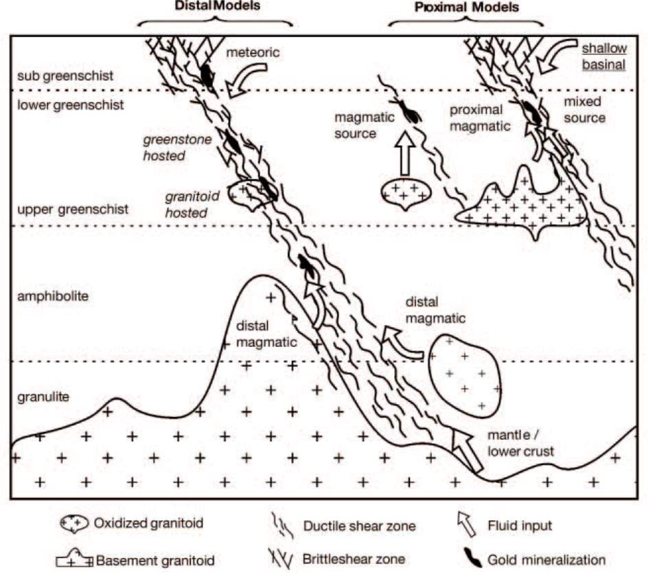
Figure 3 Schematic representation of proximal and distal models for gold deposits in the Eastern Goldfields province. Distal
models involve a deep-seated metamorphic or magmatic fluid, whereas proximal models invoke mid- to upper crustal
granitoids as a vital source of gold-bearing fluids. Adopted from (Salier et al., 2005)
Deposit Styles
Wallaby gold deposit
The Wallaby Gold deposit situated 25km southwest of Laverton within the Eastern Goldfields Province of Western Australia. Wallaby is a major gold deposit of the St Ives Goldfield of Western Australia, with 8 million ounces of an estimated resource of gold.
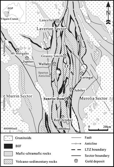
Figure 4 Simplified geological map of the Laverton Greenstone Belt ( adopted from (Sung et al., 2009), showing the sectors and the position of Laverton Tectonic Zone (LTZ) that hosts the majority of gold deposits in this area, including Wallaby Granny Smith and Sunrise Dam. Inset: the position of the area shown in the map (rectangle) in the Yilgarn Craton and Eastern Goldfield Province (EGP)
Host rocks and Proximity to the intrusive rocks
Gold mineralisation is hosted within a mafic conglomerate, intruded by a south-plunging magnetite-actinolite-epidote-calcite altered syenite pipe (Banaszczyk et al., 2015). The Wallaby conglomerate is covered by laminated, fine-grained, clastic sedimentary rocks several hundred metres stratigraphically above the Wallaby gold deposit. The conglomerate intruded by an apparently comagmatic alkaline dyke suite displaying increasing fractionation through mafic-monzonite, monzonite, syenite, syenite porphyry to late-stage carbonatite (Salier et al., 2004).
Ore body structural controls
The structural control on gold mineralisation of Wallaby gold deposit is summarised by(Salier, 2003) in order of scale. At district level it is located in the Laverton tectonic zone, locally it is in chatterbox and Wallaby shear zones. On the mine scale it is in competency contrast of brittle actinolite – magnetite alteration pipe versus least altered conglomerate.
Alteration and mineralisation styles
Gold alteration overprints all rock types at the Wallaby gold deposit. It is commonly hosted by actinolite-magnetite-epidote-calcite (AMEC) altered conglomerate, although chlorite-altered conglomerate also hosts ore in place. The Wallaby conglomerate has been regionally pervasively chlorite – calcite – altered and has been overprinted by greenschist facies metamorphism (Salier et al., 2004; Salier et al., 2005) fig.1.
Granny Smith gold deposit
The Granny Smith gold deposit situated approximately 20km south of Laverton in the central northern part of the Laverton Tectonic zone (LTZ), fig 4. The deposit situated on the eastern margin of the Granny Smith granodiorite (GSG). Gold is hosted at the contact between the granitoid and a surrounding turbiditic rock package (Salier et al., 2004). The deposit is estimated to contain 74t Au at an average grade of 1.63g/t.
Host rocks and proximity to intrusive rocks
The Granny Smith gold deposit is hosted in sedimentary rocks comprising of argillites, arenite, lithic greywacke, conglomerate, BIF, chert and carbonaceous shale beds. Debris flow and turbidite currents responsible for sedimentation derived from andesitic volcanic rocks.
The Granny Smith pluton is zoned calc-alkaline magnetite bearing diorite to granite. Porphyry and uplite pegmatite dykes are common throughout the deposit. Other minor intrusions are carbonatite and lamprophyre dykes.
All ore zones form adjacent to granitoid bodies. The high-grade zones are noted to be at the igneous, sedimentary contact; in some parts localised in shear zones in small diorite sills.
Ore body structural controls
The Granny Smith gold deposit is aligned in the central part of the northern section of N-S striking Laverton Tectonic Zone (LTZ). (Salier et al., 2005) Ascribed the deposit and the regional – scale shear zones to be continuous and not affected by the post mineralisation deformations. The sequence of historical deformation events for the Granny Smith deposit area is as follows: – D1 was isoclinal folding in BIF, reverse faults with minor back thrust; D2 N-S fabric. Regional rotation of greenstone belt; D3 broad E-W compression, which is a reactivation of D1 thrusts, shearing parallel to dykes and pluton margins and gold mineralisation. All the ore zones in the Granny Smith deposit hosted in the N- striking shear zone in contact with the granitoids.
Alteration and mineralisation styles
(Salier et al., 2004; Salier et al., 2005) Describes two stages of gold mineralisation at Granny Smith; early gold mineralisation associated with haematite alteration and later gold mineralisation related to sericite-carbonate alteration. Granitoid hosted gold related alteration is related to networks of fracture controlled brecciated carbonate – quartz veins. Proximal gold related alteration is typically bleached by ankerite – sericite -pyrite- albite +/- chlorite alteration. In sedimentary rocks, proximal gold mineralisation is related to sericite – ankerite- silica-pyrite albite assemblage.
Sunrise Dam gold deposit
The Sunrise Dam gold deposit is located 50km south of Laverton in the central eastern part of the Laverton Tectonic zone (LTZ), fig 1&4. The deposit is considered to contain over 300t of gold at an average of 4.1g/t (Salier et al., 2004). It is considered to be the largest deposit in the Archaean Laverton Greenstone Belt (Eastern Goldfields Province, Yilgarn Craton, Western Australia) (Sung et al., 2009).
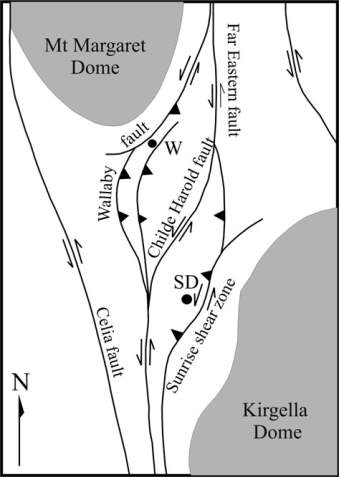
Figure 5 Schematic diagram illustrating the plan-view structural outline of the Laverton region, as adopted from (Zhang et al., 2013). The Wallaby fault and Sunrise Shear Zone are two major fault splays flanking the Childe Harold fault and Far Eastern fault (northern segment), forming a fault restraining step-over structure.
Host rocks and proximity to intrusive rocks
The Sunrise Dam gold deposit is hosted by the sedimentary package which faces upward. The strata at the deposit are classified into hanging wall and footwall sequences above and below the sunrise shear zone respectively (SSZ) Fig.3. The footwall sequence is comprised of lower coarse-grained volcaniclastic unit overlain by a thick turbiditic BIF and siltstone assemblage. Concordant microdiorite sills intrude the turbiditic assemblage which terminates at the SSZ hence missing in the hanging wall sequence. The hanging wall is composed of the massive sequence of volcaniclastic rocks. Rhyodacite dykes intrude the host-sequence through out the deposit. E-W trending lamprophyre dykes also intrude the deposit sequence(Salier, 2003).
Most ore is in BIF-host with some being in volcaniclastic rhyodacite and ultramafics. The rocks in the deposit have been overprinted by lower greenschist metamorphism.
Gold mineralisation spatial relationship to intrusive rocks has been identified close to pre-gold mineralisation rhyodacite dykes. Granitoids outcrop in several places within the deposit and both spatially related to minor gold mineralisation
Ore body structural controls
Gold mineralisation at Sunrise Dam is spatially associated with both BIF and rhyodacite dykes and are consistent with strong structural controls on gold mineralisation. Gold mineralisation in the Sunrise Dam is interpreted to be syn-D2 deformation (Salier, 2003).
Alteration and mineralisation styles
Mineralisation in the Sunrise is characterised by disseminated low-grade ore, hosted in folded and deformed quartz-carbonate veins. In the Sunrise shear zone quartz-carbonate and associated dolomite-sericite-albite-pyrite altered wall rock, host gold mineralisation. Gold-related alteration is zoned, progressing from intermediate dolomite – chlorite – pyrite +/- sericite alteration to broad distal calcite chlorite alteration zones.
Discussion
Gold mineralisation in the Laverton greenstone belt as noted from the Wallaby, Granny Smith and Sunrise Dam is controlled by structures, lithological composition and alteration of host rocks.
Structural styles
A mixture of different fault types comprises these mineralized fault-shear networks within the same gold field, although thrust and reverse faults are a common component of the richer deposits(Micklethwaite, 2007). Features of gold mineralisation in the LGB spatial distribution describes two forms which relate to both regional scale and shear zone. These are spaced, cluster like distributions and linear trends of deposits. This style of clustered distribution of gold mineralisation adjacent to large-scale shear zones or faults is as noted from many other greenstone belts. This cluster like distribution of deposits in the belt represented by the Wallaby, Granny Smith and Sunrise Dam. The LGB studies indicate that the structural deformations attributed by distinct contractional and transpressive phases like that of the Kalgoorlie terrane. The deformation sequence is thought to involve an early stage of nappe-style recumbent folding and thrusting which did not develop pervasive fabrics (Micklethwaite, 2007).
Looking at the structural controls for gold mineralisation on the assessed deposits of Wallaby, Granny Smith and Sunrise Dam; according to (Salier et al., 2005) Wallaby deposit which hosts 220 t of gold at 3.3g/ t, gold hosted in stacked series of thick sub-horizontal brittle fracture lodes. At the Sunrise Dam which hosts 230t at 4.1g/t is hosted in early-lower grade shear -hosted gold and later higher grade in pressure shadows of rhyodacite dykes. Either, at the Granny Smith, the deposit which hosts 74t at 1.65g/t is hosted in the north-south striking shear zone.
Lithological hosts characteristics
According to (Salier et al., 2005) it is noted that the Wallaby gold deposit in looking at its proximity to intrusive rocks; the deposit is located in polymictic conglomerate around syenite dyke suite, but the syenite suite itself is none mineralised. In the Sunrise Dam deposit (Brown et al., 2002) and (Salier et al., 2005) when compared to Wallaby lithological setting it is spatially associated with rhyodacite dykes which intruded the BIF, volcaniclastics and turbidite sequences for gold mineralisation. The rhyodacite dykes these are several small granitoid plutons with 1- 4 km mafic suites. Either, the Granny Smith gold deposit, gold mineralisation is found to be localised at the boundary of granodiorite pluton which are mafic suites and/or turbiditic sedimentary rocks (Ojala, 1997; Salier et al., 2005).
Characteristic alteration styles of deposits alteration
Looking at the alteration proximal and distal to the deposits every deposit is noted to have some similar and different alteration effects. The Wallaby deposit as examined by (Salier et al., 2004; Salier et al., 2005) have dolomite-albite-sericite-silicate-muscovite-fuchsite and pyrite as proximal alteration; while distal alteration is noted with dolomite-sericite-albite- quartz-pyrite. (Brown et al., 2002) and (Salier et al., 2004; Salier et al., 2005) described Sunrise Dam deposit to have dolomite-ankerite – sericite-albite- pyrite as proximal alteration, while distal is noted to be dolomite-chlorite-sericite-pyrite altered. Either, the Granny Smith deposit proximal alteration is predominantly of calcite-sericite-albite- pyrite for granitoids and sericite-ankerite-quartz – albite -pyrite for syenite intrusives. Distal alteration dominated by sericite – chlorite- calcite for granitoids and sericite-chlorite-calcite for syenite intrusives, indicating that distal alteration had same alteration effect(Ojala, 1997).
Conclusions
- Gold mineralisation was broadly contemporaneous with metamorphism, deformation and granitoid intrusion;
- The more intensely faulted and sheared parts of the LGB host high-grade mineralisation deposits like the Wallaby and Sunrise Dam compared to moderately to lowly deformed parts
- Alteration assemblages are retrograde with respect to peak metamorphism;
- Deposits are structurally controlled, epigenetic and most formed about 2625 to 2640Ma;
- There is a possible relationship between granitoids and gold mineralisation.
References
Banaszczyk, S., Wallace, Y., Dentith, M., 2015. Constrained Magnetic Modelling of the Wallaby Gold Deposit, Western Australia, ASEG Extended Abstracts 2015: 24th International Geophysical Conference and Exhibition. Australian Society of Exploration Geophysicists, pp. 1-4.
Brown, S.M., Fletcher, I.R., Stein, H.J., Snee, L.W., Groves, D.I., 2002. Geochronological constraints on pre-, syn-, and postmineralization events at the world-class Cleo gold deposit, Eastern Goldfields Province, Western Australia. Economic Geology 97, 541-559.
Micklethwaite, S., 2007. The significance of linear trends and clusters of fault-related mesothermal lode gold mineralisation. Economic Geology 102, 1157-1164.
Morey, A., Weinberg, R., Bierlein, F., 2007. The structural controls of gold mineralisation within the Bardoc Tectonic Zone, Eastern Goldfields Province, Western Australia: implications for gold endowment in shear systems. International Journal for Geology, Mineralogy and Geochemistry of Mineral Deposits 42, 583-600.
Ojala, V.J.M., N.J.; Groves, D.I.; Ridley, J.R.; Fanning, C.M., 1997. The Archaean Granny Smith gold deposit, Western Australia: age and Pb-isotope tracer studies. International Journal of Geology, Mineralogy and Geochemistry of Mineral Deposits 30, 75-89.
Salier, B.P., 2003. ‘The timing and source of gold-bearing fluids in the Laverton greenstone belt, Yilgan Craton with emphasis on the Wallaby gold deposit’, School of Earth and Geographical Sciences. The University of Western Australia.
Salier, B.P., Groves, D.I., McNaughton, N.J., Fletcher, I.R., 2004. The world-class Wallaby gold deposit, Laverton, Western Australia: An orogenic-style overprint on a magmatic-hydrothermal magnetite-calcite alteration pipe? Mineralium Deposita 39, 473-494.
Salier, B.P., Groves, D.I., McNaughton, N.J., Fletcher, I.R., 2005. Geochronological and stable isotope evidence for widespread orogenic gold mineralization from a deep-seated fluid source at ca 2.65 Ga in the Laverton Gold Province, Western Australia. Economic Geology 100, 1363-1388.
Standing, J.G., 2008. Terrane amalgamation in the Eastern Goldfields Superterrane, Yilgarn Craton: Evidence from tectonostratigraphic studies of the Laverton Greenstone Belt. Precambrian Research 161, 114-134.
Sung, Y.H., Brugger, J., Ciobanu, C.L., Pring, A., Skinner, W., Nugus, M., 2009. Invisible gold in arsenian pyrite and arsenopyrite from a multistage Archaean gold deposit: Sunrise Dam, Eastern Goldfields Province, Western Australia. Mineralium Deposita 44, 765.
Williams, P.R., Nisbet, B.W., Etheridge, M.A., 1989. Shear zones, gold mineralisation and structural history in the Leonora district, Eastern Goldfields Province, Western Australia. Australian Journal of Earth Sciences 36, 383-403.
Williams, P.R., Whitaker, A.J., 1993. Gneiss domes and extensional deformation in the highly mineralised Archaean Eastern Goldfields Province, Western Australia. Ore Geology Reviews 8, 141-162.
Zhang, Y., Schaubs, P.M., Sheldon, H.A., Poulet, T., Karrech, A., 2013. Modelling fault reactivation and fluid flow around a fault restraining step‐over structure in the Laverton gold region, Yilgarn Craton, Western A Australia. Geofluids 13, 127-139.
Cite This Work
To export a reference to this article please select a referencing stye below:
Related Services
View all


Related Content
All TagsContent relating to: "Geology"
Geology is an “Earth science” or “geoscience” concerned with the study of the physical structure of the Earth (or other planetary body) and the rocks of which it is made, the processes that shaped it and its physical, chemical and biological changes over time.
Related Articles

DMCA / Removal Request
If you are the original writer of this dissertation and no longer wish to have your work published on the UKDiss.com website then please: