Geological History of The Western Algarve, Lagos - Portugal
Info: 11675 words (47 pages) Dissertation
Published: 9th Dec 2019
Tagged: Geology
The Geological History of The Western Algarve, Lagos – Portugal
Table of Contents
Chapter
- Abstract………………………………………………………………….………….…………7
- Introduction………………………………………………………….………..…….…….9
- Literature Review……………………………………………………..……….……..12
- Methodology………………………………………………………………..……….…….13
- Description of the Lithologies Mapped……….…………………………14
5.1 Sedimentology…………………………………………………………………………14
5.1.1 Calheta Formation……………………………………………………….……14
5.1.1.1 Fossil Assemblage………………………………………………….….17
5.1.1.2 Depositional Environment……………………………….………..18
5.1.2 Luz Formation………………………………………………..…………………18
5.1.2.1 Mudstone…………………………………………………….………………20
5.1.2.1.1 Fossil Assemblage………………………………………………..20
5.1.2.1.2 Depositional Environment…………………….…………….21
5.1.2.2 Marl……………………………………………………………………..………21
5.1.2.2.1 Depositional Environment……………………………….…..21
5.1.2.3 Sandstone……………………………………………………..……………22
5.1.2.3.1 Depositional Environment……………………………………23
5.1.3 Moz Formation………………………………………………………….……….24
5.1.3.1 Marl…………………………………………………………………………..…25
5.1.3.1.1 Depositional Environment……………………….…………..26
5.1.3.2 Limestone……………………………………………………………………26
5.1.3.2.1 Fossil Assemblage……………………………….……………….27
5.1.3.2.2 Depositional Environment………………………………..….28
5.1.4 Ponta da Piedade Formation………………………………………………….29
5.1.4.1 Limestone……………………………………………………….……………30
5.1.4.1.1 Fossil Assemblage……………………………………….………..30
5.1.4.1.2 Depositional Environment………………………….………….31
5.2 Igneous Rocks…………………………………………………………………….……32
5.2.1 Pedra Negra……………………………………………………………….………32
5.2.2 Dykes…………………………………………………………………………………34
5.3 Metamorphism………………………………………………………………………….36
6. The Structure of the Area…………………………..……………………………..37
6.1 Brittle Deformation…………………………………………………………………..37
6.2 Regional Context and Interpretation……………………………..………..38
- Dyke emplacement……………………………………………………….……………….39
7. Geological History…………………………………………………………………….…40
7.2 Summary of the Geological History in Lagos………………………………..46
8. Conclusions……………………………………………………………………………………47
Appendices…………………………………………………………………………….…………48
References………………………………………………………………………………….…….49
List of Figures and Tables
Figure 1.1- Mapping Area Locality…………………………………………..…………..9
Figure 5.1- Sedimentary Log Calheta-Luz Beach……………….……………..15
Figure 5.2- Cross Bedding, Calheta Sandstone…………………….……………16
Figure 5.3- Nerinea Gastropod………………………………………..………………….17
Figure 5.4- Praia da Luz………………………………………………………………………19
Figure 5.5- Luz Formation Cliff…………………………………………………………..19
Figure 5.6- 1: Gastropod; 2: Ostracod……………………………………….………21
Figure 5.7- Carbonised Plants………………………………………….…………………22
Figure 5.8- Luz Sandstone Thin Section……………………………………………..23
Figure 5.9- Sedimentary Log Porto do Moz…………………….………………….24
Figure 5.10- Normal Faults…………………………………………….……………………25
Figure 5.11- Ammonite……………………………………………………………………….26
Figure 5.12- Calcium Carbonate Precipitated Crystals……….………………27
Figure 5.13- Sedimentary Log Dona Ana Beach………………………………..29
Figure 5.14- A: Echinoderm; B: Bryozoan; C: Bivalves…………….……….30
Figure 5.15- Sketch of Moz – Piedade Unconformity………………….………31
Figure 5.16- Ponta das Ferrarias (Pedra Negra).………………………………..32
Figure 5.17- Cross Section Luz-Porto do Moz…………………………………….33
Figure 5.18- Hand Specimen, A: Pedra Negra; B: Dyke………….………..33
Figure 5.19- Thin Section. A: Pedra Negra; B: Dyke………………………..34
Figure 5.20- Stereonet, Dykes and Faults………………………………………….35
Figure 5.21- Pedra Negra…………………………………………………………………….36
Figure 6.1- Drag Folds………………………………………………………………………..37
Figure 6.2- Stereonet, Faults……………………………………………….…………….38
List of Tables
Table 7.1- Tectonostratigraphy………………………………………………….……….43
Table 7.2- Summary of Geological History………………………………….………46
Chapter 1
Abstract
Present in this report is the account of the geology, structure and stratigraphy of Western Algarve. Formations encountered within the mapping area range in from Lower Cretaceous up to Neogene (Miocene). The rocks are mostly sandstones, mudstones, marls and limestones laid horizontally one on top of the other with dip angles ranging from 5 to 15 degrees.
The Algarve basin, approximately 8000km2, is located in the south of Portugal and extends onshore and offshore parallel to the coastline. The rocks in mapping area have undergone brittle deformation which originated in a series of small normal faults, most of them trending North-South.
Intruded in the Luz and Moz formations, is a volcanic plume, Pedra Negra (Black Stone) and numerous dykes. Most of these dykes have the same orientation as the normal faults in the cliffs. Contact metamorphism caused by the intrusions caused alteration in the sedimentary rocks, causing them to lose some of their sedimentary properties and features.
Ponta da Piedade formation, the youngest sedimentary rocks of the basin, are made up 90% by fossils cemented together by calcite cement. The geomorphological features and the rugged outlook of the cliffs in this area are an evidence of excessive erosion and sediment karstification.
The rocks in the mapping area started being deposited during the Lower cretaceous, however, the distension which caused the normal faults, and the dykes are related to tectonic events during the Upper Jurassic.
Sea level changes and tectonics played important role in the deposition of the sediments in the Algarve basin. They caused constant change in depositional environment, from deep and shallow marine, lagoonal and reef environments, and bringing to the shore terrigenous content. More importantly on a larger scale, the tectonic events gave origin to Bays and Gulfs around the Iberian Peninsula, the opening of the Tethys Ocean and the divergence between Africa and Europe.
Chapter 2
Introduction


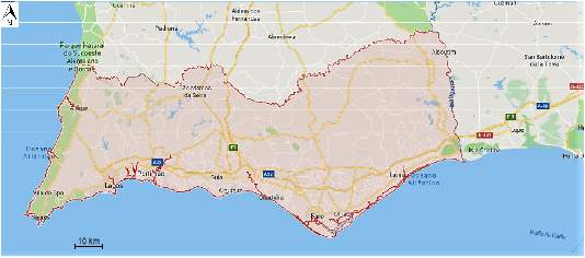
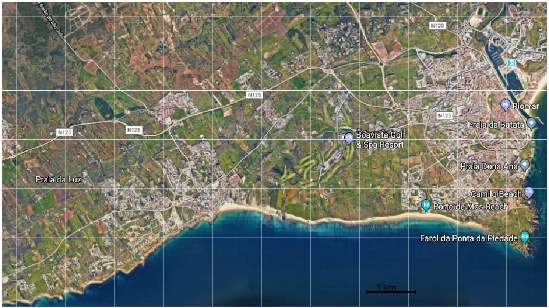
Figure 1.1: Location of Mapping Area (shown in the red rectangle) Sourced from Google Maps.
The document presented is a report of geological fieldwork carried out during the summer 2017 in Lagos, Western Algarve (figure 1.1). The project concentrated on and around the Lagos and Luz Beach area, where previous works have failed to address the detailed geological implications and history. The area is composed of rocks ranging in age from Lower Cretaceous to Miocene. In this report, the chapter 3 contains a review of the relevant literature. The methods used in the realisation of the study were then described in Chapter 4, after which the Lithologies were described and discussed in Chapter 5. The structure and deformation of the basin was analysed and discussed in chapter 6, followed by the geological history and summary, and main conclusions of the study area, outlined in chapter 7 and 8 respectively.
The objectives of the field work and the dissertation are to identify and define lithological units in the area; Interpret the geology of the basin, determine the environment deposition and period of deposition; Deduce deformation history from structural relationship.
The Algarve Continental Margin is located on the southern front of mainland Portugal and together with the Southwestern margin of Spanish constitutes the northern edge of the Gulf of Cadiz. It is limited to the east and northeast by the Spanish Gulf of Cadiz and the Guadalquivir, to the south by the Banco de Guadalquivir and the Allochthone Unit of Guadalquivir, and to the west by cables of São Vicente and Sagres. The morphology of the Algarve basin is a reflection of a geological evolution controlled by tectonics and sedimentary dynamics.
The Lower cretaceous rocks of the Luz and Moz Formations were gently overlaid by the massive fossiliferous Miocene sedimentary rocks, and cross cut by volcanic intrusions, a series of dykes and mineral veins. The oldest rocks encountered in the mapping area are the brown Sandstones of the Calheta formation, they dip gently to South East and are overtaken by the Luz formation at Luz beach. A series of normal faults were also visible in the cliffs of Luz and Porto do Moz beach, the faults have a general dipping trend to north East and have.
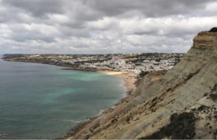
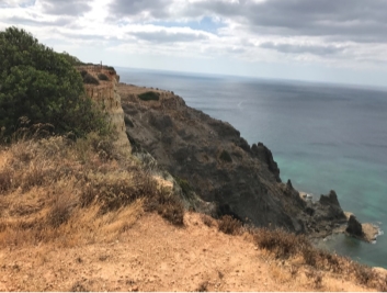
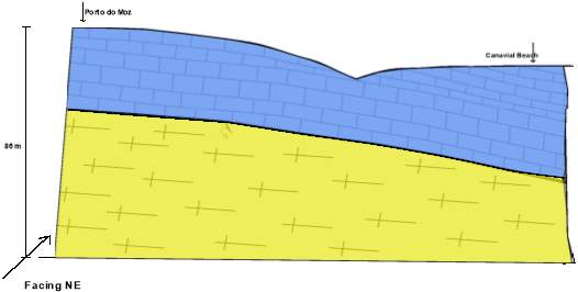
The fossil rich limestones (Ponta da Piedade formation), to East of the mapping area, between the beach of Porto do Moz and Beach of the Rock are constituted essentially by fossil with carbonated cement. This rock emerges mainly along the coast, constituting a platform whose average altitude is between 50 and 60 m. The marine erosion acting on this formation has originated beautiful morphological features, such as caves, arches, stacks and stumps, visible in Ponta da Piedade. Among the abundant macrofauna of the limestones prevail the bivalves, Bryozoan and Echinoderms.
The mapping area is a 21km² section of mostly flat surface and beach cliffs due to its coastal geography and human intervention for tourism. Most of the accessible outcrops were located at the coastal area, due to high amount of construction work taking place in the area. The topography ranges from sea level to approximately 110 meters and is not cross cut by rivers or streams.
Accessibility to the beaches was largely good due to good public transport and to the presence of walking paths, with the main issues being barbed wire fences in inaccessible private land. There were no problems related to vegetation cover because the land was dry and most of the vegetation was dead, however, there was a lot of soil, approximately 1 meter thick, covering the outcrops, most of it placed by humans for construction purpose.
Chapter 3
Literature Review
The geology of the Iberian Peninsula and the has been studied extensively by many authors. However not so much has been published on the geology of Algarve until the present day.
Among the researches on the tectonics and stratigraphy of the Algarve are those of Bonnet (1950), Choffat (1887), Pratsch (1958), and more recently, Rocha (1976), who was very interested in the stratigraphy and paleontology of the Jurassic of the Western Algarve. Moreover, there have been a noticeable increase in the studies of the Geology and Stratigraphy of the Algarve. For example, the researches of Palain (1976), on the basic units of the Mesozoic, Marques (1983), which focus on the Oxfordian and Kimmeridgian of the Eastern Algarve, Antunes et al. (1981) who review the Algarve Miocene and proposed new units, Berthou et al. (1983) and Rey (1983) that synthesize current knowledge on the Cretaceous stratigraphy of the Algarve. Lautensach (1937), Gouveia (1938) and Feio (1951), works dealt with the morphology of the Algarve and it also includes references to geology and tectonic Algarve.
The Center of Geology of the University of Lisbon have carried out researches which contributed to a better knowledge and understanding of the Algarve Geology. Among these works are: The discovery of important volcano-sedimentary episodes (Romariz et al., 1976, Romariz et al., 1979); New facies of the Miocene (Romariz et al., 1979), The discovery of a vertebrate deposit and its importance on dating the Miocene formation (Romariz et al., 1979); and A post-tectonic Palaeozoic formation (Almeida e Carvalho, 1983).
Chapter 4
Methodology
Geological mapping was performed on six 1:10000 scale military base maps bought from the Portuguese military ministry, then edited using Corel draw. To map the area was used the green line mapping method, which involves drawing to scale on base map exposure bubbles bordered by a green line, using a 1mm pen. The varying lithologies determined the colours of the exposure bubbles. Transect mapping techniques, which involves marking observed lithologies along a pre-determined route, and boundary mapping, was also used, especially on the coast to determine the boundaries between Luz and Moz formations, and Moz and Ponta da Piedade formations. However, the technique was not so efficient on following the lithologies inland because of path disruptions due to habitations in the area. Google Map and aerial photographs, as well as photographs from literature, were employed to examine the mapping area before mapping initiated.
For structural data collection, a compass clinometer was used to collect strikes and dips using the right hand rule, rock samples and field photographs were collected, and further observations of the rocks, and field sketches were recorded in 2 waterproof field notebooks.
Two 1:25000 scale Military Maps of Portugal (Lagos Sheet 602 and Portimao sheet 603, edition 3, year 2005), bought on the Military Geographic institute, a Geographical Positioning System (GPS) as well as Aerial Photographs were utilised to assist mapping. These helped mapping by facilitating self location and mapping planning, mainly mapping inland because they showed possible roots, uninhabited areas were outcrops could be exposed, particularly the Luz formation which had a vast unoccupied area were outcrops could be traced.
Mapping was done over a course of 28 days, with periodic breaks in regular intervals over the period. Eighteen of the 28 days were dedicated solely to mapping and the remained 10 days to general geological investigation, sedimentary logging and structure analysis. During the entire stay, a Riomar Hotel in Lagos Old Town served as accommodation.
Chapter 5
Description of the lithologies mapped
The Algarve basin is made up mostly by carbonate sedimentary rocks and some clastic rocks. Four sedimentary formations have been identified in the mapping area, based on characteristic form and composition where appropriate they are subdivided into different member lithologies. Interpretation of the likely depositional environment are made at the end of each sub-section.
The main lithologies mapped are: a unit of gray, green or violet mudstones, marls, fine sandstones, marly limestones and limestones crop on the coast. An igneous intrusion has plummeted to the surface on the eastern side of Luz beach, and a series of dykes have cross cut both Luz and Moz sedimentary formations. The rocks close to these Vulcanic bodies, mainly at Luz beach, have undergone low grade metamorphism which caused them to lose some of their sedimentary characteristics.
5.1 Sedimentology
5.1.1 Calheta Formation
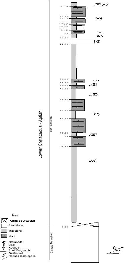
Calheta formation is the western most formation of the mapping area, and it is conformably overlaid by Luz formation at East (figure 5.1, sedimentary log) and underlaid by Burgau formation. The formation is part of the Luz Super Group, deposited during the lower Cretaceous, and its thickness ranges from 10 to 18 metres.

Luz Formation
Interbedded Mudstones (purple, grey and red), marl and sandstone (cross bedding and horizontal lineation).
Calheta Formation Sandstone
Fine to medium grained, cross bedding, Herringbone stratification and parallel lineation.
Figure 5.1: Stratigraphic log of Calheta – Luz Beach Formations
Calheta sandstone is characterized for its fine to medium grain size, up to 01mm, laid almost horizontally with dip angles varying from 02 to 10 degrees with direction South to South west. These sandstones show cross bedding and Herringbone stratification (figure 5.2), and the overall thickness of the formation does not exceed 20m. Some layers in the beds are almost or entirely made up of gastropods fossil of the Nerinea specie, and they have a North-South and Southeast-Northwest orientation.
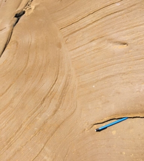
Figure 5.2: Shows horizontal lineation and cross bedding in Calheta sandstone.
Microscopic and in situ analysis show that this sandstone is composed mostly by grains of quartz, cemented by calcite. The grains are mostly mature because they show roundness and are mostly very well sorted. There is no great difference in the grain size of the particles, except for one or two grains. This suggests that the sediments have travelled a long way from their source, which allowed them to be weathered and acquire the round shape.
5.1.1.1 Fossil assemblage
The fossils occur in the sandstones as beds intercalated in non-fossiliferous beds of the same sandstone. They are very well preserved in the beds and are a great indicator of time and depositional environment of the rocks.


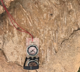
Figure 5.3: Nerinea gastropods in Calheta sandstone bed. Axis aligned North-South and Southeast-Northwest.
Nerinea gastropods (figure 5.3) possess a tight tower shell and they were found in the sublittoral zone, up to 200m depth, unlike other type of gastropods, Nerinea snail moved around to find food, straining out small particles of food from the water passing over them, because they are suspension feeders or filter feeders. They were present during the Jurassic and Cretaceous periods.
In Calheta sandstone beds close to Luz beach (grid refernce:24013 04332), the Nerinea fossils are aligned mostly southeast-northwest, this tells about the paleocurrents. During the deposition of these sediments, water was moving in the same direction as the fossils orientation.
- Depositional Environment
Calheta sandstone are medium to coarse grained, indicates that the fluid moving the sediments had moderate to high energy to move the coarse grains, and the fossils. The cross bedding and Herringbone stratification in the rocks suggest uni-directional tidal and bi-directional fluid currents caused by tidal streams flow and beach waves respectively. Moreover, the alignment of the fossils gives a hint on the paleocurrents direction during deposition. Because the majority of the gastropods axis are aligned North-South, it can be concluded that the paleocurrents had a North-South direction. Taking all the factors mentioned above into account, it can be concluded that Calheta sandstone was deposited near shore, in beach environment with continental influence.
5.1.2 Luz Formation
Luz formation is the second oldest formation in the mapping zone, deposited just after the Calheta Formation. Luz is made up of intercalated beds of Mudstone, Marls and, and a bed of sandstone. These beds were cross cut by an igneous intrusion which can be seen further East at Luz beach. The rocks are laid gently one on top of the other (figure 5.4 and 5.5), and the dip angles are not greater than 15 degrees with the dip direction Southeast. Luz formation beds still occur at Porto do Moz beach where cliffs are then overtaken by the Moz Formation.

1
2
Figure 5.4: Panoramic view of Praia da Luz, cliff more or less 108 metres high. 1 Mudstone dominated zone. 2 Limestone dominated zone, part of the Porto do Moz formation.

 1
1

 2
2
 1.63m 3
 4
4
 5
5
Figure 5.5: Part of Luz Formation. 1 and 3 – Mudstones beds; 2 and 5 – Marl beds; 5 – Sandstone (GR: 24020 04450).
5.1.2.1 Mudstone
The beds of mudstone are distributed in thin layers of different colour mudstone, such as red, purple and dark and light grey muds. The rocks are fine grained, very crumbly, they break and erode very easily, and show planar bedding.
The variation in the colour of the beds might be due to change in conditions during depositional sediment deposition. The red colour in rocks normally indicates iron oxide precipitation in the environment, whereas the grey colour (darker or lighter) is an indicator of the amount of silica minerals present during the deposition of the bed. No fossils were present in mudstone lower beds of mudstones, only in the upper beds which could be closely analysed further east of Luz beach.
Mudstones close to the igneous intrusion have been subjected to low grade contact and hydrothermal metamorphism. This caused them to lose their sedimentary feature.
5.1.2.1.1 Fossil Assemblage
Along the beach heading east a series of ostracods and shell fragment fossils were well exposed on the mudstone beds (figure 5.6). Gastropods are very well preserved and can be easily spotted close to the igneous intrusion (more or less at GR: 25090 04400), where mudstone beds become massive and less crumbly (figure 5.6) due to low grade contact metamorphism caused by the volcanic body.
Marine ostracods are normally part of the Zooplankton or most commonly belong to the benthos living on or inside the upper layer of the sea floor. They started evolving during the Ordovician period, and some species are still present.
1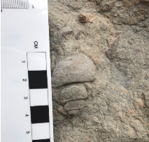 2
2 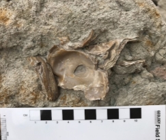
Figure 5.6. Metamorphosed luz mudstone near the igneous intrusion. 1- Very well preserved gastropod fossil, about 4.5 centimetres long; 2- Ostracod shell fragments.
5.1.2.1.2 Depositional environment
The mudstones were deposited in a relatively deep, low energy environment such as lagoonal or littoral marine. This could be concluded by analysing the grain size and colour of the rocks, and from the fossils present. The variation in colour originated from changes in conditions during deposition, the dark grey colour suggests the presence of higher content of silica and clay minerals in the environment.
5.1.2.2 Marl
Marl beds are characterised by a light grey colour and very poorly grain sorting. They are quite hard because as they were not as eroded as the mudstone beds, and the thickness of the beds ranged from 0.10 to 2.10 metres.
5.1.2.2.1 Depositional environment
Luz Marl could be considered Argillaceous Marlstone because they are about made up of 70 % clay and around 20% calcium carbonate. These rocks were deposited in a similar environment as mudstone beds, in a lagoonal brackish waters, relatively shallow marine environment. However, the input of terrigenous clay material was not as high as in the mudstone deposition.
5.1.2.3 Sandstone
A single bed of sandstone cropping out of the cliff, dipping gently towards southeast was deposited between two beds of mudstone. This sandstone differs from Calheta sandstone by its grain size and colour, it is coarser than Calheta, has a paler cream colour and does not have Herringbone cross strata, it also has bi-directional cross bedding and horizontal lineation, not many fossil present, only carbonised plants (figure 5.7). The single sandstone bed had a thickness of approximately 0.70m.
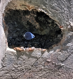
Figure 5.7: Carbonised plants in the sandstone bed
The underclay is a preserved relict of the soil in which the coal-producing vegetation was rooted, and the marine units overlying the coal record the rapid transgression of the sea inland that killed the vegetation by drowning it and preventing its decomposition by rapid burial.
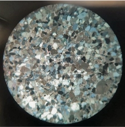
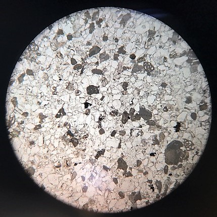
Figure 5.8: Thin section of the sandstone from Ponta da Calheta. Cross polar light (left) and plane polarised light (right). x10 magnification, Cross polar (left); Plane polarised light (right).
Luz sandstone shows a reasonable level of maturation and sorting. The grains are mostly round and have similar sizes, as shown by the thin section (figure 5.8). The most abundant mineral present is quartz (light grey and blue grey, colourless in plane polarised light). The level of sorting and maturation of the grains suggests that the sediments have travelled a long way from their source and undergone severe physical weathering.
5.1.2.3.1 Depositional Environment
It is obvious from the grain size and cross bedding that this sandstone has been deposited in moderate energy waters with bi directional water currents. The carbonised plants indicate that there was continental influence during the deposition. It can be concluded that the depositional environment of the sandstone bed was a beach and factors such as water or wind current have transported the terrigenous content to the sedimentation locality.
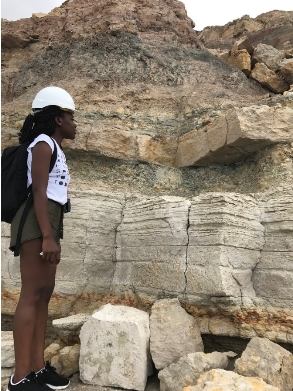
5.1.3 Moz Formation
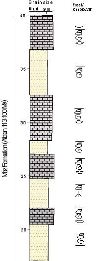
Figure 5.9: sedimentary log of Porto do Moz beach, Moz formation.
Moz formation at Porto do Moz beach is made up of interbedded layers of marly limestone and limestones (figure 5.9). The cliffs have been affected by several small normal faults (figure 5.10) and has been intruded by a couple of dykes that can be seen on the west side of the beach.


Fault downthrow
Upthrow
Fault line
Figure 5.10: Porto do Moz beach cliff (Moz formation), displaying intercalated beds of marl, marly limestones and limestone, and normal faults (GR: 27444 04406).
5.1.3.1 Marl
Porto do Moz Marls are characterised by a cream to yellow colour, bed thickness ranging from a couple of centimetres, up to a metre. The beds are very poorly sorted and have horizontal and inclined burrows. Among the fossils present in these rocks are shell fragments, gastropods and ammonites (figure 5.11). The beds of mars and limestone can be differed from the analysing their rate of weathering. marl beds have a dusty outlook and have been eroded faster than limestones.
Porto do Moz limestone differs from Luz marl by its lime content, while Luz marlstones are argillaceous, Moz are calcareous marls, one becoming cream and the other grey.
5.1.3.1.1 Depositional Environment
Porto do Moz marl differs from Luz marl by the colour and fossil content. According to its composition, Moz marl are calcareous. Their high content of calcium carbonate suggests a carbonate platform type of environment, such as a lagoon. There is not much fossil in the beds because most of it has been decomposed or weathered.
5.1.3.2 Limestone
Moz limestones are characterised by a cream colour, very fine grainsize and high calcium carbonate content. The weathered surfaces on the cliffs show an orange colour and are quite soft, easy to break. Within the fine-grained calcium carbonate cement are series of fossils, such as bivalves, gastropods and ammonites (figure 5.11). These can be easy spotted on the east cliffs of Porto do Moz. The beds thickness ranges from a few centimetres to 4 metres, intercalated by marl.
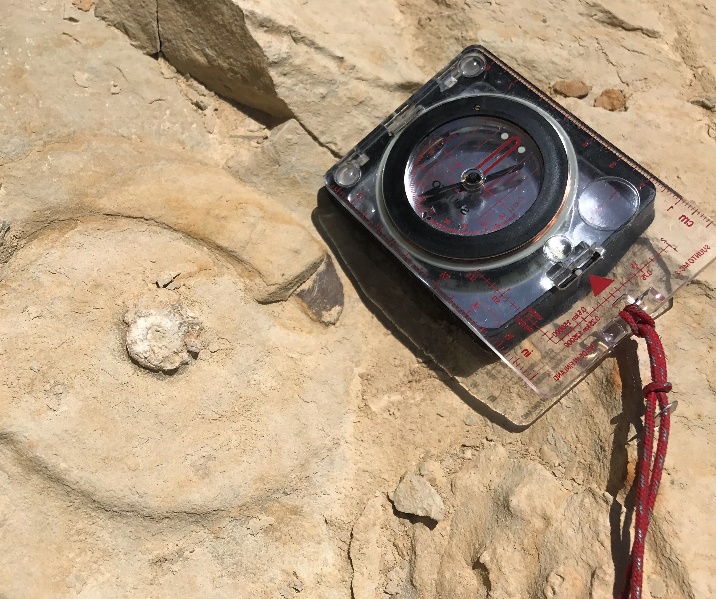
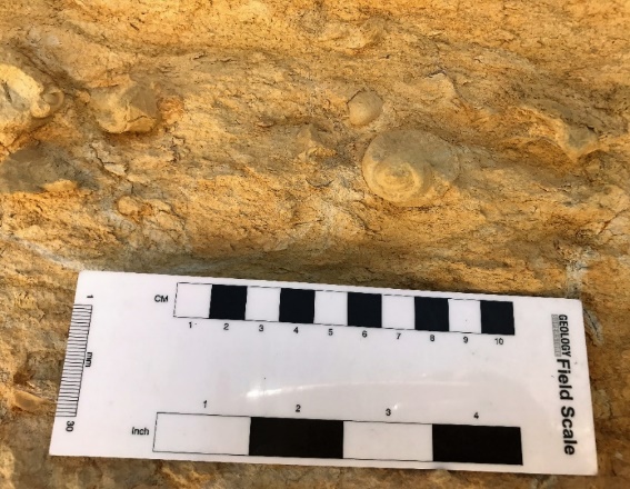
Figure 5.11: Very well exposed ammonite in a weathered limestone bed.
Further east of the beach, where the sea water washes the rocks more constantly, calcium carbonate has precipitated in both limestone and marl (figure 5.12).
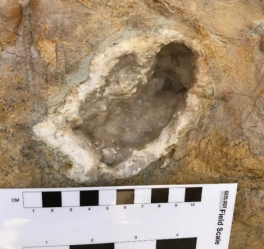
Figure 5.12: Calcium carbonate precipitation in a weathered limestone bed.
5.1.3.2.1 Fossil Assemblage
Molluscs
Marine molluscs have a shell which consists of a hollow cone with numerous rings which represent the successive growth stages of the shell. They possess a mouth, paired gills and gut.
- Ammonite
Ammonites first appeared during the Devonian period and became extinct in the Late Cretaceous on the Cretaceous-Tertiary Extinction event. The ammonites found in the limestones beds had a coiled shell and their sizes ranged between 2 to 3 centimetres across. Most of the ammonoids lived in shallow marine waters and were zooplankton, crustaceous feeders. The shells of the fossils were not present in the rocks, this is because the shells were so soft and deteriorated very fast.
- Gastropods
- Bivalves
Bivalves have been part of the fossil record since the early Cambrian, around 500 million years ago. There are approximately 9000 species. Marine bivalves represent about 8000 species and the freshwater bivalves are divided into seven families. During the Cretaceous, some of these marine species used to build reefs, cementing themselves together as they grew.
The shell of the bivalves is composed of two calcareous valves linked together by a ligament. The majority of bivalves are filter feeders and they use their gills to capture phytoplankton particulate food from the water.
5.1.3.2.2 Depositional Environment
The fossils present in the rock suggest that both Moz limestone and marl were deposited in a Lagoonal brackish environment. However, there must have been a slight change in conditions when one of each was being deposited.
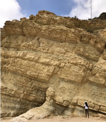
5.1.4 Ponta da Piedade Formation
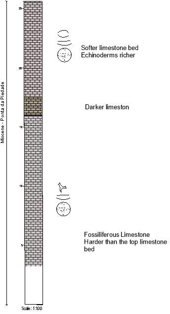
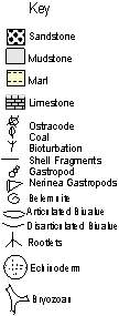
Figure 5.13: Sedimentary log of Dona Ana beach.
The further east of the mapping area it gets, the more fossiliferous the limestone becomes. Ponta da Piedade formation takes over the Lagos coastal cliffs at Canavial beach and extends eastwards until near Meia beach. The cliffs are solely made up by two massive beds of limestones divided by a dark layer of a darker material, approximately 1.25 metres thick (figure 5.13). This darker colour was originated by no sedimentation and water laying on the sediments for a certain period.
5.1.4.1 Limestone
These massive bed of limestone is 90% composed of carbonate material, fossils, cemented together by calcite as they react in presence of hydrochloric acid. The rocks are cream to off white in colour, massively deposited, and they are very hard. The main fossils present in the limestone beds are shell fragments, Bivalves, Bryozoan and Echinoderms (figures 5.14).
5.1.4.1.1 Fossil Assemblage
 A
A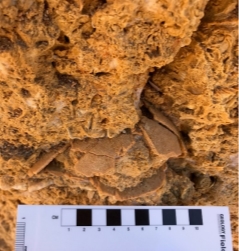
B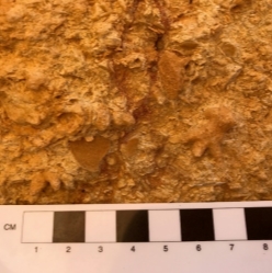 C
C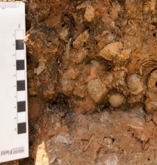
Figure 5.14: Upper bed of Limestone. A: Moderately preserved Echinoderm (Echinoid) fossil; B: Bryozoans; C: Bivalves and shell fragments, weathering has caused its cream colour to change.
Bryozoan species evolved during the Ordovician period, 483.3Ma ago and some are still present. They habit in marine tropical waters and are filter feeders, feed from sieving small particles out of the water.
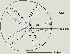
Echinoids
The echinoids present in the limestones were the regular Sea Urchin type. Echinoids are penta-radially symmetrical organisms (figure 5.14, A), they possess a water vascular system and their internal skeleton is made up of calcitic ossicles. Most of them were detritivore feeders and lived in slow moving shallow waters, such as coral reefs. Echinoderm fossil record dates back to Middle Ordovician period.
5.1.4.1.2 Depositional Environment
After the deposition of the Cretaceous units a basin inversion occurred in the Algarve basin which caused the Angular unconformity between the Cretaceous and the Miocene limestones (figure 5.15). This basin inversion was responsible for the change in the environment in the basin.
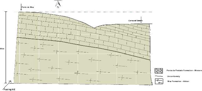
Figure 5.15: Miocene limestones lying unconformably on top of Moz formation of the Albian period.
The Miocene limestones have a very rich fossil content, and there was no continental influence during their deposition. The high carbonate content and the types of fossils present suggest marine reef environment, tropical warm waters, less than 100m deep. Reef environment supports a wealth of calcareous organisms, which can be seen in these limestones.
- Igneous Rocks
5.2.1 Pedra Negra

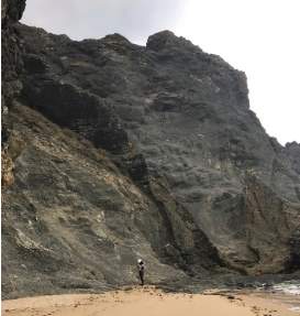
Figure 5.16: Ponta das Ferrarias. Pedra Negra and a dyke cutting through.
At Ponta das Ferrarias (GR: 25160 04425) where the limit between Luz and Porto do Moz beaches is marked, a basic igneous rock has intruded the sedimentary rocks. This volcanic body (figure 5.16) is of Upper Cretaceous age because it cuts through the lower cretaceous sedimentary rocks (figure 5.17) and is related to the Monchique Massif situated North of Algarve. It is characterised by a dark colour with medium to coarse grainsize (up to 200 microns average), and mafic mineralogy.
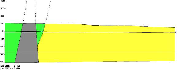
Figure 5.17: Cross section of Luz and Porto do Moz cliffs outlining Pedra Negra cutting through both formations.
Pedra Negra is believed to have been a volcanic chimney which erupted to the surface destroying the rocks existent and assimilating some of it, but not enough to have its composition changed. Xenoliths of varying sizes up to 1 metre can be observed around its body, mainly close to the cliff. Several calcite mineral veins are also present in the sediments of Luz and Moz formations.
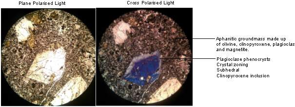
Figure 5.18 – Thin section of Ponta das Ferrarias intrusion (Pedra Negra).
Pedra Negra is a porphyritic basalt, made up of light grey plagioclase, black pyroxene and dark green olivine phenocrysts, up to 3 millimetres long, on a fine-grained groundmass composed of plagioclase, olivine, clinopyroxene and magnetite (figure 5.18). The presence of phenocrysts in the rocks suggests two stages in the cooling of the lava. First the phenocrysts were crystallised under the crust, and then the magma was extruded cooling very fast.
5.2.2 Dykes
A series of Dykes cutting through the cliffs are also believed to be related to the volcanic body (Pedra Negra) and the Monchique Massif. The dykes present a similar colour to Pedra Negra, are fine grained and a massive often jointed structure. Joints were also observed within a dyke close to the massive intrusion (GR: 25152 04430), and some of them were filled with calcite veins.
Petrology and hand specimen analyses shows that the dykes and the Volcanic plume (Pedra Negra) have the same mineralogical composition. Both are made up of mafic minerals, such as feldspar, pyroxene and some olive, with iron minerals making up the groundmass. The only difference was that the Pedra Negra (the big intrusion) has a porphyritic texture with coarser minerals which can be seen with naked eyes and coarser rock feel overall, whereas the dykes have a finer appearance and Aphanitic texture (figure 5.19).
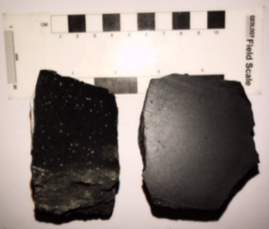
Figure 5.19: Pedra Negra (left) and Dyke specimens.
Both rocks have the same mineralogical composition, but their grain sizes are different. In Pedra Negra, feldspar, pyroxene and Olivine crystals are suspended in the dark, fine grained groundmass. In the dykes however, they are not visible, only with a help of a petrographic microscope. The dykes cooled faster than Pedra Negra and the crystals did not have enough time to grow, hence the aphanitic texture.
Other igneous bodies in the Algarve, which are believed to have the same origin as the intrusions in the mapping area, are found in the North, the Monchique Massif plateau. This plateau of alkali volcanic rocks is part of the Late-Cretaceous Iberian Alkaline Igneous Province. This suggests that the dykes and Pedra Negra are younger than Luz and Moz formations. In addition to that, considering that they cross-cut both lithologies, it can be concluded that the formations are older than the intrusions. Subsequently, the volcanic bodies are the older than Ponta da Piedade formation.
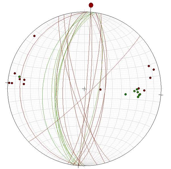
Figure 5.20: Dykes and faults of Luz and Moz beach cliffs.
Most of the dykes at Luz and Moz beaches have more or less the same orientation as the majority of the faults, striking North-South and North-South as shown in the stereonet above (Figure 5.20).
5.3. Metamorphism
There was very little to none metamorphism in the Lagos bay. However, where Pedra Negra evolved, the sedimentary rocks next to it have undergone a low-grade contact metamorphism due to the heat from the igneous body. This hydrothermal metamorphism has caused rocks around the intrusions to lose most of their sedimentary features, the lighter colour (refer to figure 5.21), and capacity to resist erosion. No fabric or foliation are present in these meta-sediments.
 Preserved
sediments
 Metamorphosed
sediments
Figure 5.21: Panoramic view of Pedra Negra. The sediments affected by the contact metamorphism became softer and less resistant to erosion.
Chapter 6
6. The structure of the area
Across Centre Algarve (Lagos), several prominent faults have offset the cliffs causing a slight distention of the coastal area. These faults particularly noticeable in the Luz and Moz formations. Some of them have caused small drag folds in the sedimentary rocks (figure 6.1).
6.1 Brittle deformation
A set of normal faults was observed in the Luz and Moz formations (from grid reference: 24872 04458 to grid reference: 28240 042 270). Most of the faults observed have North-south orientation with, and only one have Northeast-Southwest orientation. This last fault created a big displacement between it and the its closest fault, with approximately 200m.
1 2


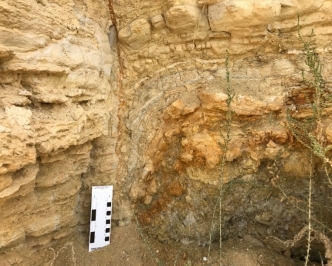
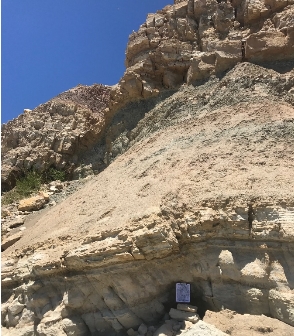
Figure 6.1: Shows normal faults and drag folds. 1 Luz beach, 2 Porto do Moz beach.
Drag folds (figure 6.1) normally occur at shallow crustal depth close to the surface, in soft rocks. The hanging wall have been bent due to the pressure from the downthrow block as it slides down.
The net of displacement of the normal faults at Luz and Moz beaches is typically very small, less than a few centimetres, and their geometry is normally flat. Most of the fault segments show low dips and strikes between 60 to 88 degrees.
According to the cross-cut relationship, these faults are younger than both Luz and Moz formations, and older than Piedade formation. And because there was no sedimentation on the Central Algarve onshore during the Paleogene, they must be of Upper Cretaceous age.
6.1.2 Regional Context and interpretation
The North-South orientation of the faults suggests East-West extension, and the Northeast-Southwest indicates Northwest-Southwest extension (Figure 6.2). There have been tree phases of deformation in the Algarve since the Lower Cretaceous.
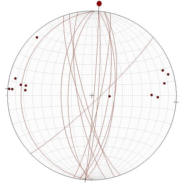
Figure 6.2: Faults stereonet. A set of normal faults and one odd strike and slip fault (Luz beach and Porto do Moz beach).
The stereonet above (figure 6.2) shows that there have been 2 phases of deformation in the mapping area. The evidence for the first phase are the North-South faults which caused East-West extension on the central Algarve. The second phase originated the Northwest-Southeast extension. Both phases of deformation occurred during the late cretaceous because they did not affect the Miocene units, and they were caused by the Pyrenean Orogeny, part of the Alpine chain formation.
The Miocene fault displacement is considerably large in comparison with the rest of the faults and is related to a different event. The gap between the Miocene fault and its closest fault has been filled by Miocene sediments, hence the name.
6.1.3 Dyke Emplacement
Fine grained basaltic dykes have intruded into the sedimentary successions across the mapping area. These dykes ranging in thickness from a few centimetres to a couple of metres, have accommodated some of the extension that resulted in the development of the faults mentioned above.
Chapter 7
7. Geological history
The first Mesozoic deposits in the Algarve basin and other zones of the Iberian Peninsula are of continental nature and include mainly conglomerates, coarse, sandstones and siltstones that have, in general, characteristic red color. These deposits are followed by dolomitic limestones and evaporites that indicate the beginning of the invasion of the basin by the sea. According to Jansa and Wade (1975), the presence of evaporites in the Algarve, Lusitanian and Aquitaine basins testifies to the westward extension of the Tethys Sea during the late Triassic.
According to Romariz et al. (1976), This distension in the basins and the subsequent rifting were related to an important igneous activity during the Jurassic and Cretaceous.
The continuation of the subsidence allowed an opening to the sea more and more accentuated. In the Sinemurian, the Algarve Basin was a vast platform where a carbonate complex was deposited, essentially consisting of dolomitic limestones and dolomites. The boundaries of this unit are probably heterogeneous (Rocha, 1976).
The transgression continues with deposition of calcareous limestones and calcareous limestones with ammonoids to the west, culminating with the pelagic formations of Callovian that appear in the nucleus of some diapiric structures to the south of the Sagres-Alportel flexure.
The lower Oxfordian, or even Upper Callovian, gap in the central Algarve (Rocha and Marques, 1979) marks a regression following the transgression of the average Oxfordian. The basement of this floor is represented by a conglomerate level containing locally fossils and phosphate nodules.
Only in the central Algarve are known basin-type deposits with cephalopods, which start in the middle Oxfordian (Rocha and Marques, 1979). The sedimentation of that type proceeds in the lower Kimmeridgian. From then on, in central Algarve, the facies changed to sedimentation of lower depth, represented by limestone with stromatoporoids, limestone, oolitic and pisolithic limestones. This series begins with a conglomerate with elements of quartz and local limestone. Miocene age formations (Ponta da Piedade) currently occupy a relatively large extent.
The marine formations begin with carbonate deposits that occupy the coastal strip that extends between Lagos and Olhos de Agua (Albufeira) constituting a platform of altitude approximately constant, covered irregularly by more modern detrital deposits. A regressive marine oscillation was responsible for the erosion and karstification of this formation, which was later covered by an essentially detrital series of continental facies (Romariz et al., 1979) with marine intercalation, as mentioned earlier.
According to Ribeiro et al. (1979), the Algarve basin includes basement terrains belonging to two different geotectonic units: Hesperian Massif and Southern Orla or Algarvia. To the north of the area, the seafloor facies settled in a flysch type of carbonic age, forming part of the South Portuguese Zone. This is also part of the Iberian branch of the Hercynian Chain, constituting the Southwest region of the Ibero-Armorican Arc of the Hercynian chain. The carbonic terrains constitute the general substratum on which more modern sediments of different ages and facies are deposited, and together they constitute the Southern Shore or the Algarve (Julivert et al., 1974 and Ribeiro et al., 1979).
Orogenic movements in the Jurassic-Cretaceous boundary are responsible for important lateral variations of facies and several sedimentary discontinuities and are also responsible for the individualization of a sedimentation domain in the Eastern Algarve with facies of greater depth and another in the Central and Western Algarve with less deep facies.
A regression of eustatic origin, was responsible for the deposition of fluvial and deltaic facies sediments, in the western side of the basin. This phase was followed by a gradual subsidence, which mainly affects the eastern Algarve, during which a thick series of marine sediments crowned by the sub-crystalline limestones of Pao Branco were deposited.
In the mapping area (central Algarve), sedimentation started during Lower cretaceous, Aptian, in a period of transgression when sea invaded the land increasing the sea depth. Shallow areas became deep and land became shallow beach area. During this period Calheta sandstone was deposited on the beach. After that, in the Aptian and Albian, Luz and Moz formation were deposited. Isostatic sea level change played an important role during the formation of these rocks, as there was not any major tectonic event during that period that could cause lead to environmental conditions. Sea level changes allowed both shallow and deep water environment rocks to be deposited, for example: deep marine Luz mudstones and shallow marine Moz limestones.
In the Upper Cretaceous, the Algarve basin underwent one of its major tectonic events which led to basin inversion in the early Paleogene. Because of this movement, no sedimentation occurred onshore in the basin during the Paleogene, thus the Aptian – Miocene unconformity (figures 5.15 and table 7.1)
Moreover, this rotation in the Algarve Basin and in all Iberian Peninsula at the end of cretaceous was due to the opening of the Gulf of Gascony and gave origin to the implantation of the sub-volcano Massifs of Sintra, Sines and Monchique. This tectonic movement also originated the installation of the volcanic chimneys and dykes that cut through Luz and Moz formations.
In the Neogene a period of subsidence and transgression occurred again in all the basins, particularly in the South of the Lusitanian basin and in the Alentejo and Algarve basins, where thick sequences of terrigenous materials and shallow marine carbonates were accumulated. In central Algarve (Lagos coastal area), the rocks deposited during the Neogene (Miocene) were Ponta da Piedade limestones which accumulated in a carbonate platform, reefal environment, which resulted from the inversion of the basin.
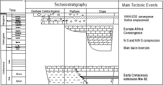
Table 7.1: Main tectonics events and main stratigraphic units of
The Algarve basin (adapted from Matias et al., 2011; Terrinha,
1998; Fernandes et al., 2013).
Ponta da Piedade limestones have undergone severe erosion and karstification. This erosion has originated gaps and orifices in the unit which were then filled by more recent Tortonian sediments (refer to figure 7.1 above). Moreover, the karstification and erosion have given origin to spectacular geomorphological features that can be seen in the Algarve coast from Ponta da Piedade to Albufeira.
There was not much deformation in the mapping area. However, on a larger scale, in the South Portuguese Zone the main phase of deformation was post-Westphalian since there is a sedimentary continuity between the Devonian and the Carbonic. On the other hand, the first well-known lands, are post-orogenic.
An important regional survey has been pointed out as responsible for the almost total absence of all the Permian and much of the Triassic. Two explanations have been advanced for this survey:
1. In the Permian, after a final major compression phase affecting the western part of Portugal, the construction of the Hercynian Chain was completed. In the collision zone the crust was elevated by isostatic readjustment (Mougenot et al., 1979).
2. From the Permian, there was an important extension, preceding the opening of the Mesogeios, which caused a warming of the lithosphere and its intumescence. At the stage of blistering a phase of distension follows during the Upper Triassic and the Liassic.
The first phase of rifting, which led to the formation of the western and southern basins, began during the Upper Triassic and Lower Jurassic (Dewey et al., 1973; Antunes et al., 1981). The first deposits were clastic, reddish sediments, coarse of the Upper Triassic to which thick evaporite deposits, mainly made up of salt and anhydrite, with some dolomites, marls and argillites, of age between the Upper Triassic and the Hetangian (Dewey et al. (1973). The evaporite sequence, which is less developed in the Oporto basin, is particularly thick in the Lusitanian and Algarve basins where, by halokinesis, it played an important role in the structuring of the basins (Romariz et al., 1979; Mougenot et al., 1976).
Regional subsidence continued and during the Lower and Middle Jurassic, deep marine carbonates were deposited in the Lusitanian and Oporto basins. Manuppelle et al. (1984) outlined that this transgression ended in the Pliensbachian-Toarcian. Moreover, long the east and west edges of the southern Lusitanian basin, from Bajocian to Callovian, shallow carbonate platforms were developed that indicate the beginning of a regression (ibid).
In the Algarve basin, continuous shallow marine conditions persisted during the Upper Jurassic and Lower Cretaceous, with no clear evidence of the second phase of rifting. The Cretaceoustransgression reaches its maximum in the Cenomanian, with sedimentation only resumed, in the North of the Lusitanian basin and in the Porto basin, in the Turonian and Senonian (Fernandes et al., 2013).
As a result of the collision between the African and Eurasian plates, the first compressions were felt in the Eocene (Pyrenean phase of the Alpine orogeny), causing crustal shortening and inversions in the basins, particularly in the north of the Lusitanian basin and in the Porto basin. In contrast, the Baetica phase of the same orogeny affected mainly the southern part of the Lusitanian basin, the Alentejo basin and the Algarve basin Arthaud. Most structuring of the sedimentary filling of the basins as a consequence of these compressive episodes was controlled by the hercynic failure pattern of the punch and amplified by the halokinese.
7.2 Summary of the Geological History of the mapping area
| Time | Event |
| Cretaceous |  Aptian: Transgression cycle caused sea to in Aptian: Transgression cycle caused sea to in
Land. Calheta formation was deposited in Moderate moving water with continental influence. Luz formation was deposited in slight deeper Lower and shallow waters with land input as well. Albian: Regression caused sea level to drop. Moz formation was deposited in a shallow environment.
Opening of the Gulf of Gascony. Upper North-South and Northwest-Southeast Compression, originated Luz and Moz faults. Igneous Intrusion (Pedra Negra and dykes). |
| Paleogene | Main Basin Inversion
No sedimentation onshore in the Algarve basin Albian – Miocene Unconformity |
| Neogene |  Early: Reef conditions, carbonate Early: Reef conditions, carbonate
platform. Ponta da Piedade formation was Miocene deposited. Tortonian: Erosion of the early Miocene sediments. |

Chapter 8
8. Conclusions
The geology and geomorphology of the Algarve basin is a result of tectonic events, sea level alterations and physical processes such as erosion. The breaking of the Pangea, the closing of the Thetys sea, and many other orogenic process events throughout the geological history are reflected in the Algarvian landscapes.
The onshore phanerozoic series in the Central Algarve spans from Lower Cretaceous to Miocene and are divided into four groups. The dominant lithologies are limestones, sandstones, mudstones, and marls. Paleogene sediments are absent onshore.
In the mapping area, the deposition of the rocks took place mostly in shallow waters, the variation of lithologies is associated with transgressions and regressions cycles, as well as basin subsidence.
The Upper Cretaceous igneous activity and deformation was associated with the Central Atlantic Rifting and breaking of Pangea which started during the Upper Jurassic. The intrusions observed in the mapping area occurred in the same timeframe as other major intrusions, such as the Monchique massif plateau, Sintra and Sines, all in the Portuguese coast.
The South Portuguese zone however, has less intense deformation and later than the internal zones of the Hercynian Chain, and in it, the metamorphism and the syn-orogenic magmatism are less accentuated.
Appendices
Appendix 1– Porto do Moz and Ponta da Piedade cross section. This shows how the Miocene fault has been filled by Miocene sediments.
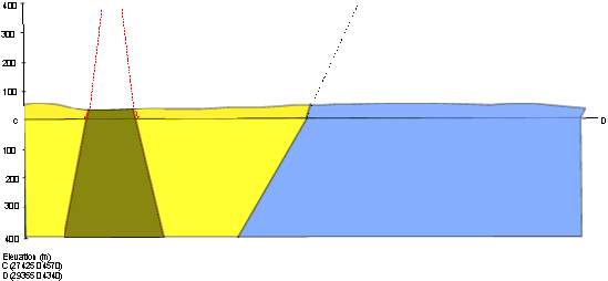
Appendix 2 – Albian (Porto do Moz) – Miocene (Ponta da Piedade) – Angular unconformity representing sedimentation time gap.

Appendix 3 – List of Main Outcrops in the mapping area.
| Outcrop | Grid Reference | Outcrop | Grid Reference | |
| Luz | Porto do Moz | |||
| 1.1 | 24535 04576 | 2.1 | 26377 04386 | |
| 2.1 | 25141 04437 | 2.2 | 26882 04324 | |
| 2.2 | 25143 04389 | 2.3 | 26972 04332 | |
| 6.1 | 25797 05688 | 2.4 | 27074 04339 | |
| 6.2 | 26080 05776 | 7.1 | 27697 05861 | |
| 6.3 | 25166 04266 | 7.2 | 27934 05240 | |
| 6.4 | 25110 04399 | 7.3 | 25292 04358 | |
| 6.5 | 25070 04400 | 7.4 | 25487 04335 | |
| 6.6 | 25003 04406 | 8.1 | 28310 04264 | |
| 6.7 | 24892 04455 | 8.2 | 28220 04291 | |
| 9.1 | 26006 06766 | 8.3 | 28153 04319 | |
| 9.2 | 26210 06664 | 8.4 | 28052 04352 | |
| Ponta da Piedade | ||||
| 3.1 | 29451 03777 | |||
| 11.1 | 29378 04993 | |||
| 11.2 | 29514 05248 | |||
| 11.3 | 28426 04285 | |||
| 11.4 | 29530 05418 | |||
| 11.5 | 29576 05515 | |||
| 15.2 | 28142 07216 | |||
References3
Albani, A.E. (2004) Paleoenvironmental Reconstruction of the Basal Cretaceous Vertebrate Bearing Beds in The Northern Part of the Aquitaine Basin (SW France): Sedimentological and Geochemical Evidence. Facies, 50(2), Pp.195–215.
Almeida, C. (1979) Inventory of Caves in The Algarve, Algarve.
Almeida, C. and Carvalho, A.M.G. (1983) Characterization of a Palaeozoic Formation “Post-Tectonics” of The Algarve, Algarve: Geological Society of Portugal.
Antunes, M.T., Bizon, G., Nascimento, A. and Pais, J. (1981) ‘New Data on The Dating of Miocene Deposits in The Algarve (Portugal), And the Regional Geological Evolution’, Earth Sciences, 6(), Pp. 153-168.
Arthaud, F. and Matt, P. (1975) ‘Late-Hercynian Droppings in Southwestern Europe. Geometry and Test of Reconstitution of The Conditions of The Deformation’, Tectonophysics, 25(), Pp. 139-170.
Berthou, P.-Y., Correia, F., Prates, S. and Taugourdeau, J. (1983) Cretaceous Synthesis Test of The Algarve: Biostratigraphy, Paleogeography, Argillous Sedimentation, Lisbon: Bull D ‘Inf. Geol. of the Paris Basin.
Bonnet, C. (1950) Algarve (Portugal). Geographic and Geological Description of this Province, Lisbon: Acad. Royale Sciences.
Callegaro, S. (2014) Enriched Mantle Source for The Central Atlantic Magmatic Province: New Supporting Evidence from Southwestern Europe. Lithos, 188, Pp.15–32.
Choffat, P. (1950) Geology of The Cenozoic Of Portugal, Lisbon: Com. Serv. Geol. Portugal.
Correia, F., Prates, S. and Berthou, P.Y. (1982) Researches on Cretaceous Biostratigraphy and Sedimentology of the Eastern Algarve (Portugal), Lisbon.
Correia, V.C.A.F. (2017) The Palynological Response to the Toarcian Oceanic Anoxic Event (Early Jurassic) At Peniche, Lusitanian Basin, Western Portugal. Marine Micropaleontology, 137, Pp.46–63.
Dewey, J.F., Pitman Iii, W.C., Ryan, W.B.F. and Bonnin, J. (1973) ‘Plate Tectonics and The Evolution of The Alpine System’, Geological Society of America, 84(), Pp. 3137-3180.
Dias, R., Araújo, A., Terrinha, P.A.G. and Kullberg, J.C. (2006) Geologia De Portugal No Contexto da Ibéria, 1 Edn., Evora: University of Evora.
Dommergues, J.-L., Meister, C. and Rocha, R.B. (2011) The Pliensbachian Ammonites of The Algarve Basin (Portugal) And Their Palaeobiogeographical Significance for the “Iberia-Newfoundland” Conjugate Margins. Swiss Journal of Geosciences, 104(1), Pp.81–96.
Fernandes, P., Borges, M. E. N., Oliveira, J. T. and Pereira, Z. (2009) CIMP Field Trip 09, Faro, Algarve: UALG – University of Algarve, LNEG – LGM (Geological Survey).
Fernandes, P., Borges, M.E.N., Clayton, G., Rodrigues, B. and Matos, V. (2013). Organic maturation of the Algarve Basin (southern Portugal) and its bearing on thermal history and hydrocarbon exploration. Marine and Petroleum Geology, 46, pp.210–233.
Fernandes, S., E. Font, E., Neres, M., Martins, L., Youbi, N., Madeira, J. and Marzoli, A. (2014) The Central Atlantic Magmatic Province (CAMP) In Portugal, Porto: LNEG.
Ferreira, O.V. (1951) Pectnídeos Do Miocénico Do Algarve, Lisbon: Geological Service of Portugal.
Fonseca, J., Marzoli, A., Madeira, J., Dalcorso, J., Preto, N. and Tateo, F. (2014) Mineralogical and Carbon Isotope Characterization of a PreCAMP Sedimentary Sequence: Evidence for An Earlier Eruptive Camp-Related Event, Evora: University of Evora.
Font, E. (2015) Palaeomagnetism of The Central Atlantic Magmatic Province in The Algarve Basin, Portugal: First Insights. Tectonophysics, 663, Pp.364–377.
García-Navarro, E., Fernandez, C. and Camacho, M. A. (2005) Mesozoic Tectonic Evolution of The Southwest Continental Iberian Margin, Huelva: University of Huelva.
Legoinha, P.A.R.R. (2001) Biostratigraphy of The Miocene Forams Of Portugal, Lisbon: New University of Lisbon.
Manuppella, G., Rocha, R.B., Marques, B. and Ramalho, M.M. (1984) Geological Mapping of The Algarve, Algarve.
Marques, F.M.S.F., Matildes, R. and Redweik, P. (2013) Sea Cliff Instability Susceptibility at Regional Scale: A Statistically Based Assessment in The Southern Algarve, Portugal, Lisbon: University of Lisbon.
Martins, L. (2008) Rift-Related Magmatism of The Central Atlantic Magmatic Province in Algarve, Southern Portugal. Lithos, 101(1-2), Pp.102–124.
Mougenot, D., Monteiro, J.H., Dupeuble, P.A. and Malod, J.A. (1979) The South-Portuguese Continental Margin: Structural and Sedimentary Evolution, Lisbon.
Moura, D., Gabriel, S. and Jacob, J. (2011) ‘Coastal Morphology Along the Central Algarve Rocky Coast: Driver Mechanisms ‘, Journal of Coastal Research, 64(0749-0208), Pp. 790-794.
Oliveira, J.T. (1983) The Marine Carboniferous Of South Portugal: A Stratigraphic and Sedimentological Approach, Lisbon: Geological Service of Portugal.
Oliveira, J.T. and Fernande, P. (2010) The Geology of Vila Do Bispo, Algarve: Vila Do Bispo Municipal Council.
Parant, B. (1963) Geological Recognition of The Algarve, Lisbon: C.P.P.
Pilkey Jr, O.H., Neal, W.J., Monteiro, J.H. and Dias, J.M.A. (1989) ‘Algarve Barrier Islands: A Non-Coastal-Plain System in Portugal ‘, Journal of Coastal Research, 5(0749-0208), Pp. 239-259.
Portugal Ferreira, M. and Macedo, C.A.R. (1977) Basaltic-Permian-Liassic Activity in The Portuguese Territory, Coimbra: University of Coimbra.
Pratsch, J.C. (1958) Stratigraphic-Tectonic Investigations in The Mesozoic Of Algarve (Southern Portugal).
Rey, J. (1983) The Cretaceous Algarve: Synthesis, Geological Service of Portugal.
Ribeiro, A. and Allia (1979) Introduction to The General Geology of Portugal, Lisbon: Geological Service of Portugal.
Riché, P. (1962) Note on The Mesozoic And Tertiary Basin of The Algarve, C.P.P.
Rocha, R.B. (1971) Contribution to The Geological Study of The Region of Cabo De S. Vicente – Alvor, Lisbon: Geological Service of Portugal.
Rocha, R.B. (1976) Stratigraphic and Paleontological Study of The Jurassic Of the Western Algarve, Lisbon: New University of Lisbon.
Rocha, R.B. and Marques, B. (1979) The Jurassic Of the Algarve (Portugal): Stratigraphic Sketch and Paleogeographic Evolution, Lisbon: Geological Service of Portugal.
Romariz, C., Almeida, C. and Silva, M.O. (1979) Contributions to The Geology of Algarve (Portugal). Ii-Volcanic Structures in Eastern Algarve (Portugal), Lisbon: Museum and Lab Min. And Geol. Of Fac. Sciences.
Romariz, C., Correia, F. and Prates, S. (1979) Contributions to The Geology of The Algarve (Portugal). Ii-A New Facies of The Miocene, Lisbon: Museum and Lab Min. And Geol. Of Fac. Sciences.
Romariz, C., Oliveira, M., Almeida, C., Baptista, R. And Cardoso, J. (1979) Contributions to The Geology of Algarve, Portugal. I-The Miocene Facies of Eyes of Water, Lisbon: Museum and Lab Min. And Geol. Of Fac. Sciences.
Romariz, C., Silva, M.O., Almeida, C. and Palma, F. (1976) Volcano-Sedimentary Episodes in The Algarve (Preliminary Note), Lisbon: Museum and Lab Min. And Geol. Of Fac. Sciences.
Terrinha, P. A. G. (1998) Structural Geology and Tectonic Evolution of The Algarve Basin, South Portugal, London: Imperial College.
Veludo, I., Dias, N.A., Fonseca, P., Matias, L., Carrilho, F., Haberland, C. and Villaseñor, A. (2017) Crustal Seismic Structure Beneath Portugal (Western Iberia) And the Role of Variscan Inheritance, Vienna: EGU.
Cite This Work
To export a reference to this article please select a referencing stye below:
Related Services
View all


Related Content
All TagsContent relating to: "Geology"
Geology is an “Earth science” or “geoscience” concerned with the study of the physical structure of the Earth (or other planetary body) and the rocks of which it is made, the processes that shaped it and its physical, chemical and biological changes over time.
Related Articles

DMCA / Removal Request
If you are the original writer of this dissertation and no longer wish to have your work published on the UKDiss.com website then please: