The Hydrology of the Nile River Basin: Literature Review and Comparison Between Two Model Structures
Info: 7501 words (30 pages) Example Literature Review
Published: 9th Dec 2019
Tagged: International Studies
THE HYDROLOGY OF THE NILE RIVER BASIN: LITERATURE REVIEW AND COMPARISON BETWEEN TWO MODEL STRUCTURES
Abstract.
This report presents a review for some of the hydrological studies that were carried out in the Nile Basin. Firstly, the studies concerned with the understanding of the hydrological process are discussed, to show the gap between the physical understanding and the modeling of the hydrological processes in the Nile basin then to discuss some of the studies carried out to bridge this gap. Secondly, two main research concerns in the Nile basin are discussed; showing the effects of watershed characteristics changes and climate changes on the hydrological processes in the Nile basin. Lastly, a comparison between two modeling approaches is introduced the results show that despite that the two models are different in structure, both give very close results.
1 Introduction
Water is the source of life on earth. Sustainable water use and management are of paramount importance to maintain a healthy life for all creatures. Hydrology is considered a very important tool that assists the implementation of proper management that benefits industry, agriculture, and the environment. The study of hydrology is a difficult task because it requires the observation and understanding of diverse and complex processes that govern the water cycle on earth. For centuries, there was big effort done to study, model and represent hydrological processes over and under the ground. Nevertheless, the hydrological phenomenon is not fully understood and still needs more and more studies to overcome the issues and the shortage of understanding.
The Nile River is one of the most important rivers in the world. The basin is home for 257 million people that are almost 20% of African population (Nile Basin Initiative, 2016), moreover, the Nile basin is characterized by one of the most important biodiverse ecosystems on earth. The studying of the river hydrology is of high importance for many aspects. First, the high vulnerability of the basin to floods and droughts which pose risk for the lives of population especially those living in flood plains. Second, there are political disputes between upstream and downstream countries over the use of water which is basically water management problem that needs to be supported by hydrological studies. Third, the system is suffering from great losses due to evaporation and seepages along the river course which needs further studies and to be prevented if possible. The system is subjected to high erosion especially in the Blue Nile basin which is a very important issue. Lastly, the basin hydrology is affected by the changes in basin characteristics due to deforestation and changing land uses, also due to climate change. All these points and more are of high concern to the hydrological research in the Nile basin.
This report aims to provide a literature review for selected studies in the Nile Basin that draw much attention in last years. The topics covered are; the hydrological modeling used in the basin studies and the effort done to improve them, the detection of hydrological changes due to the change of watershed characteristics, and the expected effects of climate change on the hydrology of the basin. In addition to literature, the final part of the report will include research work done to compare between two different model structures by using the area of Upper Blue Nile as a case study.
The following structure is followed in this report. Section (2) covers background information about the study area of the Nile River. Then, Section (3) discusses the literature for three different issues that were the main focus of the hydrological studies that carried out in the Nile basin. First, the effort made to improve the understanding of the hydrological process and to link the physical understanding to modeling is covered. Second, the last section of the literature will discuss two of the main areas that draw much attention in the Nile basin: the studies of watershed changes and their effects on the hydrological process, and the climate change studies. Section (4) discusses the modeling work done. Finally, section (5) will include the conclusions for the literature and the modeling work results.
2 Study Area
The Nile River is considered one of the longest rivers in the world with an approximate length of 6,700 km. the river’s journey begins at Lake Victoria in Burundi, Tanzania and Rwanda, then travel along its course passing through 11 riparian countries (Tanzania, Kenya, Eritrea, Ethiopia, Burundi, Rwanda, Democratic Republic of Congo, Egypt, Uganda, Sudan and South Sudan) till it reaches the river estuary at the Mediterranean Sea in Egypt. The river basin has the area of about 3 million Km2 that is distributed among the basin countries. The Nile Basin is commonly divided to three different sub-basins, Eastern Nile sub-basin, Equatorial Nile sub-basin, and Main Nile Zone.
The Eastern Nile sub-basin comprises three catchments (Blue Nile, Atbara, Baro) as Figure (1) shows, these catchments mainly lie in the highlands and the plains of Ethiopia, Sudan, and South-Sudan. This sub-basin is the major contributor to the flow that reaches Aswan (Egypt) with percent between 85% and 90%, the outflow of this sub-basin is seasonal due to the monsoonal rainfall and the major part of it comes from the Blue Nile catchment. The Equatorial Nile sub-basin is the area that cover the Equatorial Lakes region and parts of South-Sudan and ends at the confluence of White Nile and Sobat. The huge lakes and numerous wetlands in that sub-basin act to damp the outflow, and to cause a huge evapotranspiration losses in that area. Thus, the outflow of this sub-basin is only 10 to 15 percent of the annual flow that reaches Egypt but evenly distributed through the year. The Main Nile Zone is the final reach of the Nile River that starts at the confluence of White Nile and the Blue Nile at Khartoum. This zone contributes zero flow to the system, while there are considerable evaporation losses from the different reaches in that area. The downstream of that zone is controlled by High Aswan Dam (HAD), that provides irrigation water to Egypt and Sudan (Nile Basin Initiative, 2012).
Figure (1): Nile River sub-basins, Source: Nile Basin Initiative (2016).
Yellow boundaries is the Upper Blue Nile Basin (UBNB).
The Nile Basin is characterized by highly disparate rainfall distribution both spatially and seasonally. The equatorial zone is subjected to two different rainy seasons. While for the rest of the basin only one season is seen usually in the summer period. The annual rainfall is decreasing in the direction of the downstream (towards Egypt and Sudan). In which, the average annual rainfall values are ranging from more than (2000 mm/year) at Ethiopia and Uganda till it reaches values close to zero at Egypt (Nile Basin Initiative, 2012).Most of the runoff is generated from the Ethiopian plateau and Equatorial Lakes region, despite the high rainfall volume falling on the basin only 30 mm is generated as runoff if spread on the entire basin and that is attributed to the relatively small flow generating area and high conveyance losses.
The high variability in rainfall is also accompanied by high variability in Evapotranspiration. Egypt and Sudan which are arid countries have the highest potential for Evapotranspiration compared to upstream humid countries. However, water availability forces the Evapotranspiration to be more in upstream countries rather than downstream. Regarding the Evapotranspiration components, Lake Victoria sub-basin has the highest evapotranspiration losses over open water, while the Blue Nile sub-basin has the highest over land losses and the Sudd sub-basin the highest value over wetlands. The Nile Basin is highly vulnerable to droughts because of the rainfall variability and high potential evapotranspiration, the problem is magnified by the uncertainty rainfall events onsets, recurrent rainfall cessation and long period below average rainfall. (Nile Basin Initiative, 2012).
3 Literature Review
3.1 Hydrological Modeling
For many years, the Nile Basin has been the focus of an increasing number of hydrological studies for different purposes. Some studies focused on understanding the hydrologic processes ( eg. Liu et al., 2008;White et al., 2011), detecting effect on hydrological process caused by changes in watershed characteristics (eg. Gebrehiwot et al., 2013) and climate (Elshamy et al., 2009), predict erosion and sediment loadings (eg. Betrie et al., 2011). Hydrological models of different structures and types were used in these studies that were conducted on different watershed scales. Their findings, limitations and challenges to the hydrological modelling in the Nile Basin will be discussed in this section.
Most of the hydrological models used in the Nile basin are developed and tested in temperate climates in Europe and North America and may not be appropriate for tropical monsoonal climate with relatively long dry periods, as in the case for most of Nile Basin. In the Nile basin, the temperature and rainfall patterns lead to different soil moisture patterns compared to those of the temperate climate regions in a way that makes the intensity of rainfall is not significant in determining the runoff as those models assume(Awulachew et al. ,2008). Few studies suggested that even simple water-balance models can be sufficient to predict observations and better than complex models especially on bi-weekly and monthly time steps. (e.g. Awulachew et al. ,2008; Steenhuis et al., 2009; Tekleab et al. ,2011; Conway et al. ,1997).
However, one limitation of water balance models is that they simulate flow at single outlet points and don’t give much information about the spatial distribution of flow which is essential for erosion studies and other watershed management applications. So semi-distributed models like WEPP, SWAT, EPIC, etc. may be a solution to the problem. A main issue in using these models is that they don’t predict distributed flows correctly as they use SCS-CN method which depend on the land cover and soil type in flow generation and doesn’t consider the variation in topography which is a major factor in flow generation in most regions in the Nile Basin. As in many parts of the basin, flow generation is governed by saturation excess especially in flat regions, while most of the previously mentioned methods only uses infiltration excess method (Liu et al., 2008; Steenhuis et al., 2009).
In the light of the previously mentioned challenges and limitations, there were many studies that tried to improve the representation of physical process carried in the Nile Basin. White et al. (2011) showed that a modified spatially varied water balance SWAT model (SWAT-WB) performs better than the original SWAT model when applied in the Blue Nile basin. This work highlighted the importance of topography in runoff generation in this area and presented the benefits of using a distributed model. Dessie et al. (2014) showed that even by using a simple conceptual model the topographical characterization of the basin can result in a considerable improvement to hydrological process representation and flow simulation.
3.2 Hydrological Change Detection
Hydrological Cycle and River flows are affected by climate change and changes in watershed characteristics ( Kundzewicz, 2004). The Nile Basin has various problems like soil degradation, land degradation and deforestation that are known to cause changes to hydrological processes. Regions like Ethiopian Highlands and Equatorial Lakes region are among the highest areas subjected to high soil erosion and serious deforestation (Nile Basin Initiative, 2012).Climate change could impose more stresses on the already scarce water resources in the Nile Basin. For example; the increasing demand of water for densely populated Nile valley in Egypt is highly dependent on the water generated upstream, also, drylands at north of Sudan are subjected to recurrent droughts and encroaching desert towards the green areas. In the same context, there is a high risk of flooding on the high dense populated cities along the Nile River especially in the low lands of Ethiopia, Sudan, and South-Sudan (Nile Basin Initiative, 2012).
3.2.1 Watershed Characteristics Change
The changes that occur in the soil, land cover, geology, and geomorphology whether anthropogenic interventions or natural should attract great attention in terms of how they could affect different hydrological processes. These changes could alter the watershed characteristics and subsequently its hydrological regime. The detection and understanding of these changes are of great importance for proper watershed management. One important issue for the change detection studies is the availability and consistency of forcing and runoff data, many errors and misleading results could be reached due to data errors or changing of data measuring method (Seibert & McDonnell, 2010; Kundzewicz & Robson, 2004). And because of the scarcity and inconsistency of data in the Nile basin, the study of change detection was not paid much attention in the past(Melesse et al., 2009). Nevertheless, some studies were concerned with the vulnerable areas like the Blue Nile basin (eg. Gebrehiwot et al., 2013; Gebremicael et al., 2013;Rientjes et al., 2011), in addition to, very few studies in the Equatorial Lake Basin (eg.Mati et al., 2008). The presence of satellite images and global data sets could be very useful in the future to cover more areas and lead to more accurate studies. Land cover and satellite images data show a change in vegetation cover in the Nile Basin in the last decades, specifically increase of agriculture lands in replace of forests, woodlands, and grasslands, these changes in the land cover are thought to change the hydrological regime of different watersheds, accordingly flow volumes and patterns could have been altered (Gebrehiwot et al., 2013; Gebremicael et al., 2013; Rientjes et al., 2011; Mati et al., 2008).
The study of change detection can be carried out for different watershed scales. Also, different methodologies are used. Some use the statistical methods or the hydrological models solely, but other studies use a combination of them (Gebrehiwot et al., 2013). For the case of the Nile Basin, the Blue Nile was extensively studied. Studies cover many small scale catchments in the head waters of the Blue Nile (UBNB), for exapmple, Gebrehiwot et al. (2013) applied a model-based approach (HBV) on four small scale catchments (Birr, Upper-Didesa, Gilgel Abbay, and Koga) and deduced that there was no significant change in the flows of the four catchments in the period of (1960-2001).Also, Rientjes et al. (2011) estimated the changes of a small catchment (Upper Gilgel Abbay catchment). This study shows a minor decreasing trend for the flows over the period from (1973-2005), also a change in the pattern of flows in the same period due to the changes in land cover in the basin. And, Woldesenbet et al. (2017) detected the changes in two small watersheds (Tana and Beles). The relation between specific landuse class and the change in specific hydrologic component (ex. Base flow, runoff, etc….) was estimated for the first time in the Nile basin using a combination of statistical method (Partial least squares regression) and hydrologic model (SWAT). The Tana basin overall flow showed a decreasing trend due to landuse change in the period between (1973-2010). Conrarly, the Beles basin overall flow increased in the period between (1986-2010).
In addation to small scale studies, The Blue Nile was studied also on large scale.Gebremicael et al. (2013) used a combination of statistical tests, SWAT model and concluded that there was significant increase in flows of the Upper Blue Nile basin due to Land use change in period of (1970-2009). Out side the Blue Nile, Mati et al. (2008) used a model-based method (Geospatial Streamflow Model) on Mara river catchment which is one of the small catchments of Victoria Lake Basin. Mati find an increase in Mara river flow and also earlier peaks due to the change in Land use in the period of (1970-2000).
Some of the challenges for the process of hydrological change detection, are found to be in the fact that the results are highly dependent on many factors like; watershed characteristics, scale, the approach used, and climatic forcing. For the same watershed (or neighboring ones), a completely different conclusion can be reached based on these factors. Other challenge is the interaction of the effect of climate change and land use change on altering of watershed hydrology, this interaction is not fully understood and needs more research (Melesse et al., 2009).
Many studies showed The importance of using physically based models in change detection and to know which parameter is linked to which watershed characteristic (Gebrehiwot et al., 2013; Rientjes et al., 2011). Nevertheles,One important issue for the methods that rely on modeling is that they usually reflect high uncertainty in the results that are related to the uncertainty in the forcings, observations, model, and parameters. This uncertainty should be addressed and well defined in any watershed change detection study (Seibert & McDonnell, 2010). Another issue for modeling, is that detecting the change by observing model parameters change can be misleading due to parameter compensation during the model simulations that could alter the results (Gebrehiwot et al., 2013).
3.2.2 Climate Change
Globally, it was noticed the recurrent intense and frequent disasters and damages that were recorded due to hydro-climatic extremes, these incidents attracted much attention to study the possible impacts of climate changes on the hydrological regime (Taye et al., 2015). In the Nile Basin, in addition to disasters, there is one important issue. Water uses is already under stress and is expected to increase in the future due to population increase. Therefore, any future changes to flow amounts could magnify this stress and threaten the life of people living in the basin (Siam & Eltahir, 2017). Thus, the study of climate change impacts is of great importance globally and for the Nile Basin as well. The studies of climate change for the Nile River were concerned about two main issues: first, discovering and proving if there is any change in climate and hydrology in the historical records, and the second, how will the future looks like? The following paragraphs will discuss these two issues in detail.
In terms of historical trends, there are different statistical methods that are used to detect the existence of trends and non-stationarity in historical time series of rainfall and streamflow, and many of these methods were applied in the Nile Basin. Most of the Nile studies show that extreme conditions are rare. Also, most of these studies used statistical methods to study the characteristics of extreme events, yet the way these extremes are defined is usually study-specific (Taye et al., 2015). Regarding precipitation trends, Conway (2000) noted that there is no significant trend for the annual precipitation in the Upper Blue Nile basin (UBNB) between the period of 1900- 1998 except for the high rainfall decrease in the 1960’s and 1980’s. Other studies agreed that there is no significant trend, for example, (Mengistu et al., 2014) for rainfall between 1980-2010 and (Gebremicael et al., 2013) between 1970-2005. Moreover, Seleshi & Camberlin (2006) posit that no trends are found for the extreme rainfall events over Upper Blue Nile Region for the period of 1965-2002. Historical Stream flow was also investigated for trends in many studies at different scales, Gebremicael et al. (2013) reported significantly increasing trend for the annual stream flows of UBNB and increasing trend also for the main and secondary wet seasons, contrary a decreasing trend in the dry season. Melesse et al. (2009) shows a slight decrease in low flows while no significance change to high flows in Blue Nile. Overall, there were no noticeable significant trends for both rainfall and flow over the last decades in the Blue Nile Basin, while there were more local significant trends at small scale watersheds. Also, results can be affected by not accounting the multi-decadal oscillations, regardless of that, the low flows seem to be affected by combined climate change and watershed characteristic changes, which reflects the importance of combining both issues in change detection process (Taye et al.,2015).
To study the future projections of climate change on hydrological extremes, General Circulation Models (GCM) are often being used, these models are of coarse resolution and usually need downscaling method and/or bias correction to make them fit small scale watersheds (Taye et al.,2015). In contrast to temprature, there is lack of agreement about the future pricipitaion trends and quantity changes (Beyene et al. , 2009). Elshamy et al. (2009) reported that there is no significant change in the annual rainfall and increase in temprature between (2 oC – 5 oC) for the Upper Blue Nile Basin, using the ensamble mean of 17 GCMs for the period of 2081-2098. While, Beyene et al. (2009) stated that the average of 11 GCMs showed increase in rainfall in (2010-2039) and decrease in mid- (2040-2069) and late ( 2070-2099) for the whole Nile Basin (NB), aslo showed increase in temprature of (0.91 oC -1.95 oC) for (2010-2039) and (3 oC -5.9 oC) for (2070-2099) avereged for the whole Nile Basin. For the stream flow, Beyene et al. (2009) indicated that changes in precipitaion and temprature will affect disproportionaly the stream flow, flows increased by 26% for (2010-2039) , and declined by 10 % in (2070-2099) for the whole NB. Elshamy et al. (2009) stated that a stream flow reduction is expected in the future for the UBNB regarding the raised temprature and hence Evapotranspiration with almost no change in precipitation. Regarding the future impacts on extreme flows, few studies investigated the projection on extreme flows on both large and small scales (Taye et al.,2015). Results also showed high variability. Nawaz et al. (2010) used three GSMs to study the impacts of climate change on hydrological extrems at the UBNB, the results for the high daily flow exceded 5% of the time (Q5) varied from -47% to +32% for the three GCMs.Enyew et al. ( 2014) studied the impacts of three different GCMs on droughts in Lake Tana Catchment in the BNB, the results highly varied for droughts magnitude and trends for each GCM. Aich et al. (2014) studied the impact of five GCMs on the UBNB extreme flows, the results showed increase between 10% to 50 % for daily flow exceded 10% of the time (Q10), while low flows (Q90) increased between 40% to 60%, also other odd values were reported for both Q10 and Q90.
The studies of future climate change mentioned here, seem to agree on the trend of temperature in the future but there was a large variability in the results of rainfall and stream flows, this variation could be attributed to the various sources of uncertainty in the GCMs used and the whole modeling process. The studies of climate change impacts on hydrology are always accompanied by significant uncertainty, Di Baldassarre et al.,(2011)reviewed different studies for the Nile Basin and indicated the importance of combining the climate studies with appropriate definition to uncertainty to help in the process of decision making. The uncertainty in the downscaling and bias correction approaches is also important which was not drawn much attention in the Blue Nile basin (Taye et al.,2015). Two more issues that increased uncertainty are the lack of observational evidence to support the future claims and the absence of consistent physical approach. All these reasons encouraged Siam & Eltahir (2017) to use two different consistent approaches (which are, GCMs simulated flow; and based on projected changes in El Niño and La Niña events) to detect future changes in the Upper Blue Nile River and Atbara River basins. The results showed high agreement between recent observation trends and future scenarios for the previously mentioned approaches. Based on these results a conclusion was made that the long-term flow mean will increase by 15% in the twenty-first century compared to the twentieth century but also with an increase in interannual flow variability in the same period. Moreover, the sensitivity of conclusion to different GCMs combinations was tested and the conclusions remained the same. The results and conclusion of this paper could be of high importance for the management and future planning purposes in the Nile Basin.
4 Model Comparison
4.1 Introduction
Hydrological models are classified based on how they are representing the real world system in to two categories; physically based models, and empirical models. Conceptual models are in-between them (includes both empirical and theoretical equations). There is a debate in the scientific community regarding which hydrological model is better to use. Some argue that physically based model reflect better the nature of different processes. Others see that physical models are computationally expensive, and still don’t reflect the heterogeneity of catchment properties and still hold more uncertainty as more parameters are usually required, also they are not applicable to every catchment. Some see conceptual models are more reliable due to less computation time, high efficiency to simulate flows, and wide applicability. In the light of the previously mentioned debate, two different models reflecting different degrees of complexity and structures, SWAT as a complex model, And HBVas a simple conceptual model were applied to a study area and being compared and evaluated based on how well their results close to the observed flows. Evaluation criteria are; Calibration – Validation (daily time step). Capturing of variability or seasonality.Performance on different temporal scale.
4.2 Model Description
The two models have almost the same general structure. HBV is based on the famous bucket model and SWAT can be simply considered a series group of linear reservoirs. But the underlying and governing equations are different between the two models. SWAT accounts for spatial variability in watershed characteristics and consequently model parameters, while HBV not. Flow components (interflow, Base flow, direct runoff) are calculated by different methods in SWAT than HBV. SWAT allows for more losses in the system than HBV. SWAT is apparently more complex and hence computationally intensive compared to the simple model of HBV.
4.3 Study Area
Upper Blue Nile Basin (UBNB) (Figure (1)), is an important part of the Blue Nile Basin and the whole Nile Basin as well. The Basin contributes by 40-50 billion cubic meters to flows that reach Egypt at downstream (around 50-60 % of the total flow of the Nile River) which reflects the significance of the basin to Egypt, Sudan, and Ethiopia. Numerous studies were conducted on the basin using HBV and SWAT. The basin lies in a relatively high harsh mountainous area and receives rainfall in a single season with a total of 1650 mm/year and no considerable snow. The basin area is 170 thousand Km2 with a runoff ratio of only 0.17 which reflects high losses in the system due to Evapotranspiration, interceptions, and Groundwater recharge.
4.4 Results and Analysis
4.4.1 Sensitivity Analysis
For HBV, sensitivity was shared by 4 parameters (FC, FRAC, K2, and LP). Reflecting high significance to soil storage. Which is the case for most hydrological models. Especially here were Runoff ratio is just 0.17 so the soil plays an important role to accommodate the high deficit between rainfall and runoff. Regarding that, there are no losses allowed except through evaporation, which makes LP( threshold for reduction of Evaporation) high. The parameters of the slow reservoir are more important and sensitive compared with the fast reservoir, which reflects the significance of base flows, and this agrees with observations and other studies. That means that HBV represents the physical meaning well.SWAT agrees with HBV that soil and base flow are the most significant parts of the model structure. Soil and groundwater parameters are taking more than 71% of the model sensitivity.
4.4.2 Calibration-Validation
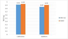
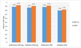
For single objective calibration, DDS(Dynamically Dimensioned Search Algorithm) was used based on NSE(Nash–Sutcliffe Model Efficiency) and NSE-log results came as Figure (3) shows. Both showed very good values although SWAT results are better in calibration and validation, results indicate that HBV can give good acceptable results as a complex model like SWAT in shorter simulation time. The use of multi-objective optimization method PA-DDS (Pareto Archived Dynamically Dimensioned Search) assured that SWAT gives better results as figure (4) shows, but also HBV can give comparable results as Figure (5) shows for calibration and validation. An important notice is that SWAT reached high values with only one-third (1/3) the number of runs of HBV, in which 3000 were sufficient for SWAT to reach stable Pareto-front and with higher values compared with HBV.
4.4.3 Capturing Variability
Both models showed good performance in calibration and validation using the full daily time series. To investigate more the differences between the two models, the low flows and high flows were separated based on 25% of the year high values are considered high flows (Q 25%) and the remaining are low flows (Q 75%). NSE values show very close values for HBV and SWAT as Figure (6) shows, in low flows HBV is slightly better while in High flows SWAT is slightly better but no significant difference.
4.4.4 Performance on Various Temporal Scale
In order to test the model performance for different time scales. The NSE was calculated for both models for different time scales. After calibration on daily-basis then aggregating on higher levels. Both models show high and close value, although SWAT is slightly better (Figure (7)). On annual scale, both models show low NSE values, because of the accumulation of daily scale errors but maybe if calibrated on the annual scale the results become better.
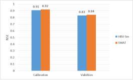
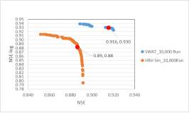
Figure (4): Pareto-Front for SWAT and HBV-sm.
(a)
(b)
Figure (3): DDS calibration and validation results Figure (5): PA-DDS Results for Calibration and
based on (a) NSE & (b) NSE-log. Validation of SWAT and HBV.
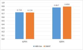
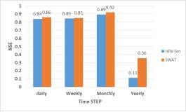
Figure (6): NSE values of low and high flows Figure (7): SWAT and HBV Comparison based on
for SWAT and HBV. different time Scales.
5 Summary and Conclusions
This paper discussed a literature review to some of the published research carried out on the Nile basin.The main challenges to the hydrological modeling in the basin are the misrepresentation of the topographical and climatic condition of the Nile basin. The ideal solution to that problem is to hydrologically model the area using fully distributed physical models but this will be data intensive and the Nile is scarce for data. So there are many studies that were carried out to solve this problem by introducing new approaches that try to better model the physics of the basin that mainly depend on topographical variation runoff generation mechanisms. The results of these studies showed improved results to the flows simulation process.
Then two main concerns in the Nile basin were discussed in detail. The first concern is the hydrological alteration caused by changing watershed characteristics. Many studies were carried out to address this issue and most of them were in the Blue Nile basin carried on small scale catchments and few on large scales, also very few studies in the Equatorial Lakes basin.the results of these studies showed contradicting results about the effect of land use changes and its effects on hydrology. This discrepancy in results can be expected due to many reasons; the high dependency of results on the used data and approaches also the interaction between land use changes and climate change. Also, the high uncertainty in results and parameter compensating issue. Second Concern is the effect of climate change on hydrological processes in the Nile, there was consensus for the temperature increase in the future but with different magnitudes between studies, while for rainfall the were contradicting results for trends and magnitudes. Siam & Eltahir (2017) attempted to decrease this discrepancy by decreasing the uncertainty of the rainfall by using a consistent methodology and accompanying the results with evidence from recent observations, they concluded the increase of long-term mean flows of the Blue Nile river.
Finally, two models were applied to Upper Blue Nile Basin to compare their results with observation and then show the differences between two model structures; complex model (SWAT) and simple conceptual model (HBV). Both models agree in the understanding of flow generation and the significant role of soil and base flow in the flow generation process for this study area which agrees with the literature as well. HBV as a conceptual model showed very close results compared to the more complex model SWAT for calibration-validation, and on different temporal scales, and on capturing the variability. SWAT calibration and validation showed better results and took less time when calibrated by multi-objective function. SWAT needs more effort to be calibrated and validated using a single objective function. SWAT and HBV daily flows are not supposed to be aggregated to annual flows except if calibrated using annual values. For practicality, HBV could be used for practical purposes like design and management, because of its good results and small computation effort.
SWAT can be calibrated by single objective calibration in a shorter time if another method is used than DDS. When calibrated with Sufi (Sequential uncertainty fitting) good results were reached in calibration and validation even with less number of runs compared with HBV. Maybe it is one of the deficits in DDS or just higher number of runs are needed.
REFERENCES
Aich, V., Liersch, S., Vetter, T., Huang, S., Tecklenburg, J., Hoffmann, P., … Hattermann, F. F. (2014). Comparing impacts of climate change on streamflow in four large African river basins. Hydrology and Earth System Sciences, 18(4), 1305–1321. https://doi.org/10.5194/hess-18-1305-2014
Awulachew, S. B., McCartney, M., Steenhuis, T. S., & Ahmed, A. A. (2008). A review of hydrology, sediment and water resource use in the Blue Nile Basin (IWMI Working Paper 131) (Vol. 131).
Betrie, G. D., Mohamed, Y. A., Van Griensven, A., & Srinivasan, R. (2011). Sediment management modelling in the Blue Nile Basin using SWAT model. Hydrology and Earth System Sciences, 15(3), 807–818. https://doi.org/10.5194/hess-15-807-2011
Beyene, T., Lettenmaier, D. P., & Kabat, P. (2009). Hydrologic impacts of climate change on the Nile River Basin: Implications of the 2007 IPCC scenarios. Climatic Change, 100(3), 433–461. https://doi.org/10.1007/s10584-009-9693-0
Conway, D. (1997). A water balance model of the Upper Blue Nile in Ethiopia. Hydrological Sciences Journal-Journal Des Sciences Hydrologiques, 42(2), 265–286. https://doi.org/10.1080/02626669709492024
Conway, D. (2000). The Climate and Hydrology of the Upper Blue Nile River. The Geographical Journal, 166(1), 49–62.
Dessie, M., Verhoest, N. E. C., Pauwels, V. R. N., Admasu, T., Poesen, J., Adgo, E., … Nyssen, J. (2014). Analyzing runoff processes through conceptual hydrological modeling in the Upper Blue Nile Basin, Ethiopia. Hydrology and Earth System Sciences, 18(12), 5149–5167. https://doi.org/10.5194/hess-18-5149-2014
Di Baldassarre, G., Elshamy, M., van Griensven, A., Soliman, E., Kigobe, M., Ndomba, P., … Uhlenbrook, S. (2011). Future hydrology and climate in the River Nile basin: a review. Hydrological Sciences Journal, 56(2), 199–211. https://doi.org/10.1080/02626667.2011.557378
Elshamy, M. E., Seierstad, I. a., & Sorteberg, A. (2009). Impacts of climate change on Blue Nile flows using bias-corrected GCM scenarios. Hydrology and Earth System Sciences, 13, 551–565. https://doi.org/10.5194/hessd-5-1407-2008
Enyew, B., Van Lanen, H., & Van Loon,AF. (2014). Assessment of the Impact of Climate Change on Hydrological Drought in Lake Tana Catchment, Blue Nile Basin, Ethiopia. Journal of Geology & Geosciences, 3(6), 1–17. https://doi.org/10.4172/2329-6755.1000174
Gebrehiwot, S. G., Seibert, J., Gärdenäs, A. I., Mellander, P.-E., & Bishop, K. (2013). Hydrological change detection using modeling: Half a century of runoff from four rivers in the Blue Nile Basin. Water Resources Research, 49, n/a–n/a. https://doi.org/10.1002/wrcr.20319
Gebremicael, T. G., Mohamed, Y. A., Betrie, G. D., van der Zaag, P., & Teferi, E. (2013). Trend analysis of runoff and sediment fluxes in the Upper Blue Nile basin: A combined analysis of statistical tests, physically-based models and landuse maps. Journal of Hydrology, 482, 57–68. https://doi.org/10.1016/j.jhydrol.2012.12.023
Kundzewicz, Z. W. (2004). Editorial – Searching for change in hydrological data. Hydrological Sciences Journal, 49(1), 3–6. https://doi.org/10.1623/hysj.49.1.3.53995
Kundzewicz, Z. W., & Robson, a J. (2004). Change detection in hydrological records – a review of the methodology. Hydrological Sciences Journal-Journal Des Sciences Hydrologiques, 49(1), 7–19. https://doi.org/10.1623/hysj.49.1.7.53993
Liu, Ben M. , Collick, Amy S. , Zeleke, Gete , Adgo, Enyew , Easton, Zachary M. , Steenhuis, T. S. (2008). Rainfall-discharge relationships for a monsoonal climate in the Ethiopian highlands. Hydrological Processes, 22, 1059–1067. https://doi.org/10.1002/hyp.7022
Mati, B. M., Mutie, S., Gadain, H., Home, P., & Mtalo, F. (2008). Impacts of land-use/cover changes on the hydrology of the transboundary Mara River, Kenya/Tanzania. Lakes and Reservoirs: Research and Management, 13(2), 169–177. https://doi.org/10.1111/j.1440-1770.2008.00367.x
Melesse, A. M., Loukas, A. G., Senay, G., & Yitayew, M. (2009). Climate change , land-cover dynamics and ecohydrology of the Nile River Basin. Hydrological Processes, 23(July), 3651–3652. https://doi.org/10.1002/hyp.7522
Mengistu, D., Bewket, W., & Lal, R. (2014). Recent spatiotemporal temperature and rainfall variability and trends over the Upper Blue Nile River Basin, Ethiopia. International Journal of Climatology, 34(7), 2278–2292. https://doi.org/10.1002/joc.3837
Nawaz, R., Bellerby, T., Sayed, M., & Elshamy, M. (2010). Blue Nile Runoff Sensitivity to Climate Change. Open Hydrology Journal, 4(0), 137–151.
Nile Basin Initiative. (2012). State of the River Nile Basin. Addis Ababa. Retrieved from http://nileis.nilebasin.org/content/state-river-nile-basin-report
Nile Basin Initiative. (2016). NILE BASIN WATER RESOURCES ATLAS. Entebbe, Uganda. Retrieved from http://nileis.nilebasin.org/content/nile-basin-water-resources-atlas
Rientjes, T. H. M., Haile, A. T., Kebede, E., Mannaerts, C. M. M., Habib, E., & Steenhuis, T. S. (2011). Changes in land cover, rainfall and stream flow in Upper Gilgel Abbay catchment, Blue Nile basin – Ethiopia. Hydrology and Earth System Sciences, 15(6), 1979–1989. https://doi.org/10.5194/hess-15-1979-2011
Seibert, J., & McDonnell, J. J. (2010). Land-cover impacts on streamflow: a change-detection modelling approach that incorporates parameter uncertainty. Hydrological Sciences Journal, 55(3), 316–332. https://doi.org/10.1080/02626661003683264
Seleshi, Y., & Camberlin, P. (2006). Recent changes in dry spell and extreme rainfall events in Ethiopia. Theoretical and Applied Climatology, 83(1–4), 181–191. https://doi.org/10.1007/s00704-005-0134-3
Siam, M. S., & Eltahir, E. A. B. (2017). Climate change enhances interannual variability of the Nile river flow. NATURE CLIMATE CHANGE, 7(April), 350–354. https://doi.org/10.1038/NCLIMATE3273
Steenhuis, T. S., Collick, A. S., Easton, Z. M., Leggesse, E. S., Bayabil, H. K., White, E. D., Awulachew, S. B., Adgo, E. & Ahmed, A. A. (2009). Predicting discharge and sediment for the Abay (Blue Nile) with a simple model. Hydrological Processes, 23, 3728–3737. https://doi.org/10.1002/hyp.7513
Taye, M. T., Willems, P., & Block, P. (2015). Implications of climate change on hydrological extremes in the Blue Nile basin: A review. Journal of Hydrology: Regional Studies, 4, 280–293. https://doi.org/10.1016/j.ejrh.2015.07.001
Tekleab, S., Uhlenbrook, S., Mohamed, Y., Savenije, H. H. G., Temesgen, M., & Wenninger, J. (2011). Water balance modeling of Upper Blue Nile catchments using a top-down approach. Hydrology and Earth System Sciences, 15(7), 2179–2193. https://doi.org/10.5194/hess-15-2179-2011
White, E. D., Easton, Z. M., Fuka, D. R., Collick, A. S., Adgo, E., McCartney, M., … Steenhuis, T. S. (2011). Development and application of a physically based landscape water balance in the SWAT model. Hydrological Processes, 25(6), 915–925. https://doi.org/10.1002/hyp.7876
Woldesenbet, T., Elagib, N., Ribbe, L., & Heinrich, J. (2017). Hydrological responses to land use / cover changes in the source region of the Upper Blue Nile Basin , Ethiopia. Science of the Total Environment, 575, 724–741. https://doi.org/10.1016/j.scitotenv.2016.09.124
Cite This Work
To export a reference to this article please select a referencing stye below:
Related Services
View all


Related Content
All TagsContent relating to: "International Studies"
International Studies relates to the studying of economics, politics, culture, and other aspects of life on an international scale. International Studies allows you to develop an understanding of international relations and gives you an insight into global issues.
Related Articles

DMCA / Removal Request
If you are the original writer of this literature review and no longer wish to have your work published on the UKDiss.com website then please: