Effect of Cockle Bay Development on Ecological System and Social Economy
Info: 9554 words (38 pages) Dissertation
Published: 9th Dec 2019
Tagged: Social StudiesMarine Studies
Construction or Destruction?
Background information
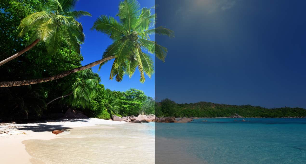
Cockle Bay is one of the bays in Magnetic Island. It lies on the western side of Nobby Head, a headland which juts out at the southernmost end of the island. The bay is populated with many small residential premises. Access to the bay is gained via an unsealed road which leads through the mangrove flats to the north of Cockle Bay. The wreck of the SS City of Adelaide is also located in the bay and become an artificial island hosting a variety of plant and bird life.
The development is proposed that a new access channel to Great Barrier Reef and comprehensive functions of marina will be built. Resort with accommodation and residential units will be added. The huge renovation in Cockle Bay hoped to bring positive impacts on social and economic fields. The success of this proposal can already be seen but before that, series of work like dewatering and dredging are to be done.
The development should not proceed due to the significant negative impacts to the seagrass and mangrove ecosystem within the bay, which outweigh the very positive effects. In this proposal, I am going to explore both positive and negative sides of the development of the Cockle Bay and how this will affect the impact of ecological system and social economy.
Ecological impacts
There are significant negative effects that the proposal will have on the living and non- living characteristics of Cockle Bay.
Seagrass biology
Seagrasses are flowering plants (angiosperms) belonging to four families, all in the Order Alismatales, which grow in marine, fully saline environments. There are approximately 58 known species of seagrass in the world, about 30 in Australia land and 15 in Queensland. In my field trip to Cockle bay, three species of seagrass are observed, in which Cymodocea serrulata is the most dominant species noticed in the shore of Cockle Bay. The average height of seagrass in Cockle Bay is around 11 cm, dark green colour and also plays an important role in the ecological systems for sheltering and feeding nutrients to sea animals. Seagrasses are adapted to their marine habitat. Different species have different salinity tolerance. While the roots of seagrasses serve to anchor the plants, they are not necessary for water intake. They share the task of nutrient collection with the leaves which can absorb food and water directly from the surrounding water. Abiotic factors for seagrass are nutrients, substrate type and sunlight. Photosynthesis can be performed with the leaves and they require clear water to obtain sufficient light. Nutrients are mainly water temperature, amount of carbon dioxide and oxygen. The nutrients are important for seagrass to survive and grow.
Seagrass plants perform a lot of ecosystem services to the marine environment. They act as habitats for small marine animals and also a place for them to hide from their consumers. When a seagrass is dead and decomposes, those animals will also be fed with it as food. Apart from these, seagrasses can refresh the water by filtering up the sediments of sand or human rubbish, which can reduce the chances of animals getting poisoned or toxic.
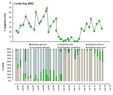
The compositions of seagrass change years after year. The trend of dominance can be varied in different season. These are all due to the climate change and habits of marine animals live nearby. In Graph 1, it shows the trend of percentage cover in different years for seagrass in Cockle Bay. It has a pattern between two species of seagrasses take turn to the prominent one. From 2005 to 2009, CS (Cymodocea serrulata) has the most percentage cover while HO (Halophila Ovalis) the least. From 2010 to 2014, they swap back.
During a recent survey for three 50m transect in Cockle bay in 2017, The dominant seagrass is back to CS, which it has 100% of the composition in two of them. HO only has a little bit of covering. No other seagrass species are observed.
Mangrove biology
Mangroves are a group of trees and shrubs with 80 species that live in the coastal intertidal zone. They are usually located in the tropical and subtropical places. In my field trip to Cockle bay, I have observed 3 zones of mangroves. After observation, zone 3 is found out that the most number of mature red mangroves, and also with other yellow, club and grey mangroves. The mature red mangroves have an average height of 4.5 m and other are shorter with an average height of 3 m. Mangroves in Cockle Bay play an essential role to shelter animals like birds, burrowing crabs, hermit crabs and snails viewed at Cockle Bay and also balance the ecological system and benefits the ecology a lot. In Queensland, there are 39 species of mangroves, and only 5 main types can be observed in Cockle Bay, Red (Phizophora stylosa), Grey (Avicennia marina), Club (Aegialitis annulata), Yellow Mangrove (Ceriops species) and Mangrove apples (Sonneratia species). Leaves, roots and flowers are parts of mangroves and are to make it grow. The special of mangroves are physically adapt their mangrove parts to able to live in extreme conditions. With the leaf adaptations, they can tolerate to survive in high salt mud or environment, and with the root adaptation, they provide a strong structural and can survive no oxygen soil or even wet mud. Moreover, they can produce offspring (seed) in different tides of environment. Some of the mangrove forests uses their own special structure, pneumatophores. They grow up laterally from the roots so that the plant can obtain the oxygen above the ground of sand.
Salinity is one of the abiotic factors, even though mangroves can survive in really bad environment, but it can’t last long. The amount of salt does harm to the mangrove plant. Sunlight is also one of them. Leaves are part of the mangrove and have the function of photosynthesis to obtain nutrients. Weather is the most important one which it includes temperature and extreme weather like heavy rain. Temperature should be always fit into the need of mangrove plants and flooding can happen which excess water might make the plants die. Biotic factors are those aquatic animals and insects and aquatic animals like molluscs which can be found in Cockle Bay. Those little animals and mangrove plants rely on each other and keep themselves surviving.
Within the species provided by the log book, grey (Avicennia marina), black (Avicennia germinans) and red mangroves (Rhizophora stylosa) are observed for a couple of times. They are all located and grow on mud areas. Hermit crabs and snails can also be spotted at the nearby river flow of the mangrove forests.
The mangrove forests act as one of the most reproductive ecosystems in nature. Mangrove plants are the habitat for a lot of little animals. Also, it gives protection to the coastal plants like coral reefs and seagrass meadow. Mangrove traps sediments flowing around the wetland and block the huge waves from the sea hitting to those inner living things.
Rocky Shore
A rocky shore is an intertidal area of seacoasts where solid rock is dominant in the whole environment. It can be found in the boundary of land and sea. In Cockle Bay, the shore is restricted to the headland and consist of large granite boulder. Rock shores can adapt to extreme environment due to the place they locate in. Tides can be varied any times and they must face the waves years over years so the structures of the rock are rigid. In my field trip to Cockle bay, the rocky shore has a horizontal rocky zonation pattern, there are oysters, shells on it. The rocky shore acts as an ecosystem to offer habitats for a lot of living animals like the oysters, burrowing crabs, snails, sea cucumbers viewed at Cockle Bay. The abiotic factors are sizes of rocks, tidal pattern and nutrients (oxygen and other elements) from the sea. Size of the themselves decide the nutrients they need and organisms live on them. And the tidal pattern decides the amount of nutrient they receive from the air and the sea.
In Cockle Bay, different kinds of organisms can be found on the rocky shores. Only one species of chiton, five limpets, three molluscs and two oysters as non-mobile creatures can possibly be found on the Rocky Shore based on the field log book. During a recent survey, oysters (Saccostrea echinate), molluscs (Monodonta labio) and limpet (siphonaria atra) are observed on a chosen big rock in Cockle Bay.
The organisms at the rocky shores can live under extreme environment and are due to the same reason as the rock which are in the same area. Different bivalves in supratidal and intertidal zones have their own adaptations to live their own ways. For those organisms that live on a high position, they are able to adapt a desert-like places which are very dry because they consistently expose to the air. For those other organisms that live on a lower position, they are able to live in a marine environment because they are consistently living under the water.
Impact of Proposal
- Dewatering of a particular area
The dewatering methods can be vacuum assisted such as ejector wells, or vacuum sealed deep wells. When groundwater is pumped from the sea with any dewatering scheme, the water level for the site will be lower. This will bring both positive and negative effects on the food web for the organisms on Rocky Shore. The hydraulic gradient will lead the polluted sea water move towards the dewatering area and the contaminated water will start to spread through the whole water. After all, the marine animals near rocky shores, including those tiny crabs or fishes will inhale those toxic materials and lead to numerous of physical diseases. After that, the food web will be affected by being unbalanced. When the food consumer does not exist anymore, the barnacles and molluscs will keep reproducing and lead to number of species getting out of control in Magnetic Island waters. In a nutshell, construction of harbour with the process of dewatering will alter the hydrodynamics of the water body and as well as the species distribution patterns in Cockle Bay.
Ground settlement is also one of the consequences when the ground level is lower. The soil will loosen up and erosion can occur in any places. In addition, the composition of soil will also decompose and collapse. This will result in lesser spaces for rocks to fill up the shores. Nevertheless, there will be a greater chance for substrate available for colonisation when the rock walls are constructed, and this will bring a positive effect on the abundance of rocky shore.
- Dredging access channel
Dredging is required to remove the unwanted deposits from waterways. Dredging is needed on an ongoing basis to maintain the access channel to the Great Barrier Marine Park and to maintain the water depth within the basin. The disadvantages of dredging are that it has a huge effect on marine biodiversity. The top layers of soil are removed and alter the original composition of the basin. There are marine animals live on the soil and their habitats will run over during the work.
A lot of sediment is resuspended in the water column as a result of dredging activity. The reduction in water clarity means that less light is transmitted to photosynthetic organisms like seagrass and corals. Without sufficient light levels these organisms can fail to grow and their survival may also be reduced. A lot of toxic materials might also be liberated from the sediment and pollute the sea. The channel will be built in the seagrass area, so the living animals there will be affected. When the seagrasses and the water body are polluted animals will be forced to migrate. There will only be contaminated seagrasses left in the area. All of these consequences will eventually lead to the unbalancing food chain and ecosystem will be greatly affected.
- Excavation work
- Harbour basin
Excavation of the harbour basin will remove any remaining seagrass and mangroves that haven’t been killed by dewatering. The chemical composition of the sediments that will form the new basin will be different and may have negative implications for wildlife attempting to survive within the marina. Excavation will make sediments more vulnerable to erosion and adjacent mangrove trees may be covered in dust which may affect growth. Reshaping of the landscape may change the hydrodynamics of the area such that access to tidal inundation may be restricted or cut-off to some of the remaining mangroves near the construction zone. Excavation will eventually lead to series of negative impacts by altering the food web and migration of animals.
- Residential units and road access
Before the work of excavation, the particular area will need to be cleared up. As a result, the mangrove forests will then need to be uprooted. As mentioned in the biology part, mangrove serves as an important ecosystem in the nature, without it, the food web will get altered. When the plant is removed, the animals relying on it will lose their habitats and force to migrate. As a barrier for costal protection, the other big ecosystem like seagrasses will also get affected.
In 1970s, the East Trinity site in Cairns is aimed to build up an environmental reserve for the plants. However, the soils were usually waterlogged were exposed to the air, which liberate sulfuric acid and the whole area becomes wasteland. Tons of fishes and mangrove forests are killed. For Cockle Bay, after removing the mangrove forest, there are possible chances of releasing toxic chemicals locking up in the mangrove. This will then lead to the Cockle Bay turning into a wasteland just like East Trinity by polluting the water bod
Threatened ecosystems and species
Seagrass
In globally, “According to scientists, seagrasses have been disappearing at a rate of 110 km2 yr−1 since 1980 and that 29% of the known areal extent has disappeared since seagrass areas were initially recorded in 1879. Furthermore, rates of decline have accelerated from a median of 0.9% yr−1 before 1940 to 7% yr−1 since 1990” (PNAS, 2017) Seagrass coverage is found to be losing 1.5 percent each year average on Earth and 29 percent of seagrass species are found to be dead in the past century.
The declining trends are due to
- coastal pollution
- dredging
- aquaculture
- global warming
- tourist facilities.
Johnson’s seagrass (Halophila Johnsonii) is one of the endangered species and it has a really limited distribution throughout the world. It is found that the loss of it has also been accelerating.
Mangroves
In globally, half of the original mangrove forest area has lost, which is about 32 million hectares. In 2007, less than 15 million hectares in the world still exist. The dropping number of mangroves bring out unlimited negative impacts. The rate of losing mangrove forests is about 1% which is similar to the seagrass. (Mangrove Action Project, 2017) Overall, around 8% of Australia’s mangrove groups are in secured territories. In any case, mangroves in Australia are ensured by different other authoritative and managerial systems, for example, the clearing of mangroves in Queensland and New South Wales is disallowed.
All the decreasing numbers are due to the threats
- urbanization
- agriculture expansion
- roadways
- marinas
- intrusive development
Endangered species
- Dugongs (Dugong dugon)
Dugongs are listed as Vulnerable in Queensland and rely on seagrass for as their habits. Without the seagrass plants, dugongs will have less food to consume with. This then results in an even more lesser distribution around the world and the conservation status are possible to be extinctive after all.
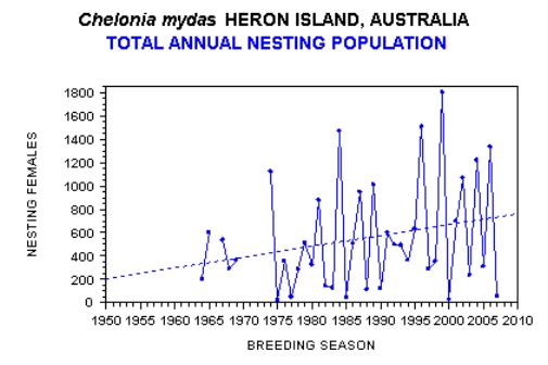
- Green Turtles (Chelonia mydas)
Green Turtles are listed as Vulnerable in Queensland and they also rely on the seagrass to live in tropical and subtropical area. Without the seagrass plants, this directly affect the turtles by losing their habitats. This results in the same result for Dugongs and reduce the number of the species.
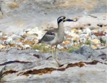
- Beach stone curlew (Esacus magnirostris)
Beach stone curlew is listed as Vulnerable in Queensland. They can be found on Rocky shores and nearby the mangrove forests. Without both of them, no more places for the curlew to live with. This will also reduce the number of them and unbalance the food web in the Cockle Bay.
Legal Status
Magnetic island serves as a National Park in Townsville and the Cockle Bay should be protected under different acts.
- Historic Shipwreck Act 1976
To development a marina on Cockle Bay, the land and sea have to be clear. The SS City of Adelaide has to be removed. However, based on this act, it protects historic ship wreck which has already existed for more than 75 years. It also mentions that recreational development can be started but the wreck is not allowed to remove unless permits are possessed.
- Great Barrier Reef Marine Park Act 1975
To create the channel from Cockle Bay to Great Barrier Reef Marine Park, this act has to be followed. The Great Barrier Reef Marine Park Act 1975 protects the park area by not letting any company to have construction in there. To carry out any further proposal activity, permits have to be got from the Queensand government.
- Recreation Areas Management Act 2006
To finish the whole development, a comprehensive plan should be made. This act protects the whole nature environment where the marina is going to be built. It should be made sure that no damages are created during the proposal.
Socio- Economic Impacts
Cockle Bay is currently a quiet beach with boats storing around. It is a quite an open area and no investment at the moment. Also, it is a comfy place for nature lovers to enjoy the views.
- Social and cultural impacts
Positive impacts can be brought in the social fields. With the new channel to Marine Park, people can be more convenient to pass by. Its existence also reduces the distance of 2 km from Nelly bay to Marine Park. It also improves education about seagrass and mangroves via the planned interpretive centre. However, negative impacts are fairly more. Different forms of pollution will occur with the proposal of work. During the work, toxic waste materials will be liberated into the air or the sea and results in harassment to organisms nearby. This will lead to air and water pollution. In addition, the machines produce a lot of noises which then noise pollution will be led. All of these ends with consequences that human will reap what they have sown. People that have monitoring watches of the ecosystem will be getting poorer and poorer.
Moreover, with all the new buildings, they obstruct the views of Cockle bay. The nature cannot be viewed anymore. In a nutshell, the bay will be renowned in the name of resort with a lot of facilities and recommendations instead of the power of nature.
- Economic impacts
It is proposed that shopping centres, tavern and residual area will be built up. Cockle bay will finally be some sort of resort areas for the tourist to come. In fact, Cockle bay has its own high potential to develop due to high land values.
Positive impacts can be brought. With more attractions, more income and authority. Since there will be a channel linking to Coral Reef Marine Park, people can come past or go to there. This enhance both Magnetic Island and Coral reef businesses and bring more money. Also, recruiting workers for construction are needed. This will improve the employment rate and life expectation of those who are unemployed. For ferry terminal, apart from being more convenient, the fee is also cheaper. These all will bring an overall positive impact on economical fields for Cockle Bay.
Negative impacts can also be brought. Tourists will be only coming for the convenience of the access channel and the so-called resort. When the proposal is done, there will be no more marine animals near Cockle bay due to the public boat ramp. In addition, the use of money for the proposal will be a huge amount of lump sum to build with. As mentioned in the proposal, approximately 27 lots zoned residential units will be built. This will finally have a competition with Nelly Bay and Picnic Bay business. When there is a competition, the rate bills will also increase.
Based on PNAS, “Seagrass meadows provide high-value ecosystem services such as supporting commercial fisheries worth as much as $3500 ha−1 yr−1”. (PNAS, 2017) When the seagrass is getting removed, proportional amount of money is also losing.
Overall speaking, the development work proposal of Cockle Bay brings huge cultural, social and economic impacts. The development of Cockle Bay does affect the beautiful scenery and the natural environment that we all enjoy in Magnetic Island, the water pollution with the proposal of work and the toxic chemicals during construction will severely disrupt the marine environment and the quality of air, however its benefits are also attractive as it increases the commercial income, Magnetic Island and Coral reef businesses and also brings convenience to tourists to visit Magnetic Island by constructing a channel.
Recommendation
The Sunny Bay Construction proposal should not be allowed to continue due to the negatives impact would do on the ecosystems. There are positive impacts though, but negative impacts have outweighed them. Mangroves and seagrass ecosystems will be destructed from the major few forms of pollutions. Work from proposal like dredging construction affect the seagrass ecosystem whereas excavation for both harbour basin and land destroy the mangrove forests. Without nutrients and sunlight, they will fail to survive and die. Along with the destruction of habitats and food, the number of endangered Dugong and Green Turtle will also reduce. The vulnerable level of endanger Beach Stone- Curlew will also force to migrate when the rocky shores are polluted. Ongoing of the whole proposal is not recommended. Therefore, if the company ignores the consequences and insisted to continue, alternatives and mitigations to proposal should be made to avoid the biggest impact on all ecosystems and ecological fields. After considering the issue in both perspectives, the social and cultural impacts and the economic impacts respectively, there are no clear consequences can be made as the development proposal of the construction in Cockle Bay brings both huge positive and negative impact, so this remains as a difficult decision because it depends whether the government’s will to choose rather to boom the economic and commercial income by this construction proposal work or conserve the beautiful natural environment of Cockle Bay.
Mitigation and Alternatives
Conservation works should be done both before and after the proposal to make sure no further damages will be done. It needs to be ensured that the water and soil nearby but not involving are separated well so they won’t be affected. Instead of merely build up a marina, an interpretive centre can also be built to build up an image of ecofriendly. This might possibly gain the support by some of the conservation organisation and protect the environment. For the huge work project of building up foundations, advanced electrical machines should be involved to make sure the environment is not desperately damaged. It should be made sure that the containment particles and destructed soil are properly handed instead of leaving them in the sea. The work should be done in the mid- day where the tidal pattern is the lowest so the water waves will not be that big. Furthermore, there are also some alternatives for the proposal. For the huge work project of building up foundations, advanced electrical machines should be involved to make sure the environment is not desperately damaged. It should be made sure that the containment particles and destructed soil are properly handled instead of leaving them in the sea. The work should be done in the mid- day where the tidal pattern is the lowest so the water waves will not be that big. The other alternatives is after pumping out the water from the ground, the hydraulic gradient will alter as mentioned in impact part. Artificial recharge should be done, by re-injecting the ground water back to the area of other ground. This can prevent the loss of water resources and also conservation work should be done before and while the construction. When spot soil erosion, it should be remedied at the moment. At the same time, doing these protective measures to the natural environment, the construction can be implemented and reducing the negative harmful impact to the environment caused by the development construction work.
Annotated Bibliography
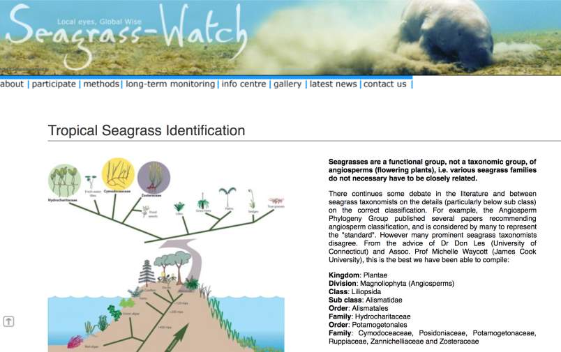
- Tropical Seagrass Identification
(http://www.seagrasswatch.org/id_seagrass.html)
This source is an article about the tropical seagrass identification published by the seagrass watch organisation. This article is introducing different seagrass providing different scientific species name with their physical characteristics such as their size, shape of blade, root and their habitat. This articles is not biased as it does not involve any personal opinion but all are facts measured by the organisation, therefore the information from this source is reliable and accurate, because there are no major contradictions included and its stance is neutral. This article helps me with my proposal by providing various useful information about different names of seagrass and also their characteristics and sizes with photos that assist with my biological drawing of the seagrasses and also allows me to label the parts of the seagrass accurately.
Biology Proposal —— Alpha Shih
Annotated Bibliography
2. Cockle Bay (Queensland) facts (https://kids.kiddle.co Cockle_Bay_(Queensland))
This source is an article about the environmental facts about the Cockle Bay in Magnetic Island. This article is describing the environments of Cockle Bay and also providing various facts of Cockle Bay such as the population, sea tide season and also the height of the sea level. This article is not biased as it does not involve any personal opinion but all are facts stated by the publisher, therefore the information from this source is reliable and accurate, because there are no major contradictions included and its stance is neutral. This article helps me with my proposal by providing various useful information about different informations of Cockle Bay and also its environmental habitat condition with photos that aid me with my proposal about the development of Cockle Bay and also strengthen my consideration about the issue of development of Cockle Bay.
Biology Proposal —— Alpha Shih
Annotated Bibliography
3. Effects of Dredging on the Marine environment
(http://www.seagrasswatch.org/id_seagrass.html)
This source is a featured article about the discussing the effect of dredging on the marine environment published by the “marine insight” website. This featured article provides the definition of dredging activity and also lists out some negative effects of dredging. This featured article withstands the stance of dredging brings a lot of negative effects to the marine ecology and also affect the environmental harmony. However, this article is not biased because it views dredging in both positive and negative way providing practical solutions to the issue of polluting the environment and also states that people should put a balance in between the positive and negative aspects of dredging, thus the information provided in this source is reliable and accurate because there are quotes from marine experts which can further reduce the effect of bias and increase the accuracy and reliability of this source, because there are no major contradictions included and its stance is neutral. This featured article helps me with understanding more about the positive and negative aspects of dredging and also allow me to put those mentioned effects into my proposal.
Biology Proposal —— Alpha Shih
Annotated Bibliography
4. Managing Environmental Impacts of Dewatering
(https://www.groundwatereng.com/blog/2014/02/managing-environmental-impacts-of-dewatering)
This source is a featured article about the discussing impacts of dewatering published by the “Groundwater Engineering” website. This featured article provides the definition of the activity of dewatering and also the technologies to control groundwater like exclusion, pumping and also discussing the potential groundwater and its geotechnical, water resources, water dependent feature, potential mitigation impacts. This featured article is explaining impacts of dewatering in both sides, and most of them are facts, not much personal opinions, so the featured articles is not biased, reliable and accurate with the support of the experts’ quotes which further reduce the bias involved and increase the credibility and accuracy of the information in the article, because there are no major contradictions included and its stance is neutral. This featured article helps me with understanding more about the positive and negative aspects of dewatering and also allow me to put those mentioned effects into my proposal.
Biology Proposal —— Alpha Shih
Annotated Bibliography
5. Mangrove importance
(http://wwf.panda.org/our_work/oceans/coasts/mangroves/mangrove_importance/)
This source is a featured article about the discussing the importance of mangroves trees published by the “WWF Global” organization. This featured article provides information about mangroves and their characteristics, distributions and habitats. It states the importance of mangroves to the surrounding environments. This featured article is neutral, all information are very factual, little personal opinions are involved , thus their featured article is not biased, accurate and reliable, because there are no major contradictions included and its stance is neutral. This featured article helps me with understanding more knowledge about mangroves and how they affect the food chain of the marine ecosystem and their habitats so as to allow me to put those effects of mangroves to the ecosystem into consideration when doing my proposal.
Biology Proposal —— Alpha Shih
Bibliography
- Redland City Council. (2016, May 31). Mangroves. Retrieved from https://www.redland.qld.gov.au/info/20255/plants_and_trees_in_the_redlands/629/mangroves
- Mangroves. (2017). Retrieved from http://museum.wa.gov.au/explore/marine-life-dampier-archipelago/explore-habitats/mangroves
- Mangrove importance. (n.d.). Retrieved from http://wwf.panda.org/about_our_earth/blue_planet/coasts/mangroves/mangrove_importance/
- Reynolds, P. L., Duffy, E., & Knowlton, N. (2018, May 21). Seagrass and Seagrass Beds. Retrieved from http://ocean.si.edu/seagrass-and-seagrass-beds
- TÖPKE, Katrien (2009) Marine Biodiversity Wiki. Retrieved from http://www.marbef.org/wiki/seagrass_meadows
- Marsh, H., Grayson, J., Grech, A., Hagihara, R. and Sobtzick, S. (2015) Dugong. Retrieved from https://www.ehp.qld.gov.au/wildlife/animals-az/dugong.html
- Limpus, C. J. (2009) Green turtle. Retrieved from https://www.ehp.qld.gov.au/wildlife/animals-az/green_turtle.html
- Marchant, S and Higgins PJ (1993) Beach stone-curlew. Retrieved from https://www.ehp.qld.gov.au/wildlife/animals-az/beach_stonecurlew.html
- Historic shipwrecks laws. (1976). Retrieved from http://www.environment.gov.au/heritage/historic-shipwrecks/laws
Biology Proposal —— Alpha Shih
Appendix
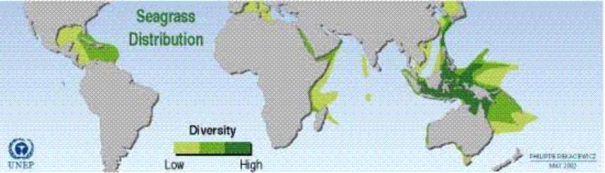
Seagrass distribution in regions
Beach stone-curlew, Picnic Island, Great Sandy Straits Photo: D Stewart, Queensland Government
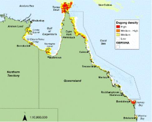
Dugong density: Alana Grech and Helene Marsh, School of Earth and Environmental Sciences, James Cook University, Townsville Qld
The upward trend in the green turtle nesting population at Heron Island. Credit: Queensland Government
Biology Proposal —— Alpha Shih
Field Book Question 2
a) For the smiliarities, mangroves and seagrasses have the similar biotic factors. There are many little animals like insects and crabs dwell in them as habitats. They are the primary producers in their food webs providing food for a diverse range of herbivore (snails, fish. They also contribute a significant amount of leaf litter to support the various detritivores (crabs, snails). They always have a few same abiotic factors like light, temperature, nutrients. Both of two types of organisms need sunlight, temperature and nutrients to live with and grow. In zone 1 there are club, grey and yellow mangroves ; red, yellow and grey mangroves are also found in zone 2 ; red and grey mangroves are also discovered in zone 3. Zone 1, 2 and 3 also consists of grey mangroves, but with different % of composition, zone 1 has the largest composition (20%) of grey mangroves. Additionally, zone 1 has the highest composition (70%) of club mangroves, zone 2 has the largest composition (60%) of red mangroves, zone 3 has the highest composition (70%) of mature red mangroves with height around 4.5 m. For the differences, mangroves is affected by soil salinity due to the special adaptation of themselves. They can live under extreme area like high salt but seagrassess are live in sea and can’t. Seagrass has a better sensation to waves and current of the sea, while mangroves are live on land. Add more detail about abiotic factors e.g. They both live in soft mobile sediments. They both live in environments with high but varying salinity levels. The are both subjected to varying levels of dessication due to the changing tide heights.
b) The seagrass quadrat area was monitered and divided into four 50m transects (totalling 200m in length).
In transect 1 (closest to the shore, 0 – 50m), only one type of seagrass species is seen, which is the Cymodocea serrulata. The percentage of its composition is 100% throughout the whole transect. In the recorded 11 quadrats, different kinds of faunas can be observed such as hermit crabs, shrimps, crab holes, muscle shells, oyster and sea cucumber. More faunas are observed when walking towards to the sea, the number of animals increaes as the going farther to the larger number of quadrat. The sediments also become more sandy and muddy towards the higher number of quadrat. The seagrass coverage for every 5 metres are varied and have different percentages. The average mean of coverage is approximately 20.7% and without a particular pattern in transect 1. In the recording of canopy height, no relationship can be seen between the seagrass coverage and the height. Any percetage of seagrass coverage can have any height measured. The average Canopy height is approximately 9.8cm. For the Algae cover and Epi- cover percentages from 0 to 50 metres, they each have an average of 7.3% and 53.1% respectively.
In transect 2 (50 – 100m from shore), it is really similar to the first one for the seagrass species. There is mostly 100% composition of Cymodocea serrulata in the whole transect. However in the 25m quadrant, Halodule uninervis is located in there and is 50% of the composition. . In the recorded 11 quadrats, different kinds of faunas can be observed such as hermit crabs, shrimps, crab holes, muscle shells, oyster and sea cucumber. More faunas are observed when walking towards to the sea, the number of animals increaes as the going farther to the larger number of quadrat. In the seagrass coverage percentage, it has an average of 11.8% which is markedly less than the first transect. For the canopy height from 0 to 50 metres, it shows a propotional relationship which is that increasing coverage is associated with a higher canopy height. It is recorded that the average canopy height is 11.1cm. Algae and Epi- cover have average 33.1 % and 31.8% respectively.
In transect 3 (100 – 150m from shore), there is only one species of seagrass, which is Cymodocea serrulata again. It has 100% composition throughout the monitoring except for quadrat 9. Quadrat 9 at 40m has no seagrass recorded and only mud and shrimp. . In the recorded 11 quadrats, different kinds of faunas can be observed such as hermit crabs, shrimps, crab holes, muscle shells, oyster and sea cucumber. More faunas are observed when walking towards to the sea, the number of animals increaes as the going farther to the larger number of quadrat. The highest average of canopy height is 9.4cm and doesn’t now have any extreme values. Algae and Epi- cover have average 14.6% and 28.9% respectively.
In transect 4 (150 – 200m from shore), same as transect 3 it has only one species of seagrass, which is Cymodocea serrulata again. It has 100% seagrass coverage composition throughout the monitoring process in 11 quadrats. In these 11 quadrats, the sediment is observed as the sandy mud, fauna like hermit crab, seacucumber, oyster are noticed. When walking towards to the sea, the number of animals increaes as the quadrat increases, nearer to the sea. In the recordings of the composition of the algae coverage, quadrat 11 has the highest percentage of algae cover which is 85%. The average of composition of algae cover is 53.2 %, which is the highest percentage of seagrass coverage among the 4 transects.
c)
Graph 1: Historical Seagrass Data for Cockle Bay
Graph 1 shows that there is an inverse relationship between Cymodocea serrulata and Halophila ovalis. This can be seen in the historical data. In the trend, C. serrulata is dominanat in the years from 2006-2009, H. ovalis from 2010-14, and C. serrulata is back to dominance in 2017. When C. serrulata is dominant, H. ovalis is the least dominant species, same for the reverse. The switch of composition is normal due to the climate changes and anthropogenic changes. H. ovalis is a pioneer species and colonises areas when C. serrulata is denuded by some disturbance e.g. Cyclone Yasi in 2011 or big wet season and high sedimentation in 2010. Based on this graph ans what I have observed in Cockle Bay, C. serrulata is dominant in the percentage of composition in different quadrats in the 200m length of transect observation and other species like . H. ovalis is not likely to be noticed in my observation in Cockle Bay, this gives the evidence to the historical seagrass data graph above. Following the trend of the percentage composition of various seagrass species, C. serrulata will become more dominant and occupied nearly all of the composition in the Cockle Bay sediment, and other composition of species will be continuosuly decreasing as the trend illustrates.
Question 3
a) The abitoic factors are sunlight, temperature, substrate type, wave action and tidal pattern. Sunlight and temperature depend on the nutrient the organisms can receive to grow. High tides and low tides have both negative effects on the rock. When it is low tides, the rocks and organisms will not meet the water, this means they will get very dry. When it is high tides, even though the water level will rise, but they are possible to be consumed by the marine animals. From what I have observed in the Cockle Bay, various kind of faunas and rocks are found, such as oysters, snails, sea cucumbers, seagrass and the horizontal rock zonation pattern. Furthermore, I notice that the diversity of animals found in the Cockle Bay is increasing when walking farther from the shore to the sea, like the transect 4, 200m from the shore has more sea creatures and seagrasses and the sendiment is less sand.
b) The organisms are able to withstand the least amount of exposure sunlight and dessication are the oysters and that is why they are situated in the lowest tidal zone. This region is usually covered with water. It is only uncovered when the tide is extremely low. In contrast to the other zones, the organisms are not well adapted to long periods of dryness or to extreme temperatures. Barnacles are able to withstand more time out of the water and therefore they exist in a higher tidal zone. The higher tidal zone can experience extreme temperature changes. The organisms in this zone must be resistant to these changes to survive. Most of the marine organisms are ectothermic and need the warmth from the environment to survive. When the organisms are submerged, they are buffered against temperature changes, because the water is isothermal. Organisms are also threatened by desiccation during emersion at low tides or when they are positioned in the high tidal zones. Limpets are mobile organisms that are able to move to suit their requirements, so that they can avoid the desiccation by migrating to a region that is more suitable. Organisms that are able to withstand the least amount of exposure to sunlight and dessication include algae and corals but these organisms were not found at the survey site, in this low region is usually covered with water. It is only uncovered when the tide is extremely low. In contrast to the other zones, the organisms are not well adapted to long periods of dryness or to extreme temperatures. They are located in the lowest tidal areas in the rocky shores and usually stay in the water to keep wet.
4a) Seagrasses undoubtedly provide many ecosystem services, which are natural processes and components that benefit human needs, directly or indirectly. From my observation in the Cockle Bay, seagrasses are dominant and it brings and attracts more animals to consume them and also benefit the ecosystem services. Seagrasses are often called foundation plant species or ecosystem engineers because they modify their environments to create unique habitats. These modifications not only make coastal habitats more suitable for the seagrasses themselves, but also have important effects on other animals and provide ecological functions and a variety of services for humans. Seagrasses have been used by humans for over 10,000 years. They’ve been used to fertilize fields, insulate houses, weave furniture, thatch roofs, make bandages, and fill mattresses and even car seats. But it’s what they do in their native habitat that has the biggest benefits for humans and the ocean. Seagrasses support commercial fisheries and biodiversity, clean the surrounding water and help take carbon dioxide out of the atmosphere. Because of these benefits, seagrasses are believed to be the third most valuable ecosystem in the world (only preceded by estuaries and wetlands). One hectare of seagrass (about two football fields) is estimated to be worth over $19,000 per year, making them one of the most valuable ecosystems on the planet. (Ocean portal, 2017). Seagrass meadows produce a variety of goods (finfish and shellfish) and provide ecological services (maintenance of marine biodiversity, regulation of the quality of coastal waters, protection of the coast line) which are directly used or beneficial to humans and condition the economic development of European coastal zones. In addition seagrasses are indicators of the status of the coastal zone which can be used in coastal management strategies aiming at preserving or improving the environmental quality of the coastal zone.
b) The mangroes habitat in Cockle bay has dense root systems which form a home for fish, crabs, shrimps, and molluscs viewed at Cockle Bay in this biology excursion trip. Mangrove habitats also serve as nurseries for juvenile fish. Many coral reef fish, for example, spawn in mangrove forests. The young fish stay in the forest, where there is plenty of food and they can shelter from predators, until they are old enough to move to the reef.
In addition, mangrove forests are nesting and migratory sites for hundreds of bird species, as well as home to a wide variety of reptile, amphibian, and mammal species. For example, the Sunderban mangroves of India and Bangladesh – the largest mangrove forest on Earth – are home to Bengal tigers, spotted deer, saltwater crocodiles, fishing cats, and various dolphin species. (WWF, 2017)
From my observation in the Cockle Bay, the mangroves habitat not only act as shelters for aimals but also balance the food web in the ecosystem. Mangroves habitat provide a number valuable ecosystem services that contribute to human wellbeing, including provisioning (e.g., timber, fuel wood, and charcoal), regulating (e.g., flood, storm and erosion control; prevention of salt water intrusion), habitat (e.g., breeding, spawning and nursery habitat for commercial fish species; biodiversity), and cultural services (e.g., recreation, aesthetic, non-use).
Question 5
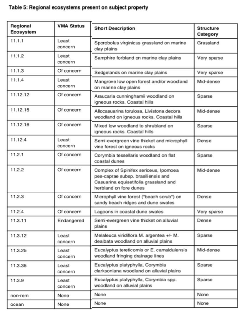
(Qld Government DNRM, 2018)
VMA status:
Of concern
A regional ecosystem is listed as ‘of concern’ under the Act if:
remnant vegetation is 10–30% of its pre-clearing extent across the bioregion; or
more than 30% of its pre-clearing extent remains and the remnant extent is less than 10,000ha.
In addition to the criteria listed for an ‘of concern’ regional ecosystems under the Act, for biodiversity planning purposes a regional ecosystem is listed with a biodiversity status ‘of concern’ if:
10–30% of its pre-clearing extent remains unaffected by moderate degradation and/or biodiversity loss.
No concern at present/Least concern
A regional ecosystem is listed as ‘least concern’ under the Act if: remnant vegetation is over 30% of its pre-clearing extent across the bioregion, and the remnant area is greater than 10,000ha.
In addition to the criteria listed for ‘least concern’ regional ecosystems under the Act, for biodiversity planning purposes a regional ecosystem is listed with a biodiversity status of ‘no concern at present’ if: the degradation criteria listed above for ‘endangered’ or ‘of concern’ regional ecosystems are not met.
(Qld government, 2018)
I = International Q = Queensland A = Australia
Question 6
| Kingdom | Class | Family | Scientific Name | Common Name | I/Q/A | Records | |
| Animals | Birds | Burhinidae | Esacus magnirostris | Beach stone- curlew | Q | Vulnerable | 11 |
| Animals | Birds | Charadriidae | Charadrius leschenaultii | Greater sand plover | Q and A | Vulnerable | 1 |
| Animals | Birds | Charadriidae | Charadrius mongolus | Lesser sand plover | Q and A | Endangered | 2 |
| Animals | Birds | Procellariidae | Ardenna pacifica | Wedge-tailed shearwater | Q | Vulnerable | 1 |
| Animals | Birds | Psittacidae | Cyclopsitta diophthalma macleayana | Macleay’s fig-parrot | Q | Vulnerable | 2 |
| Animals | Birds | Scolopacidae | Numenius madagascariensis | eastern curlew | Q and A | Endangered and Critically Endangered | 20 |
| Animals | Birds | Scolopacidae | Limosa lapponica baueri | Western Alaskan bar-tailed godwit | Q and A | Vulnerable | 8 |
| Animals | Mammals | Balaenopteridae | Megaptera novaeangliae | humpback whale | Q and A | Vulnerable | 3 |
| Animals | Mammals | Dasyuridae | Dasyurus hallucatus | northern quoll | A | Endangered | 1 |
| Animals | Mammals | Delphinidae | Orcaella heinsohni | Australian snubfin dolphin | Q | Vulnerable | 3/1 |
| Animals | Mammals | Delphinidae | Sousa sahulensis | Australian humpback dolphin | Q | Vulnerable | 1/1 |
| Animals | Mammals | Dugongidae | Dugong dugon | dugong | I
& Q |
Vulnerable | 8/1 |
| Animals | Mammals | Phascolarctidae | Phascolarctos cinereus | Koala | Q and A | Vulnerable | 25 |
| Animals | Reptiles | Cheloniidae | Eretmochelys imbricata | hawksbill turtle | Q and A | Endangered and Vulnerable | 2 |
| Animals | Reptiles | Cheloniidae | Natator depressus | flatback turtle | Q and A | Vulnerable | 1 |
| Animals | Reptiles | Cheloniidae | Chelonia mydas | green turtle | I,
Q and A |
Vulnerable | 8 |
| Animals | Reptiles | Crocodylidae | Crocodylus porosus | estuarine crocodile | Q | Vulnerable | 2 |
| Animals | Reptiles | Elapidae | Acanthophis antarcticus | common death adder | Q | Vulnerable | 2 |
| Animals | Reptiles | Scincidae | Lampropholis mirabilis | saxicoline sunskink | Q | Near-threatened | 6/3 |
| Plants | Higher dicots | Euphoribiaceae | Croton magneticus | Q | Vulnerable | 3/3 | |
| Plants | Higher dicots | Solanaceae | Solanum sporadotrichum | Q | Near- threatened | 2/2 | |
| Plants | Higher dicots | Sparrmanniaceae | Corchorus hygrophilus | Q | Vulnerable | 2/2 |
(Qld Government DNRM, 2018)
c)
The Beach Stone-Curlew was observed within Cockle Bay and is listed as Vulnerable to extinction.
The Green Turtle and Dugong are known to inhabit the bay however they were not sighted during the recent survey.
Bibliography:
Operations Support, D. o. (2017). Vegetation Mangement Report . Queensland Government .
Mangrove forest: ecosystem. (n.d.). Retrieved from WWF Global: http://wwf.panda.org/about_our_earth/blue_planet/coasts/mangroves/mangrove_ecosystems/
Reynolds, P. L. (n.d.). Seagrass and Seagrass Beds. Retrieved from Ocean portal: http://ocean.si.edu/seagrass-and-seagrass-beds
Biodiversity status and vegetation management class. (2017, 5 2). Retrieved from Queensland Government: https://www.qld.gov.au/environment/plants-animals/plants/ecosystems/biodiversity-status
https://www.qld.gov.au/environment/plants-animals/plants/ecosystems/biodiversity-status
file:///L:/wildlife_online20170816093029.pdf
http://ocean.si.edu/seagrass-and-seagrass-beds
http://wwf.panda.org/about_our_earth/blue_planet/coasts/mangroves/mangrove_ecosystems/
Cite This Work
To export a reference to this article please select a referencing stye below:
Related Services
View all


Related Content
All TagsContent relating to: "Marine Studies"
Marine studies look at the oceans and seas from the resources they provide, the diverse organisms and life that live in them to the threats and effects of climate change on marine habitats.
Related Articles

DMCA / Removal Request
If you are the original writer of this dissertation and no longer wish to have your work published on the UKDiss.com website then please: